Northchurch

Last updated

Northchurch
Northchurch - St Mary's Church - geograph.org.uk - 590845.jpg
St Mary's Church, Northchurch
Hertfordshire UK location map.svg
Red pog.svg
Northchurch
Location within Hertfordshire
Population2,813 (2011 Census including Cow Roast) [1]
OS grid reference SP974088
District
Shire county
Region
Country England
Sovereign state United Kingdom
Post town Berkhamsted
Postcode district HP4
Dialling code 01442
Police Hertfordshire
Fire Hertfordshire
Ambulance East of England
UK Parliament
List of places
UK
England
Hertfordshire
51°46′11″N0°35′26″W / 51.76979°N 0.59050°W / 51.76979; -0.59050

Northchurch is a village and civil parish in the Bulbourne valley in the county of Hertfordshire in the United Kingdom. It lies between the towns of Berkhamsted and Tring.

Contents

Situated on the Roman road Akeman Street, a major Roman villa dating from about AD 60 was discovered in the village in the 1970s. The settlement predates the neighbouring larger town of Berkhamsted. [2]

History

The almshouses, or Church House, dating to the 15th and 16th centuries, are on Northchurch High Street Northchurch, The High Street - geograph.org.uk - 590808.jpg
The almshouses, or Church House, dating to the 15th and 16th centuries, are on Northchurch High Street

Other earlier names for Northchurch include Berkhamsted St. Mary and Berkhamsted Minor. Both names support the view that Northchurch may have been the site of the original Berkhamsted which expanded down the Bulbourne Valley following the construction of Berkhamsted Castle 2 miles to the south west. [2] [3] The village eventually became known as the area around the North Church, St. Mary's lying to the Northwest of the newer Parish Church of St. Peter built to the southeast nearer the Castle.

Norcott Hall Norcott Hall, Northchurch - geograph.org.uk - 1372911.jpg
Norcott Hall
Grand Union Canal Grand Union Canal, Dudswell Bottom Lock No 48 - geograph.org.uk - 1514967.jpg
Grand Union Canal
St Mary's School St Mary's School, Northchurch - geograph.org.uk - 1248949.jpg
St Mary's School

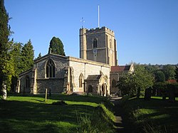
The parish church of St. Mary dates from Saxon times and is one of the oldest churches in Hertfordshire. Part of the original Saxon building remains in the south and west walls. Flint wall extensions were built between the 11th and 14th centuries, to form a cruciform building. A stone-faced tower was added over the crossing during the 15th century. A Victorian north aisle, vestries and south porch were added in the 1880s. [2]

The village stands on both the River Bulbourne and the Grand Union Canal. The main road running through Northchurch, the A4251, is built over Akeman Street, the original Roman road from London (Londinium) to Cirencester (Corinium). The almshouses, or Church House, are two-storey half-timbered houses dating from the 15th and 16th centuries. From 1936 until 1972 Northchurch and Berkhamsted were united under Berkhamsted Urban District Council. Northchurch today, however, is recognised as a separate village with its own Parish Council.

St Mary's churchyard contains the grave of Peter the Wild Boy, a German feral child adopted at the court of King George I and II. His grave can be seen directly outside the main door to the church. [2] [4]

Related Research Articles

<span class="mw-page-title-main">Berkhamsted</span> Town in Hertfordshire, England

Berkhamsted is a historic market town in Hertfordshire, England, in the Bulbourne valley, 26 miles (42 km) north-west of London. The town is a civil parish with a town council within the borough of Dacorum which is based in the neighbouring large new town of Hemel Hempstead. Berkhamsted, along with the adjoining village of Northchurch, is encircled by countryside, much of it in the Chiltern Hills which is an Area of Outstanding Natural Beauty (AONB).

<span class="mw-page-title-main">Welwyn</span> Human settlement in England

Welwyn is a village and civil parish in Hertfordshire, England. The parish also includes the villages of Digswell and Oaklands. It is sometimes referred to as Old Welwyn or Welwyn Village, to distinguish it from the much newer and larger settlement of Welwyn Garden City, about a mile to the south.

<span class="mw-page-title-main">Tring</span> Market town in Hertfordshire, England

Tring is a market town and civil parish in the Borough of Dacorum, Hertfordshire, England. It is situated in a gap passing through the Chiltern Hills, classed as an Area of Outstanding Natural Beauty, 30 miles (50 km) from Central London. Tring is linked to London by the Roman road of Akeman Street, by the modern A41 road, by the Grand Union Canal and by the West Coast Main Line to London Euston. Settlements in Tring date back to prehistoric times and it was mentioned in the Domesday Book; the town received its market charter in 1315. Tring is now largely a commuter town within the London commuter belt. As of 2013, Tring had a population of 11,731.

<span class="mw-page-title-main">Nettleden</span> Human settlement in England

Nettleden is a village and former civil parish, now in the parish of Nettleden with Potten End, in the Dacorum district, in the county of Hertfordshire, England. It is in the Chiltern Hills, about four miles north-west of Hemel Hempstead, near Little Gaddesden, Great Gaddesden and Frithsden. In 1931 the parish had a population of 133.

<span class="mw-page-title-main">Kings Langley</span> Village and civil parish in Hertfordshire, England

Kings Langley is a village, former manor and civil parish in Hertfordshire, England, 21 miles north-west of Westminster in the historic centre of London and to the south of the Chiltern Hills. It now forms part of the London commuter belt. The village is divided between two local government districts by the River Gade with the larger western portion in the Borough of Dacorum and smaller part, to the east of the river, in Three Rivers District. It was the location of Kings Langley Palace and the associated King's Langley Priory, of which few traces survive.

<span class="mw-page-title-main">Bourne End, Hertfordshire</span> Human settlement in England

Bourne End is a village in Hertfordshire, England. It is situated on the ancient Roman Akeman Street between Berkhamsted and Hemel Hempstead, on the former A41 London-Liverpool Trunk Route, on the Grand Union Canal that runs between London and Birmingham and at the confluence of the Chiltern chalk stream, the Bourne Gutter and the River Bulbourne. It is in the Dacorum Ward of Bovingdon, Flaunden and Chipperfield.

<span class="mw-page-title-main">Great Wymondley</span> Village in Hertfordshire, England

Great Wymondley is a village and former civil parish situated near Hitchin, now in the parish of Wymondley, in the North Hertfordshire district, in the county of Hertfordshire, England. Despite the names, Great Wymondley is a smaller settlement than its neighbour, Little Wymondley. In 1931 the parish had a population of 285.

<span class="mw-page-title-main">River Bulbourne</span> River in Hertfordshire, England

The River Bulbourne is a small river in Dacorum, Hertfordshire, England. The word bourne derives from the Anglo-Saxon word for a stream. It is an unnavigable tributary of the River Gade, which flows into the River Colne, which in turn is a tributary of the River Thames. The Bulbourne is an example of a chalk stream, which is a watercourse that flows from chalk-fed groundwater. Chalk streams are a very rare habitat globally, with more than 85% of all the 210 chalk streams in the world are found in England. The river is reduced in size, due to human activity, the main one being the building of the London to Birmingham Grand Union Canal through the narrow valley which takes most of the river's water.

<span class="mw-page-title-main">Peter the Wild Boy</span> German feral child

Peter the Wild Boy was a boy from Hanover in northern Germany who was found in 1725 living wild in the woods near Hamelin, the town of Pied Piper legend. The boy, of unknown parentage, had been living an entirely feral existence for an unknown length of time, surviving by eating forest flora; he walked on all fours, exhibited uncivilized behaviour and could not be taught to speak a language. He is now believed to have suffered from the very rare genetic disorder Pitt–Hopkins syndrome.

<span class="mw-page-title-main">Middleton Stoney</span> Human settlement in England

Middleton Stoney is a village and civil parish about 2+12 miles (4 km) west of Bicester, Oxfordshire. The 2011 Census recorded the parish's population as 331.

<span class="mw-page-title-main">Little Gaddesden</span> Human settlement in England

Little Gaddesden is a village and civil parish in the borough of Dacorum, Hertfordshire 3 miles (4.8 km) north of Berkhamsted. As well as Little Gaddesden village, the parish contains the settlements of Ashridge, Hudnall, and part of Ringshall. The total population at the 2011 Census was 1,125. Little Gaddesden is an area of outstanding natural beauty (AONB) and a conservation area protected by the National Trust.

<span class="mw-page-title-main">North Leigh</span> Human settlement in England

North Leigh is a village and civil parish about 3 miles (5 km) northeast of Witney in Oxfordshire. The parish includes the hamlet of East End and since 1932 has also included the hamlet of Wilcote. The 2011 Census recorded the parish's population as 1,929.

<span class="mw-page-title-main">Wootton, West Oxfordshire</span> Human settlement in England

Wootton is a village and civil parish on the River Glyme about 2 miles (3 km) north of Woodstock, Oxfordshire. In recent years the village is sometimes referred to as Wootton-by-Woodstock to distinguish it from Wootton, Vale of White Horse. The 2011 Census recorded the parish's population as 569.

<span class="mw-page-title-main">Primary schools in Dacorum</span>

This article gives brief information on schools that cater for pupils up to the age of 11 in the Dacorum district of Hertfordshire, England. Most are county maintained primary schools, sometimes known as "junior mixed infant" (JMI). A small number are voluntary aided church schools or independent (fee-paying). The Local Education Authority is Hertfordshire County Council.

<span class="mw-page-title-main">Cow Roast</span> Human settlement in England

Cow Roast is a hamlet within the civil parishes of Northchurch and Wigginton in Hertfordshire, England. It is between Tring and Berkhamsted, along the A4251, adjacent to the Grand Union Canal and the West Coast Main Line. Today it comprises a row of 20th-century houses and a marina, together with several older properties including a public house. There are three car dealerships and a petrol station beside the main road.

<span class="mw-page-title-main">Potten End</span> Human settlement in England

Potten End is a village in west Hertfordshire, England. It is located in the Chiltern Hills, two miles (3.2 km) east-north-east of Berkhamsted, three miles (4.8 km) north west of Hemel Hempstead and two miles south east of the National Trust estate of Ashridge. Nearby villages include Nettleden, Great Gaddesden and the hamlet of Frithsden. The village is part of the parish of Nettleden with Potten End within the borough of Dacorum.

Nettleden with Potten End is a civil parish in Hertfordshire, England, covering the villages of Potten End and Nettleden and the surrounding rural area.

<span class="mw-page-title-main">Chesterton, Oxfordshire</span> Human settlement in England

Chesterton is a village and civil parish on Gagle Brook, a tributary of the Langford Brook in north Oxfordshire. The village is about 1+12 miles (2.4 km) southwest of the market town of Bicester. The village has sometimes been called Great Chesterton to distinguish it from the hamlet of Little Chesterton, about 34 mile (1.2 km) to the south in the same parish. The 2011 Census recorded the parish population as 850.

<span class="mw-page-title-main">Berkhamsted Castle</span> Norman castle in Hertfordshire, UK

Berkhamsted Castle is a Norman motte-and-bailey castle in Berkhamsted, Hertfordshire. The castle was built to obtain control of a key route between London and the Midlands during the Norman conquest of England in the 11th century. Robert of Mortain, William the Conqueror's half brother, was probably responsible for managing its construction, after which he became the castle's owner. The castle was surrounded by protective earthworks and a deer park for hunting. The castle became a new administrative centre of the former Anglo-Saxon settlement of Berkhamsted. Subsequent kings granted the castle to their chancellors. The castle was substantially expanded in the mid-12th century, probably by Thomas Becket.

<span class="mw-page-title-main">Church of St Peter, Great Berkhamsted</span> Church in Hertfordshire, United Kingdom

The Parish Church of St Peter, Great Berkhamsted, is a Church of England, Grade II* listed church in the town of Berkhamsted, Hertfordshire, in the United Kingdom. It stands on the main High Street of the town and is recognisable by its 85-foot (26 m) clock tower.

References

  1. "Civil Parish population 2011". Neighbourhood Statistics. Office for National Statistics. Retrieved 28 October 2016.
  2. 1 2 3 4 St Mary's church - Our History Archived 12 March 2012 at the Wayback Machine Accessed July 2011
  3. Birtchnell P, A Short History of Berkhamsted, Clunberry Press 1972
  4. Peter the Wild Boy's condition revealed 200 years after his death Maev Kennedy, The Guardian 20 March 2011