| Weston | |
|---|---|
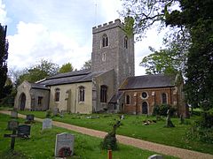 Holy Trinity Church, Weston | |
 Weston Location within Hertfordshire | |
| Population | 1,054 (2011 Census) [1] |
| OS grid reference | TL260303 |
| District | |
| Shire county | |
| Region | |
| Country | England |
| Sovereign state | United Kingdom |
| Post town | HITCHIN |
| Postcode district | SG4 |
| Dialling code | 01462 |
| Police | Hertfordshire |
| Fire | Hertfordshire |
| Ambulance | East of England |
| UK Parliament | |
Weston is a village and civil parish in the North Hertfordshire district of Hertfordshire, England. In 2011 the parish had a population of 1054.
Contents
It is located around 4 miles north of Stevenage, 2.5 miles south of Baldock and the same distance south-east of Letchworth, although it lies in the Hitchin post town. The A1(M) motorway passes to the west and the A505 Baldock bypass to the north, in a cut-and-cover tunnel that passes through the Weston Hills. These hills were made famous by the Robin Hood-style character Jack o'Legs, who was allegedly buried in the village's church graveyard.
Weston Road and the Village of Weston, both within Toronto, were named after this place.