| Buckland | |
|---|---|
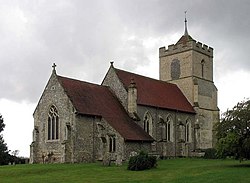 St Andrew's, parish church | |
 Buckland Location within Hertfordshire | |
| Population | 274 (parish, including Chipping) (2011 Census) [1] |
| OS grid reference | TL 35597 33638 |
| Civil parish |
|
| District | |
| Shire county | |
| Region | |
| Country | England |
| Sovereign state | United Kingdom |
| Post town | Buntingford |
| Postcode district | SG9 |
| Dialling code | 01763 |
| Police | Hertfordshire |
| Fire | Hertfordshire |
| Ambulance | East of England |
| UK Parliament | |
Buckland is a village and civil parish in the East Hertfordshire district of Hertfordshire, England. The village is situated on the A10 road, with the market town of Royston situated 41⁄2 miles north and Buntingford 3 miles south. According to the 2011 census, the parish of Buckland, including the hamlet of Chipping has a population of 274. [2]