Buntingford

Last updated

Buntingford
High Street, Buntingford.jpg
Buntingford
Hertfordshire UK location map.svg
Red pog.svg
Buntingford
Location within Hertfordshire
Population7,879 (2021 Census) [1]
OS grid reference TL363292
Civil parish
  • Buntingford
District
Shire county
Region
Country England
Sovereign state United Kingdom
Post town BUNTINGFORD
Postcode district SG9
Dialling code 01763
Police Hertfordshire
Fire Hertfordshire
Ambulance East of England
UK Parliament
List of places
UK
England
Hertfordshire
51°56′40″N0°00′58″W / 51.9445°N 0.0160°W / 51.9445; -0.0160

Buntingford is a market town and civil parish in the district of East Hertfordshire and county of Hertfordshire in England. It lies next to the River Rib and is located on the historic Roman road, Ermine Street. As a result of its location, it grew mainly as a staging post with many coaching inns and has an 18th-century one-cell prison known as The Cage, by the ford at the end of Church Street. It has a population of 7879, as of the 2021 UK Census.

Contents

Name

The ford in Buntingford that gives it its name Buntingford Ford.jpg
The ford in Buntingford that gives it its name

Despite popular belief, the name of Buntingford does not come from the bunting bird. [2] Instead, it probably originates from the Saxon chieftain or tribe Bunta and the local ford running over the River Rib. [3] Buntingford was the name of the ford and its surrounding areas, with Bunting being the name of a village located six miles to its north, which is translated from Old English as "place or people of Bunta". [4] The earliest forms of the name Buntingford are Buntas Ford and Buntingeford, both of which date back to 1185. [5] [6] The modern form Buntingford dates back to 1255. [lower-alpha 1] This roughly translates to "Ford of the people of Bunta". [5]

History

Buntingford was first recorded in an 1185 Knights Templar land document. Henry III designated it a market town by royal charter in 1253. [6] [7] Elizabeth de Burgh, 4th Countess of Ulster, relocated her market in Chipping to Buntingford in 1360, [8] under permission from Edward III. She then gave the market to the town's residents, turning it into one of England's first community owned markets. [2]

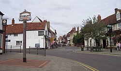
Buntingford was located traditionally within the parish of Layston – St Bartholomew's Church (Layston), previously derelict and now a house, lies about half a mile to the north-east of the town. St Peter's Church, formerly a relief chapel, is the Anglican church in Buntingford and is an almost unique brick building from the age of the 17th-century Puritans. St Richard's serves the Roman Catholic community. There is also a United Reformed Church in Baldock Road. Queen Elizabeth I is claimed to have stayed at Buntingford in a building now called the Bell House Gallery, on a coach journey to Cambridge. [9] Just up the High Street, The Angel Inn, now a dental surgery, was a staging post for coaches travelling from London to Cambridge. The town has an annual firework display at The Bury, presented by Buntingford Town Football Club. The Prime Meridian passes to the east of Buntingford. The town has many Georgian and medieval buildings, such as Buntingford almshouses, Buntingford Manor House and the Red House. Buntingford was a stop-over on what was the main route between London and Cambridge, now the A10.

Governance

Buntingford is in East Hertfordshire, a shire district in the county of Hertfordshire, [10] and the parliamentary constituency of North East Hertfordshire (formerly North Hertfordshire), [11] a Conservative safe seat represented by Sir Oliver Heald since 1992. [12] [13] Previously, between 1983 and 1997, Buntingford was located in the constituency of Hertford and Stortford, [14] [15] which at the time was represented by Conservative Bowen Wells. [16]

Hertfordshire has three-tier local government, meaning responsibilities for local government are split between county councils, district councils, and parish councils (including town councils). Buntingford is managed by Buntingford Town Council, East Hertfordshire District Council and Hertfordshire County Council. Buntingford is represented on the district council by Stan Bull and Jeff Jones of the Buntingford Conservatives, [17] the local branch of the Conservative Party founded in 2015. [18] Jones also represents Buntingford in the county council. [19] The district and county councils are headquartered in Hertford, while the town council is headquartered in Buntingford. The town council is based from Buntingford Manor House [20] and elects councillors every four years. The Town Clerk is currently Jill Jones and the Town Council Officer is currently Alexander Georgiou. Town Mayor Graham Waite was elected in 2018 and is serving with his deputy, Steve Bowman. [21] [22]

Before the creation of East Hertfordshire on 1 April 1974, Buntingford was part of the Braughing Rural District, which was abolished on 31 March 1974. The district was headquartered in Buntingford and Bishop's Stortford and was formed from the merger of the Hadham and Buntingford Rural Districts on 1 April 1935. [23] Buntingford Rural District evolved from Buntingford Rural Sanitary District, existing between 28 December 1894 and 31 March 1935. [24]

Culture

Market day is Monday, and early closing Wednesday. The Buntingford Carnival is held every other year. There is also a classic car event held in the town each year, on the first Saturday in September. The town has a number of public houses – The Brambles (formerly The Chequers), The Fox and Duck, The Black Bull, The Crown and The Jolly Sailors. The 'World Sausage Tossing Championship' has taken place at The Countryman Inn, in Chipping near Buntingford, every August since 2014. [25]

Transport

Buntingford railway station, opened in 1863, was closed in 1964, [26] under the Beeching cuts. This was the terminus for the Buntingford Branch Line. Recently it has been redeveloped into housing.

Economy

Buntingford is home to various independent shops, restaurants and pubs mainly located in the town's high street. Buntingford has a Co-op food supermarket and a Sainsbury's Local. Just outside the town are two fuel stations one at each end of the bypass. One is operated by BP , the other by Esso that opened in 2022. The town was previously home to the Sainsbury's Anglia Distribution Centre, but this was vacated and eventually knocked down for housing in 2014. The site had previously been used as a Royal Army Ordnance Corps munitions factory, known locally as "the Dump". [27] Team BMR and Triple Eight Racing, two major UK auto racing teams, were based in the town. [28] [29]

Education

Buntingford is one of two towns in Hertfordshire using a three-tier school system (the other being Royston). In this system, children are educated in first schools until they enter middle school in Year Five, after which they join upper school in Year Nine, remaining there until the completion of sixth form. [30] This system was enacted in Buntingford in 1969 by order of the county council. [31]

First and middle schools

There is currently one middle school and two first schools, with a third opening in September 2023:

Secondary education

Freman College pictured in 2007 Freman College, Buntingford - geograph.org.uk - 471675.jpg
Freman College pictured in 2007

Buntingford currently has one upper school, Freman College (formerly Ward Freman School). The school is a mixed upper school and sixth form with academy status, situated at Bowling Green Lane, Buntingford, under the control of its own single-academy trust. [45] It was established in either 1970 or 1971 [46] [47] as an 11 to 16 comprehensive school, [48] replacing the Buntingford Secondary Modern School which was established between both world wars. [49] [47] It was named after Bishop Seth Ward and Elizabeth Freman of the Freman family as both were benefactors of Buntingford's old grammar school that closed in 1900. Previously a foundation school, Freman converted to academy status in 2011, being one of the first schools to do so. [47] It has had an Ofsted grading of good since 2006 [50] [51] and has a student population of 961, with a capacity for 903. [45]

A grade II listed house situated at Layston Court 20, High Street, was formerly used as the building and master's house for Buntingford Grammar School until 1877. [52] Buntingford Grammar School was Buntingford's first secondary school, [53] having been built by its endower, Elizabeth Freman, between 1630 and 1633 for 25 schoolboys and a master. It was a two-storey building, with the attic being added at a later date sometime before 1830. The school was endowed again in 1684 by former pupil Seth Ward, who had become the Bishop of Salisbury, and Lady Jane Barkham. [52] After its disuse in 1877, the building was modified into a house. The Town Council took ownership of the rest of the school's site and have preserved it as a park. [54] The school itself survived elsewhere until 1900. [53]

Notable people

Athletes

Bishops

Politicians

Others

Twin towns

Media

Local news and television programmes are provided by BBC East and BBC London on BBC One, and by ITV Anglia and ITV London on ITV1. Television signals are received from either the Sandy Heath or Crystal Palace TV transmitters. [72] [73] Local radio stations are BBC Three Counties Radio and Heart Hertfordshire. The town is served by the local newspaper, Hertfordshire Mercury (formerly The Buntingford and Royston Mercury). [74]

Other Media

The Beehive, a pub situated at Hare Street, Buntingford, is featured in the 1981 television adaptation of The Hitchhiker's Guide to the Galaxy radio series. [75] It reappears in the series' 2005 film adaptation as the Horse and Groom, which is named the "last pub in the world". [76] [77]

See also

Notes

  1. Other forms historically used include Bontingford, Buntiford, Buntyngeford and Bountyngeford. [5]

Related Research Articles

<span class="mw-page-title-main">Hertfordshire</span> County of England

Hertfordshire is a ceremonial county in the East of England and one of the home counties. It borders Bedfordshire to the north-west, Cambridgeshire to the north-east, Essex to the east, Greater London to the south, and Buckinghamshire to the west. The largest settlement is Watford, and the county town is Hertford.

<span class="mw-page-title-main">Welwyn Hatfield</span> Place in England

Welwyn Hatfield is a local government district with borough status in the county of Hertfordshire, England. Its council is based in Welwyn Garden City. The borough borders Hertsmere, St Albans, North Hertfordshire, East Hertfordshire, Broxbourne, and the London Borough of Enfield.

<span class="mw-page-title-main">Royston, Hertfordshire</span> Town in Hertfordshire, England

Royston is a town and civil parish in the District of North Hertfordshire and county of Hertfordshire in England.

<span class="mw-page-title-main">Hitchin</span> Market town in Hertfordshire, England

Hitchin is a market town in the North Hertfordshire district of Hertfordshire, England. The town dates from the 7th Century and is notable in the present day as being a commuter town for London.

<span class="mw-page-title-main">Stevenage</span> Town and borough in Hertfordshire, England

Stevenage is a large town and borough in Hertfordshire, England, about 27 miles (43 km) north of London. Stevenage is east of junctions 7 and 8 of the A1(M), between Letchworth Garden City to the north and Welwyn Garden City to the south. In 1946, Stevenage was designated the United Kingdom's first New Town under the New Towns Act.

<span class="mw-page-title-main">Watford</span> Town and borough in Hertfordshire, England

Watford is a town and borough in Hertfordshire, England, 15 mi (24 km) north-west of Central London, on the banks of the River Colne.

<span class="mw-page-title-main">Hertford</span> Human settlement in England

Hertford is the county town of Hertfordshire, England, and is also a civil parish in the East Hertfordshire district of the county. The parish had a population of 26,783 at the 2011 census.

<span class="mw-page-title-main">Bishop's Stortford</span> Commuter town in Hertfordshire, England

Bishop's Stortford is a historic market town in the London Commuter Belt. Located on the border of Hertfordshire and Essex, just west of the M11 motorway and Stansted Airport, it is 22 miles north-east of Central London and 34 minutes away by rail from London Liverpool Street. The town had an estimated population of 41,088 in 2020. The district of East Hertfordshire, where the town centre is located, has been ranked as the best place to live in the UK by the Halifax Quality of Life annual survey in 2020. The town is commonly known as Stortford by locals.

<span class="mw-page-title-main">Borough of Broxbourne</span> Place in England

The Borough of Broxbourne is a local government district with borough status in Hertfordshire, England. Its council is based in Cheshunt. Other settlements in the borough include Broxbourne, Hoddesdon and Waltham Cross. The eastern boundary of the district is the River Lea. The borough covers 20 square miles (52 km2) in south east Hertfordshire, and had an estimated population of 99,000 in 2021.

<span class="mw-page-title-main">East Hertfordshire</span> Non-metropolitan district in England

East Hertfordshire is one of ten local government districts in Hertfordshire, England. Its council is based in Hertford, the county town of Hertfordshire. The largest town in the district is Bishop's Stortford, and the other main towns are Ware, Buntingford and Sawbridgeworth. At the 2011 Census, the population of the district was 137,687. By area it is the largest of the ten local government districts in Hertfordshire. The district borders North Hertfordshire, Stevenage, Welwyn Hatfield and Broxbourne in Hertfordshire, and Epping Forest, Harlow and Uttlesford in Essex.

<span class="mw-page-title-main">North Hertfordshire</span> Non-metropolitan district in England

North Hertfordshire is one of ten local government districts in the county of Hertfordshire, England. Its council is based in Letchworth. The district borders East Hertfordshire, Stevenage, Welwyn Hatfield, St Albans, Central Bedfordshire, Luton, and South Cambridgeshire.

<span class="mw-page-title-main">Sawbridgeworth</span> Town in Hertfordshire, England

Sawbridgeworth is a town and civil parish in Hertfordshire, England, close to the border with Essex. It is 12 miles (19 km) east of Hertford and 9 miles (14 km) north of Epping. It is the northernmost part of the Greater London Built-up Area.

<span class="mw-page-title-main">Hertford and Stortford (UK Parliament constituency)</span> Parliamentary constituency in the United Kingdom, 1983 onwards

Hertford and Stortford is a constituency currently represented in the House of Commons of the UK Parliament since 2019 by Julie Marson of the Conservative Party.

<span class="mw-page-title-main">North East Hertfordshire (UK Parliament constituency)</span> Parliamentary constituency in the United Kingdom, 1997 onwards

North East Hertfordshire is a constituency represented in the House of Commons of the UK Parliament since 1997 by Oliver Heald, a Conservative.

<span class="mw-page-title-main">Widford, Hertfordshire</span> Human settlement in England

Widford is a village and civil parish between Ware and Much Hadham in the East Hertfordshire district of Hertfordshire in England. It covers an area of approximately 1,167 acres and contains 220 houses. The River Ash flows through the north of the parish. Widford had a population of 534 people in the 2011 census.

<span class="mw-page-title-main">The Hertfordshire and Essex High School</span> Academy in Bishops Stortford, Hertfordshire, England

The Hertfordshire and Essex High School and since 2004 named as The Hertfordshire & Essex High School and Science College, commonly referred to as Herts and Essex, is a secondary level comprehensive single-sex school with a mixed-sex sixth form in Bishop's Stortford, Hertfordshire, England.

<span class="mw-page-title-main">Freman College</span> Academy school in Buntingford, Hertfordshire, England

Freman College is an upper school and sixth form with academy status in Buntingford, Hertfordshire, England. It was established as Ward Freman School in either 1970 or 1971 and became Freman College in 1999. It is named after the late Elizabeth Freman and the Freman family, who currently own the grounds of the school. Of the 788 students at the school in 2006, 198 were enrolled in the Sixth form.

<span class="mw-page-title-main">Clothall</span> Human settlement in England

Clothall is a village and civil parish in the county of Hertfordshire, England, with a population of 358. It is situated 2.25 miles (3.62 km) south-east of Baldock, and is in the district of North Hertfordshire. At the 2011 Census the civil parish had a population of 150. The village contains the Church of St Mary the Virgin, which was built of flint and stone around 1350–70, though parts of the church are older, dating to the 12th century.

<span class="mw-page-title-main">Layston</span> Deserted village in Hertfordshire, England

Layston is a former village and parish located about a kilometre north-east of Buntingford in Hertfordshire, England, at 51°57′50″N 0°00′45″E.

<span class="mw-page-title-main">Buntingford Rural District</span> History of Hertfordshire

Buntingford Rural District was a rural district in Hertfordshire, England from 1894 to 1935, covering the town of Buntingford and a number of surrounding parishes in the north-east of the county.

References

  1. "Buntingford (Hertfordshire, East of England, United Kingdom) - Population Statistics, Charts, Map, Location, Weather and Web Information".
  2. 1 2 Blatchley, Nicholas (22 May 2012). "Hertfordshire's Smallest Town". Herts Memories. Retrieved 15 April 2022.
  3. "Where the town touches the countryside" (PDF). Wheatley. p. 5. Retrieved 15 April 2022.
  4. Bunting, Frank (18 May 2015). "Origin of Buntingford Name". Herts Memories. Retrieved 15 April 2022.
  5. 1 2 3 "Buntingford". English Place-Name Society. Retrieved 15 April 2022.
  6. 1 2 "The Town of Buntingford – Historic Overview" (PDF). Buntingford Town Council. Retrieved 15 April 2022.
  7. "Out and About". buntingford.com. 26 April 1999. Retrieved 15 April 2022.
  8. "A Brief History of Buckland & Chipping". Buckland and Chipping Parish Council. Archived from the original on 1 September 2018. Retrieved 15 April 2022.
  9. Blatchley, Nicholas. "Around Buntingford". Herts Memories.
  10. "Information on East Herts | East Herts District Council". www.eastherts.gov.uk. Retrieved 9 March 2022.
  11. "Constituency". Sir Oliver Heald. Retrieved 9 March 2022.
  12. Barrow, Georgia (13 December 2019). "General Election 2019: Conservative Sir Oliver Heald holds seat in North East Herts". The Comet. Retrieved 9 March 2022.
  13. "About Sir Oliver". Sir Oliver Heald. Retrieved 9 March 2022.
  14. "The Parliamentary Constituencies (England) Order 1983". www.legislation.gov.uk. Retrieved 25 February 2019.
  15. "The Parliamentary Constituencies (England) Order 1995". www.legislation.gov.uk. Retrieved 25 February 2019.
  16. "UK Politics: People in Parliament". BBC News. 28 June 1998.
  17. "Your Councillors". East Hertfordshire District Council. 14 March 2022. Retrieved 14 March 2022.
  18. "Buntingford Journal September 2015 Volume 40, No. 7" (PDF). Buntingford Civic Society. p. 20. Retrieved 14 March 2022.
  19. "Your Councillors". Hertfordshire County Council. 14 March 2022. Retrieved 14 March 2022.
  20. "Parish council - Buntingford Town Council". democracy.eastherts.gov.uk. 9 March 2022. Retrieved 9 March 2022.
  21. "The Council". www.buntingford-tc.gov.uk. 6 September 2021. Retrieved 9 March 2022.
  22. "Cllr Graham Waite". www.buntingford-tc.gov.uk. 7 May 2019. Retrieved 9 March 2022.
  23. BRAUGHING RURAL DISTRICT COUNCIL. Braughing Rural District Council, Hertfordshire.{{cite book}}: CS1 maint: others (link)
  24. Ministry of Health Order No. 80108: The County of Hertford Review Order, 1935
  25. http://www.sausagetosser.com World Sausage Tossing Championship website
  26. Disused Stations
  27. Gold, Ciaran (20 February 2012). "Former Buntingford depot development could bring 600 jobs". Hertfordshire Mercury. Archived from the original on 8 September 2012. Retrieved 26 May 2012.
  28. "Contact US Triple Eight Racing Champions". Triple Eight Racing . Retrieved 7 July 2018.
  29. "Contact Team BMR BTCC Racing Team". Team BMR . Retrieved 7 July 2018.
  30. "Types of school". Hertfordshire County Council. Retrieved 23 March 2022.
  31. 1 2 "School History". Layston C of E First School. Retrieved 23 March 2022.
  32. 1 2 "Layston Church of England First School". GOV.UK. Retrieved 23 March 2022.
  33. "Church Foundation". Layston C of E First School. Retrieved 23 March 2022.
  34. "Layston Church of England First School URN: 117390". Ofsted. 8 October 2020. Retrieved 23 March 2022.
  35. 1 2 "Millfield First and Nursery School". GOV.UK. Retrieved 23 March 2022.
  36. "Millfield First and Nursery School URN: 117309". Ofsted. 22 April 2021. Retrieved 23 March 2022.
  37. "School Animals". Millfield First and Nursery School. Retrieved 23 March 2022.
  38. "Executive Headteacher's Welcome". Buntingford First School. Retrieved 23 March 2022.
  39. "Buntingford First School". Hertfordshire County Council. Archived from the original on 8 December 2021. Retrieved 23 March 2022.
  40. "Buntingford First School". Hertfordshire County Council. Archived from the original on 2 March 2022. Retrieved 13 October 2022.{{cite web}}: CS1 maint: bot: original URL status unknown (link)
  41. "Trust appointed to run new sustainable first school in Buntingford". InYourArea.co.uk. 30 June 2021. Retrieved 23 March 2022.
  42. "Views sought on plans for new first school in Buntingford". InYourArea.co.uk. 30 March 2021. Retrieved 23 March 2022.
  43. 1 2 "Edwinstree Church of England Middle School". GOV.UK. Retrieved 23 March 2022.
  44. "Edwinstree Church of England Middle School URN: 117554". Ofsted. 14 January 2021. Retrieved 23 March 2022.
  45. 1 2 "Freman College - GOV.UK". www.get-information-schools.service.gov.uk. Retrieved 23 March 2022.
  46. "Working at Freman College". Freman College. 8 February 2022. Retrieved 9 February 2022.
  47. 1 2 3 "History". Freman College. 9 February 2022. Retrieved 9 February 2022.
  48. "Portfolio Lewis". www.buntingford.com. Retrieved 15 April 2022.
  49. "'Every human being has a value and a talent, and it is my job to help them find and exploit it'". TES . Retrieved 7 March 2022.
  50. "Freman College URN: 117540". Ofsted. 15 December 2019. Retrieved 23 March 2022.
  51. "Freman College URN: 137002". Ofsted. 8 October 2020. Retrieved 23 March 2022.
  52. 1 2 "LAYSTON COURT, Buntingford - 1101341 | Historic England". historicengland.org.uk. Retrieved 23 March 2022.
  53. 1 2 3 "History". Freman College. Retrieved 9 March 2022.
  54. "Around Buntingford". Herts Memories. Retrieved 23 March 2022.
  55. "Charles Pigg". www.cricketarchive.com. Retrieved 31 December 2014.
  56. "Herbert Pigg". www.cricketarchive.com. Retrieved 31 December 2014.
  57. Time . "Death of a Voice". 29 March 1943.
  58. "Monk, James Henry (MNK799JH)". A Cambridge Alumni Database. University of Cambridge.
  59. Cassidy, Sarah (8 September 2014). "Sam Gyimah interview: Life-changing events often occur in early days of learning". The Independent . Retrieved 9 March 2022.
  60. The Illustrated London News vol. 60, 1872, pg 258
  61. Alumni cantabrigienses; a biographical list of all known students, graduates and holders of office at the University of Cambridge, from the earliest times to 1900, entry "Harold Herbert Williams", University Press, Cambridge, 1922
  62. Bicheno p. 314
  63. England & Wales, National Probate Calendar (Index of Wills and Administrations), 1858-1995 for Annie Louise Mary Macdermott: 1980 - Ancestry.com (subscription required)
  64. "Welcome to Freman College!". Freman College. Archived from the original on 20 November 2005. Retrieved 12 February 2022.
  65. The Green Record Book, issue 1, Steve Hazon, Takeley Local History Society, 2006, Takeley Chapel Marriages
  66. Holy Trinity Baptisms, Holy Trinity Church, Takeley, URL=http://www.tlcchurch.co.uk/downloads/Holy%20Trinity%20Baptisms.xls Archived 18 April 2019 at the Wayback Machine
  67. Akpan Chapter III: Employment
  68. Dod's Peerage 1860, p.79
  69. Mennell, Philip (1892). "Stow, Jefferson Pickman"  . The Dictionary of Australasian Biography. London: Hutchinson & Co via Wikisource.
  70. Ross, D. Bruce. "Stow, Jefferson Pickman (1830–1908)". Australian Dictionary of Biography . National Centre of Biography, Australian National University. ISSN   1833-7538 . Retrieved 21 September 2013.
  71. "Twin Towns & Villages". Buntingford Town Council. 14 January 2014. Retrieved 11 February 2022.
  72. "Sandy Heath (Central Bedfordshire, England) Full Freeview transmitter". May 2004.
  73. "Crystal Palace (Greater London, England) Full Freeview transmitter". May 2004.
  74. "Buntingford & Royston Mercury". British Papers. 4 September 2013. Retrieved 3 November 2023.
  75. Prim, Justin K. (4 March 2018). "Filming Locations for the Hitchhiker's Guide to the Galaxy and More". Medium. Retrieved 18 April 2022.
  76. "Beehive in Buntingford". Pubs Galore. Retrieved 18 April 2022.
  77. "Filming Location Matching "Beehive Pub, Hare Street, Nr Buntingford, Hertfordshire, England, UK"". IMDb. Retrieved 18 April 2022.