Offley is a civil parish in the North Hertfordshire district of Hertfordshire, England. The main village is Great Offley, also known as Offley, which stands on a ridge of high ground. The parish covers most of the area between the towns of Hitchin to the east and Luton to the west. The parish also includes numerous hamlets, including Little Offley and Cockernhoe.
Great Offley lies on the top of a chalk escarpment ridge (521ft/159 metres above sea level) in the centre of the parish (the most north eastern ridge of the Chiltern Hills). Separate population figures were published for the various settlements within Offley parish based on the 2001 census, when Great Offley's population was 673.[2] Road signs and Ordnance Survey maps call the village Great Offley, but the Royal Mail just uses Offley in postal addresses.[3]
Offa, King of Mercia in the 8th century, is said to have built a palace here and thus gave his name to the village. There is a most interesting group of buildings, including Offley Place, which was rebuilt in 1810 but which retains a Tudor porch and a 17th-century wing.
The church is dedicated to St Mary Magdalene and contains some attractive monuments. Its nave is Early English, and the chancel was re-cased and its interior built by Sir Thomas Salusbury in the 18th century. The tower dates from about 1800.
The village was by-passed by the A505 dual carriageway in the 1970s. Close to the centre of the village is a water tower, near which stands a radio mast owned by Arqiva and used by utility companies.
The village has its own telephone exchange which is located on Offley Hill.
The village sign located in Pond Gardens
St Mary Magdalene, Great Offley
St Mary Magdalene, Great Offley, in the snow December 2009
Offley Place, now a private hotel/restaurant formerly owned by Hertfordshire County Council from the 1960s as a teacher training college
Offley place during the snow in December 2009
Offley place during the snow in December 2009
Offley's War Memorial
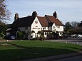
Red Lion Public house, Great Offley
Great Offley High Street, looking north, immediately on the right is the Old Post Office,
Chapel Cottges, Luton Road, Great Offley, (formerly the village Chapel)
View to the north from Luton Road, Great Offley
Looking north towards Offley Hill from Bakers Lane
Looking across the village pond toward the Pump and what is now the Green Man Public House (around 1900)
Local services
The village still has a Post Office/General stores, the butchers shop was closed in recent times to be replaced by an Ladies hairdressers, there had been one previously in the late 1970s located in a property adjoining the butchers shop. There is now a butchers shop at Offley hoo farm which has been there for a few years. The Village Petrol station closed in the late 1980s although a garage operated on the site until 2001 when the land was sold for development.
Offley Endowed JMI School is situated close to the village centre.
Public houses
At one time Great Offley had six pubs in the village, these have now decreased to two with a third being converted into a Chinese Restaurant.
The Bull (now closed and converted into a private dwelling)
The Cock became The Crusty Loaf and then the Lobster Tail restaurant which subsequently closed and has been turned into a private dwelling.
The Gloucester Arms
refurbished and name changed to Prince Henry
further refurbishment and name changed to Shaker Browns
renamed as Astons (Restaurant and Bar)
Reverted to Gloucester Arms
Converted into Chinese Restaurant The Offley Oriental[6]
Recreation
Offley and Stopsley Cricket Club,[7] play at the Recreation Ground.[7]
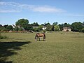
Offley and District Riding Club have at least four shows at the Old Football Field, Luton White Hill.
Luton and District Aeronautical Society fly remote control model aircraft at a field at the top of Chalk Hill to the south east of the village.
There is also a fishing club which uses the Long Pond and the Pump Pond which are located along Salusbury Lane.
Little Offley
Little Offley is a small hamlet lying 1+1⁄2 miles north-west of Great Offley, and it is reached via a bridge over the A505. It contains a late Tudor brick-built manor house.
The Hitchin Yeshiva is based in Wellbury House which is a mile north east of Little Offley.
The Flints
The Flints lies just ½ mile west of Great Offley, and its population is 40.[2]
Cockernhoe
Cockernhoe lies 2+1⁄2 miles south-west of Great Offley, and its population is 191 .[2]
Cockernhoe has a village school and a small church (St Hugh's).
St Hugh's Church, Cockernhoe
White Horse and Water Tower at Tea Green
Blacksmiths at Tea Green
The house and gardens of Offley Chase surrounded by fields and rolling hills
Much of the area between Cockernhoe and the eastern edge of Luton is allocated for development as an eastern extension of Luton for approximately 2,100 homes as part of the North Hertfordshire Local Plan, adopted in 2022.[8] The scheme is opposed by Offley Parish Council,[9] as well as campaign groups including Campaign to Protect Rural England and a local group called Keep East of Luton Green.[10]
Mangrove Green
Mangrove Green lies just north of Cockernhoe and south of Putteridge Bury, and its population is 108.[2] The village has one pub, the King William IV.
Tea Green
Tea Green lies 2+1⁄2 miles south of Great Offley, and its population is 44.[2] Tea Green sits on top of a chalk ridge on the opposite side of Lilley Bottom/Mimram Valley. A major landmark is the tall water tower which is next to the White Horse Pub.
Two of the oldest barns in the area (dating from the 16th century) are located at Tankards and Crutchmore Farms.[11]
Offley Chase
Lies approximately 2 miles south west of Offley along Lilley Bottom.
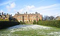
Putteridge Bury belongs to the University of Bedfordshire, previously being used as the Management Campus of the University of Luton, it was originally acquired in 1965 as a teacher training college. The mansion was built in the style of Chequers by architects Sir Ernest George and Alfred Yeats and completed in 1911. The grounds were redesigned by Edwin L Lutyens, soon to be recognised as the foremost architect of the era, and planted by Gertrude Jekyll, one of the first lady Victorian gardeners. Particular features are the reflective pool and massive yew hedges. As well as the mansion house the estate has a farm and a collection of spread out houses.
The Putteridge estate is a mixture of arable farmland and woodland; as well as the occasional visiting muntjac and fallow deer, the estate is home to Lady Amherst's pheasant (Chrysolophus amherstiae) as well as the more common pheasant.
Putteridge Bury House
Lady Amherst's pheasant
Agriculture and wildlife
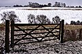
The land use in the parish is a mixture of arable, and woodland with some minor seasonal grazing for beef cattle and sheep. To the east of the village all the round to the south east forms part of the King's Walden estate. During the winter months pheasant and partridge shooting takes with several shooting syndicates operating to the north of the village as well as a big shoot organised by King's Walden Estate.
Many of the farms in the area are no longer used for agriculture and some have been sold off for housing development. The fields being taken over by farms at a greater distance, this has happened due to technological advances which make small farms un-economical to run. Several farms up until the 1970s had herds of dairy cattle but low milk prices forced many farms to turn to arable farming.
Much of the woodland is not used for timber and is made up of oak, beech and horse chestnut trees, with smaller plantations of pine and spruce. During the spring many of the woods are carpeted with bluebells.
The area is home to a sizeable herd of fallow deer and muntjac can also be seen.
There are three tiers of local government covering Offley, at parish, district, and county level: Offley Parish Council, North Hertfordshire District Council, and Hertfordshire County Council.[15] The parish council generally meets alternately at Offley Village Hall and Cockernhoe Memorial Hall.[16]
LM616 received severe damage during the raid, in which its controls and navigation aids were shot up. The aircraft had descended through low cloud only to see the high escarpment of the Chiltern Hills at Offley loom into view too late for the crew to take immediate action. The aircraft hit trees in a wood on top of Birkitt Hill before colliding with the farmhouse at West End Farm.[21][22][23]
Auxiliary Territorial Service (ATS) Search Light Unit
Avro Lancaster
Avro Lancaster in flight
Glebe Farm Explosion
At 3pm on 8 January 1945, a US Army lorry carrying munitions was involved in a road accident with a petrol tanker as it was passing Glebe Farm at the Flints.
The drivers managed to evacuate nearby residents; however, a bus from Luton came round the corner just as an explosion occurred, killing three US servicemen on the bus and injuring 21 others. The explosion was so severe that it made a crater on the road 50 feet wide and 14 feet deep.
The Windmill and Farm were completely destroyed and Flint cottages were severely damaged, other houses in Offley suffered extensive blast damage.[23][24][25]
Population
At the 2021 census, the population of the parish was 1,646.[1] The population had been 1,307 in 2001,[26] and 1,398 in 2011.[27]
References
1 2 "2021 Census Parish Profiles". NOMIS. Office for National Statistics. Retrieved 31 March 2025. (To get individual parish data, use the query function on table PP002.)
This page is based on this Wikipedia article Text is available under the CC BY-SA 4.0 license; additional terms may apply. Images, videos and audio are available under their respective licenses.