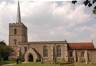
Much Hadham, formerly known as Great Hadham, is a village and civil parish in the district of East Hertfordshire, Hertfordshire, England. The parish of Much Hadham contains the hamlets of Perry Green and Green Tye, as well as the village of Much Hadham itself and Hadham Cross. It covers 4,490 acres (1,820 ha). The village of Much Hadham is situated midway between Ware and Bishop's Stortford. The population of the parish was recorded as 2,087 in the 2011 census, an increase from 1,994 in 2001.

North Hertfordshire is one of ten local government districts in the county of Hertfordshire, England. Its council is based in Letchworth Garden City and the largest town is Hitchin. The district also includes the towns of Baldock and Royston and numerous villages and surrounding rural areas. Part of the district lies within the Chiltern Hills, a designated Area of Outstanding Natural Beauty.

Aldenham is a village and civil parish in the borough of Hertsmere in Hertfordshire, England. The parish includes Radlett and Letchmore Heath as well as Aldenham village itself. The village of Aldenham lies 3.5 miles (5.6 km) north-east of Watford and 2 miles (3.2 km) southwest of Radlett. Aldenham was mentioned in the Domesday Book of 1086, and is one of Hertsmere's 14 conservation areas. The village has eight pre-19th-century listed buildings and the parish itself is largely unchanged, though buildings have been rebuilt, since Saxon times when the majority of the land was owned by the abbots of Westminster Abbey.

Caddington is a village and civil parish in the Central Bedfordshire district of Bedfordshire, England.

Ardeley is a small village and civil parish in East Hertfordshire, England. The parish includes the hamlet of Cromer, as well as Wood End and Moor Green.

Albury is a village and civil parish in the East Hertfordshire district of Hertfordshire, England, about five miles west of Bishop's Stortford. According to the 2001 census it had a population of 537, increasing in the 2011 Census to 595.

Shenley is a village and civil parish in Hertfordshire, England, between Barnet and St Albans. The village is located 14 miles from Central London. As of 2021, the population of the parish was 5,390; however, the parish stretches far beyond the village itself; it is the largest parish in Hertsmere and is very rural, including hamlets and farming settlements such as Dancers Hill, Green Street, Kitts End, Ridge, Saffron Green, Shenleybury, and the largest other settlement, South Mimms.

Little Hallingbury is a small village and a civil parish in the Uttlesford district of Essex, England.

Sandon is a village and civil parish just off junction 17 of the A12 in Essex, England, adjacent to Great Baddow and close to Danbury.

Sandon is a village in the civil parish of Sandon and Burston, in the Stafford district, in the county of Staffordshire, England. It is about 4.5 miles (7 km) northeast of Stafford. The village is in the Trent Valley on the A51 road. On 6 September 1989 the parish was renamed from "Sandon" to "Sandon & Burston".

Wallington is a small village and civil parish in the North Hertfordshire district, in the county of Hertfordshire, England, near the town of Baldock. The population of the civil parish at the 2011 Census was 150. Nearby villages include Rushden and Sandon. It shares a parish council with Rushden.
Cottered is a village and civil parish 3 miles (4.8 km) west of Buntingford and 6 miles (9.7 km) east of Baldock in the East Hertfordshire District of Hertfordshire in England. It had a population of 634 in 2001, increasing to 659 at the 2011 Census.

Hertingfordbury is a small village in Hertfordshire, England, close to the county town of Hertford. It was mentioned in the Domesday Book of 1086. Hertingfordbury is also the name of a neighbouring civil parish, which does not contain the village. Hertingfordbury village is within the Castle ward of Hertford Town Council. The population of the civil parish as of the 2021 census was 689.

Essendon is a village and civil parish in Hertfordshire, England, 6 miles (10 km) south-west of Hertford.

Wareside is a small village and civil parish in the East Hertfordshire district, in the county of Hertfordshire, England. The population of the civil parish in the 2011 census was 735. It is approximately 3 miles (5 km) away from the town of Ware and the larger town of Hertford, the county town. Nearby villages include Widford, Hunsdon, Babbs Green and Bakers End. Nearby hamlets include Cold Christmas and Helham Green. The B1004 road linking Ware to Bishop's Stortford goes through the village and the main A10 road can be joined up at Thundridge. Fanhams Hall Road links Wareside back to Ware. Ware railway station on the Hertford East Branch Line is located two and a half miles (4 km) away.

Great Munden is a village and civil parish in Hertfordshire, England. The parish, in the district of East Hertfordshire, spans 3,758 acres (5.872 sq mi), of which 1,895.75 acres (2.96211 sq mi) are arable land, 927.5 acres (1.4492 sq mi) are permanent grass and 97 acres (0.152 sq mi) are wood. It has a population of 477, reducing to 339 at the 2011 Census, and is situated 6 miles (9.7 km) north of the town of Ware. The village includes the church of St Nicholas, Munden Bury, and a rectory that includes the remains of a moat. Other settlements in the parish include Nasty and Levens Green. A detached portion of Little Munden was added to the parish in 1888.

Little Munden or Munden-Frewell or Munden Parva is a civil parish in the East Hertfordshire district, in the county of Hertfordshire, England. In 2011 the parish had a population of 952.
Sacombe is a village and civil parish in the East Hertfordshire district, of Hertfordshire, England. At the 2001 census it had a population of 165. Sacombe is located about 4 miles N N W of Ware; other nearby settlements include Dane End and Sacombe Green.

Milwich is a village and a civil parish in the English county of Staffordshire.

Chipping is a hamlet in the civil parish of Buckland in the East Hertfordshire district, in the county of Hertfordshire, England. Situated along the A10 road, Chipping was an early, but unsuccessful attempt to create a market town at the crossing of the River Rib by Ermine Street. Situated in a valley, Chipping lies approximately two miles (3.2 km) north of Buntingford and six miles (9.7 km) south of Royston. Chipping is situated half a mile west of the prime meridian. Prior to 1750, Chipping was referred to as New Chipping, today this name is rarely used.

