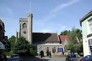
Welwyn is a village and civil parish in Hertfordshire, England. The parish also includes the villages of Digswell and Oaklands. It is sometimes referred to as Old Welwyn or Welwyn Village, to distinguish it from the much newer and larger settlement of Welwyn Garden City, about a mile to the south.
Much Hadham, formerly known as Great Hadham, is a village and civil parish in the district of East Hertfordshire, Hertfordshire, England. The parish of Much Hadham contains the hamlets of Perry Green and Green Tye, as well as the village of Much Hadham itself and Hadham Cross. It covers 4,490 acres (1,820 ha). The village of Much Hadham is situated midway between Ware and Bishop's Stortford. The population of the parish was recorded as 2,087 in the 2011 census, an increase from 1,994 in 2001.

Bayfordbury, Hertfordshire, is a large Grade II* listed country house with surrounding parkland, and the location of a University of Hertfordshire campus, housing its biology/geography field station and observatory.
Chorleywood is both a village and a civil parish in the Three Rivers District, Hertfordshire, on the border with Buckinghamshire, approximately 20 miles (32 km) northwest of Charing Cross. The village is adjacent to the Chiltern Hills Area of Outstanding Natural Beauty and is part of the London commuter belt included in the government-defined Greater London Urban Area. Chorleywood was historically part of the parish of Rickmansworth, becoming a separate ecclesiastical parish in 1845 and a separate civil parish in 1898. The population of the parish was 11,286 at the 2011 census.
Waltham Cross is a town in the Borough of Broxbourne, Hertfordshire, England, located 12 miles (19 km) north of central London. In the south-eastern corner of Hertfordshire, it borders Cheshunt to the north, Waltham Abbey to the east, and Enfield to the south.

Kimpton is a village in Hertfordshire, England, six miles south of Hitchin, seven miles north of St Albans and four miles from Harpenden and Luton. The population at the 2011 Census was 2,167.

Graveley is a village and civil parish about four miles east of Hitchin and two miles north of Stevenage in Hertfordshire, England. The population of the parish in the 2011 census was 487. A milestone in the village states that it is 33 miles from London.

Aston is a village and civil parish in the East Hertfordshire district of Hertfordshire, England. According to the 2001 census it had a population of 844, increasing to 871 at the 2011 Census. Located on a ridge between Stevenage and the Beane Valley, Aston is a 10 minutes drive from the A1(M).

Benington is a village and civil parish in the East Hertfordshire district of Hertfordshire, England, about four miles east of Stevenage and 35 miles north of London.

Bygrave is a village and civil parish in the North Hertfordshire district of Hertfordshire, England, about 2 miles north-east of Baldock. In the 10th century the parish was called Bigraffan and 11th to 16th centuries Bigrave. According to the 2011 census it had a population of 306. A reservoir is situated behind the Old Rectory and used for irrigation of potato crops by Manor Farm.

Shenley is a village and civil parish in Hertfordshire, England, between Barnet and St Albans. The village is located 14 miles from Central London. As of 2021, the population of the parish was 5,390; however, the parish stretches far beyond the village itself; it is the largest parish in Hertsmere and is very rural, including hamlets and farming settlements such as Dancers Hill, Green Street, Kitts End, Ridge, Saffron Green, Shenleybury, and the largest other settlement, South Mimms.

Digswell is an ancient village and former parish in the English county of Hertfordshire which is recorded in the 1086 Domesday Book. The population of the urban area of Digswell in the 2011 Census was 1,632.

Hertford Heath is a village and civil parish near the county town of Hertford in Hertfordshire, England. The population at the 2011 Census was 2,672.
Great Amwell is a village and civil parish in the East Hertfordshire district, in the county of Hertfordshire, England. It is 1+1⁄2 miles (2.4 km) southeast of Ware and about 20 miles (32 km) north of London. In 2011 the parish had a population of 2353.
Brickendon is a village in the civil parish of Brickendon Liberty in the district of East Hertfordshire about 3 miles (4.8 km) south of the county town Hertford, and is served by Bayford railway station.
Cottered is a village and civil parish 3 miles (4.8 km) west of Buntingford and 6 miles (9.7 km) east of Baldock in the East Hertfordshire District of Hertfordshire in England. It had a population of 634 in 2001, increasing to 659 at the 2011 Census.

Hertingfordbury is a small village in Hertfordshire, England, close to the county town of Hertford. It was mentioned in the Domesday Book of 1086. Hertingfordbury is also the name of a neighbouring civil parish, which does not contain the village. Hertingfordbury village is within the Castle ward of local government Hertford Town Council. The population of the civil parish as of the 2021 census was 689.

Wareside is a small village and civil parish in the East Hertfordshire district, in the county of Hertfordshire, England. The population of the civil parish in the 2011 census was 735. It is approximately 3 miles (5 km) away from the town of Ware and the larger town of Hertford, the county town. Nearby villages include Widford, Hunsdon, Babbs Green and Bakers End. Nearby hamlets include Cold Christmas and Helham Green. The B1004 road linking Ware to Bishop's Stortford goes through the village and the main A10 road can be joined up at Thundridge. Fanhams Hall Road links Wareside back to Ware. Ware railway station on the Hertford East Branch Line is located two and a half miles (4 km) away.

Gilston is a village and civil parish in the East Hertfordshire district of Hertfordshire, England. It is located a little over one mile north of the town of Harlow in the neighbouring county of Essex. Together with the nearby village of Eastwick, it forms the parish council of Eastwick and Gilston Parish Council. It is within the Hunsdon ward of East Hertfordshire District Council. At the 2001 Census, the population was 180, and 228 at the 2011 Census.

Chipping is a hamlet in the civil parish of Buckland in the East Hertfordshire district, in the county of Hertfordshire, England. Situated along the A10 road, Chipping was an early, but unsuccessful attempt to create a market town at the crossing of the River Rib by Ermine Street. Situated in a valley, Chipping lies approximately two miles (3.2 km) north of Buntingford and six miles (9.7 km) south of Royston. Chipping is situated half a mile west of the prime meridian. Prior to 1750, Chipping was referred to as New Chipping, today this name is rarely used.
