List of lost settlements in Hertfordshire

Last updated

Where current settlements are listed they are not the same as the disappeared villages. For example, Stevenage relocated to be closer to the Great North Road, abandoning the previous Stevenage.

Contents

II denotes any change in position

Village or hamlet [1] Parish or HundredCoordinates
Aldwick Tring 51°50′56″N0°42′15″W / 51.848959°N 0.704143°W / 51.848959; -0.704143 (Aldwick)
Alfledawich (Beauchamps)Layston with Buntingford 51°57′50″N0°00′45″E / 51.963885°N 0.012495°E / 51.963885; 0.012495 (Alfledawich)
AlswickLayston with Buntingford 51°56′49″N0°00′11″W / 51.94696°N 0.003006°W / 51.94696; -0.003006 (Alswick)
Aspenden II Aspenden 51°56′29″N0°02′22″W / 51.941379°N 0.039441°W / 51.941379; -0.039441 (Aspenden II)
Ayot St Lawrence Ayot St Lawrence 51°50′17″N0°15′58″W / 51.837921°N 0.266054°W / 51.837921; -0.266054 (Ayot St Lawrence)
Ayot St Peter Ayot St Peter 51°49′13″N0°13′55″W / 51.820325°N 0.231902°W / 51.820325; -0.231902 (Ayot St Peter)
Berkeden (Berkesdon Green) Aspenden 51°55′51″N0°03′26″W / 51.930885°N 0.057355°W / 51.930885; -0.057355 (Berkeden)
Betlow Tring 51°50′46″N0°41′49″W / 51.846182°N 0.696963°W / 51.846182; -0.696963 (Betlow)
Bordesden (Bozen Green) Braughing 51°55′31″N0°03′16″W / 51.925389°N 0.05441°W / 51.925389; -0.05441 (Bordesden)
Boxbury Walkern 51°55′24″N0°08′47″W / 51.923328°N 0.146406°W / 51.923328; -0.146406 (Boxbury)
Bricewold Hertford Hundred Unlocated
Brickendon Brickendon 51°46′38″N0°04′16″W / 51.777329°N 0.071208°W / 51.777329; -0.071208 (Brickendon)
Broadfield Cottered 51°57′42″N0°04′14″W / 51.961679°N 0.070581°W / 51.961679; -0.070581 (Broadfield)
Broadmead Tring 51°50′56″N0°42′15″W / 51.848959°N 0.704143°W / 51.848959; -0.704143 (Broadmead)
Burston St Stephens 51°43′14″N0°21′22″W / 51.720505°N 0.355979°W / 51.720505; -0.355979 (Burston)
Caldecote Caldecote 52°01′52″N0°11′45″W / 52.031112°N 0.195896°W / 52.031112; -0.195896 (Caldecote)
Chaldean Much Hadham 51°51′54″N0°04′03″E / 51.864903°N 0.067632°E / 51.864903; 0.067632 (Chaldean)
Chesfield Graveley 51°56′05″N0°11′07″W / 51.934724°N 0.185217°W / 51.934724; -0.185217 (Chesfield)
ChildwickSt. Michaels, St. Albans 51°47′00″N0°20′42″W / 51.783302°N 0.344997°W / 51.783302; -0.344997 (Childwick)
Cockenach Barkway 51°57′10″N0°01′57″E / 51.952752°N 0.032373°E / 51.952752; 0.032373 (Cockenach)
Cockhamsted Braughing 51°54′29″N0°03′50″E / 51.908138°N 0.063801°E / 51.908138; 0.063801 (Cockhamsted)
Corney Bury Wyddial 51°57′29″N0°01′22″W / 51.958186°N 0.022695°W / 51.958186; -0.022695 (Corney Bury)
Digswell Digswell 51°49′09″N0°12′21″W / 51.819031°N 0.205833°W / 51.819031; -0.205833 (Digswell)
Flaunden Flaunden 51°41′59″N0°31′45″W / 51.699853°N 0.529232°W / 51.699853; -0.529232 (Flaunden)
Flexmere Kings Walden 51°53′16″N0°18′07″W / 51.887905°N 0.301917°W / 51.887905; -0.301917 (Flexmere)
Gilston Gilston 51°48′06″N0°05′22″E / 51.801564°N 0.089392°E / 51.801564; 0.089392 (Gilston)
Great Munden Great Munden 51°54′03″N0°01′46″W / 51.900746°N 0.02958°W / 51.900746; -0.02958 (Great Munden)
Gubblecote Tring 51°49′41″N0°41′09″W / 51.828074°N 0.685876°W / 51.828074; -0.685876 (Gubblecote)
Hainstone Odsey Hundred (? near Hinxworth)Unlocated
Hanstead St Stephens 51°42′09″N0°20′42″W / 51.702366°N 0.345057°W / 51.702366; -0.345057 (Hanstead)
Hixham Furneux Pelham 51°55′15″N0°06′55″E / 51.920713°N 0.115284°E / 51.920713; 0.115284 (Hixham)
Hodenhoe Therfield 51°58′58″N0°02′21″W / 51.982742°N 0.039091°W / 51.982742; -0.039091 (Hodenhoe)
Ichetone (Layston)Layston with Buntingford 51°57′06″N0°00′20″W / 51.951601°N 0.00552°W / 51.951601; -0.00552 (Ichetone)
Kitts End South Mymms 51°40′17″N0°12′07″W / 51.671284°N 0.201927°W / 51.671284; -0.201927 (Kitts End)
Lewarewich (Leverage) Much Hadham/Widford near 51°49′43″N0°05′00″E / 51.828651°N 0.083388°E / 51.828651; 0.083388 (Lewarewich)
Libury (Stutereshele) Little Munden 51°53′38″N0°02′40″W / 51.893799°N 0.04442°W / 51.893799; -0.04442 (Libury)
Mardley Welwyn 51°51′03″N0°10′16″W / 51.850872°N 0.171167°W / 51.850872; -0.171167 (Mardley)
Maydencroft (Furnival Dinsley) St Ippolyts 51°55′57″N0°16′48″W / 51.932549°N 0.279865°W / 51.932549; -0.279865 (Maydencroft)
Minsden Langley 51°54′25″N0°15′27″W / 51.907041°N 0.257577°W / 51.907041; -0.257577 (Minsden)
Miswell Tring 51°47′57″N0°40′36″W / 51.799193°N 0.676563°W / 51.799193; -0.676563 (Miswell)
Moor Green Ardeley 51°55′20″N0°04′41″W / 51.922232°N 0.078092°W / 51.922232; -0.078092 (Moor Green)
Napsbury St. Peter Rural 51°43′31″N0°18′45″W / 51.725283°N 0.312363°W / 51.725283; -0.312363 (Napsbury)
Nettleden II Nettleden 51°46′59″N0°31′40″W / 51.783035°N 0.527696°W / 51.783035; -0.527696 (Nettleden II)
Newsells Barkway 52°00′57″N0°01′14″E / 52.015905°N 0.02066°E / 52.015905; 0.02066 (Newsells)
North Mymms North Mymms 51°43′33″N0°13′47″W / 51.725866°N 0.229798°W / 51.725866; -0.229798 (North Mymms)
Oxwich Broadwater Hundred near Codicote
Pendley Tring 51°47′45″N0°37′49″W / 51.795965°N 0.630247°W / 51.795965; -0.630247 (Pendley)
Plashes Standon 51°51′51″N0°00′29″E / 51.864137°N 0.008039°E / 51.864137; 0.008039 (Plashes)
Queenhoo Tewin 51°49′47″N0°08′40″W / 51.829769°N 0.144445°W / 51.829769; -0.144445 (Queenhoo)
Quickswood Clothall 51°58′44″N0°08′18″W / 51.978956°N 0.138285°W / 51.978956; -0.138285 (Quickswood)
Rodenhanger Norton 51°59′22″N0°12′32″W / 51.989472°N 0.208944°W / 51.989472; -0.208944 (Rodenhanger)
Sapeham Edwinstree Hundred Unlocated
Stagenhoe St Paul's Walden 51°53′25″N0°16′32″W / 51.890221°N 0.275669°W / 51.890221; -0.275669 (Stagenhoe)
Stanstead Abbots Stanstead Abbots 51°46′49″N0°01′44″E / 51.780139°N 0.028955°E / 51.780139; 0.028955 (Stanstead Abbots)
Stevenage Stevenage 51°55′14″N0°11′45″W / 51.920501°N 0.195972°W / 51.920501; -0.195972 (Stevenage)
Stivicesworde Hertford Hundred Unlocated
Stocks Aldbury 51°48′36″N0°36′13″W / 51.810041°N 0.603707°W / 51.810041; -0.603707 (Stocks)
Stonebury Little Hormead 51°56′06″N0°00′51″E / 51.935079°N 0.014116°E / 51.935079; 0.014116 (Stonebury)
Temple Dinsley Preston 51°54′33″N0°16′51″W / 51.90918°N 0.280758°W / 51.90918; -0.280758 (Temple Dinsley)
Thorley Thorley 51°50′54″N0°08′38″E / 51.848249°N 0.14383°E / 51.848249; 0.14383 (Thorley)
Throcking Throcking 51°57′18″N0°03′12″W / 51.955101°N 0.053397°W / 51.955101; -0.053397 (Throcking)
Thundridge Thundridge 51°50′22″N0°00′48″W / 51.839319°N 0.013391°W / 51.839319; -0.013391 (Thundridge)
Tiscott Tring 51°51′06″N0°43′02″W / 51.851799°N 0.71713°W / 51.851799; -0.71713 (Tiscott)
Titburst (Theobald Street) Aldenham
Wakeley Westmill 51°55′28″N0°02′51″W / 51.924426°N 0.047452°W / 51.924426; -0.047452 (Wakeley)
Wandon St Paul's Walden 51°53′22″N0°21′15″W / 51.889547°N 0.354176°W / 51.889547; -0.354176 (Wandon)
Wellbury Offley 51°57′18″N0°20′14″W / 51.954956°N 0.337227°W / 51.954956; -0.337227 (Wellbury)
Welei (Wain Wood) Hitchin Half-Hundred (in Ippollitts)Unlocated
Wickham Bishops Stortford 51°53′10″N0°08′39″E / 51.886016°N 0.144174°E / 51.886016; 0.144174 (Wickham)
WindridgeSt. Michaels, St. Albans 51°44′19″N0°22′11″W / 51.738684°N 0.369804°W / 51.738684; -0.369804 (Windridge)
Wollenwick (Woolwicks) Stevenage 51°54′46″N0°13′21″W / 51.912811°N 0.222455°W / 51.912811; -0.222455 (Wollenwick)

Reasons for desertion

Related Research Articles

<span class="mw-page-title-main">Famine</span> Widespread scarcity of food

A famine is a widespread scarcity of food, caused by several factors including war, natural disasters, crop failure, widespread poverty, an economic catastrophe or government policies. This phenomenon is usually accompanied or followed by regional malnutrition, starvation, epidemic, and increased mortality. Every inhabited continent in the world has experienced a period of famine throughout history. During the 19th and 20th century, Southeast and South Asia, as well as Eastern and Central Europe, suffered the greatest number of fatalities. Deaths caused by famine declined sharply beginning in the 1970s, with numbers falling further since 2000. Since 2010, Africa has been the most affected continent in the world by famine.

<span class="mw-page-title-main">British Agricultural Revolution</span> Mid-17th to 19th century revolution centred around agriculture

The British Agricultural Revolution, or Second Agricultural Revolution, was an unprecedented increase in agricultural production in Britain arising from increases in labour and land productivity between the mid-17th and late 19th centuries. Agricultural output grew faster than the population over the hundred-year period ending in 1770, and thereafter productivity remained among the highest in the world. This increase in the food supply contributed to the rapid growth of population in England and Wales, from 5.5 million in 1700 to over 9 million by 1801, though domestic production gave way increasingly to food imports in the 19th century as the population more than tripled to over 35 million. Using 1700 as a base year (=100), agricultural output per agricultural worker in Britain steadily increased from about 50 in 1500, to around 65 in 1550, to 90 in 1600, to over 100 by 1650, to over 150 by 1750, rapidly increasing to over 250 by 1850. The rise in productivity accelerated the decline of the agricultural share of the labour force, adding to the urban workforce on which industrialization depended: the Agricultural Revolution has therefore been cited as a cause of the Industrial Revolution.

<span class="mw-page-title-main">Transhumance</span> Type of pastoralism

Transhumance is a type of pastoralism or nomadism, a seasonal movement of livestock between fixed summer and winter pastures. In montane regions, it implies movement between higher pastures in summer and lower valleys in winter. Herders have a permanent home, typically in valleys. Generally only the herds travel, with a certain number of people necessary to tend them, while the main population stays at the base. In contrast, horizontal transhumance is more susceptible to being disrupted by climatic, economic, or political change.

<span class="mw-page-title-main">Stevenage</span> Town and borough in Hertfordshire, England

Stevenage is a large town and borough in Hertfordshire, England, about 27 miles (43 km) north of London. Stevenage is east of junctions 7 and 8 of the A1(M), between Letchworth Garden City to the north and Welwyn Garden City to the south. In 1946, Stevenage was designated the United Kingdom's first New Town under the New Towns Act.

<span class="mw-page-title-main">Drovers' road</span> Route for driving livestock on foot

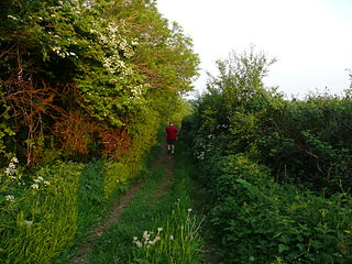
A drovers' road, drove road, droveway, or simply a drove, is a route for droving livestock on foot from one place to another, such as to market or between summer and winter pasture. Many drovers' roads were ancient routes of unknown age; others are known to date back to medieval or more recent times.

<span class="mw-page-title-main">Great Famine of 1315–1317</span> Famine of medieval Europe

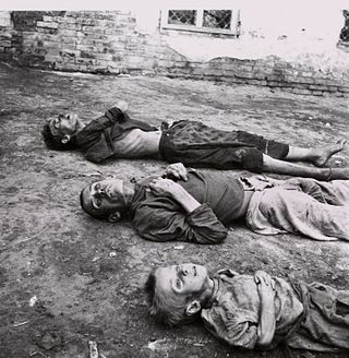
The Great Famine of 1315–1317 was the first of a series of large-scale crises that struck Europe early in the 14th century. Most of Europe was affected. The famine caused many deaths over an extended number of years and marked a clear end to the period of growth and prosperity from the 11th to the 13th centuries.

<span class="mw-page-title-main">Medieval demography</span> Human demography in Europe and the Mediterranean during the Middle Ages

Medieval demography is the study of human demography in Europe and the Mediterranean during the Middle Ages. It estimates and seeks to explain the number of people who were alive during the Medieval period, population trends, life expectancy, family structure, and related issues. Demography is considered a crucial element of historical change throughout the Middle Ages.

<span class="mw-page-title-main">Abandoned village</span> Village that has been deserted

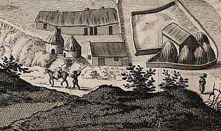
An abandoned village is a village that has, for some reason, been deserted. In many countries, and throughout history, thousands of villages have been deserted for a variety of causes. Abandonment of villages is often related to epidemic, famine, war, climate change, economic depressions, environmental destruction, or deliberate clearances.

<span class="mw-page-title-main">Cottenham</span> Human settlement in England

Cottenham is a village in Cambridgeshire, England. Cottenham is one of the larger villages surrounding the city of Cambridge, located around five miles north of the city. The population of the civil parish at the 2011 Census was 6095. Cottenham is one of a number of villages that make up the historical Fen Edge region in between Cambridge and Ely, which were originally settlements on the shore of the marshes close to the city of Cambridge, then an inland port.

<span class="mw-page-title-main">Shephall</span> Human settlement in England

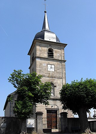
Shephall is a neighbourhood of the new town of Stevenage in Hertfordshire. It was formerly a separate village and parish, being absorbed into Stevenage in 1953.

<span class="mw-page-title-main">Finger Lakes National Forest</span>

The Finger Lakes National Forest is a United States National Forest that encompasses 16,259 acres (65.80 km2) of Seneca and Schuyler counties, nestled between Seneca Lake and Cayuga Lake in the Finger Lakes Region of the State of New York. It has over 30 miles (50 km) of interconnecting trails that traverse gorges, ravines, pastures, and woodlands.

<span class="mw-page-title-main">Crisis of the Late Middle Ages</span> Events in the 1300s and 1400s which ended centuries of stability in Europe

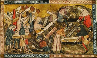
The Crisis of the Late Middle Ages was a series of events in the 14th and 15th centuries that ended centuries of European stability during the Late Middle Ages. Three major crises led to radical changes in all areas of society: demographic collapse, political instability, and religious upheavals.

<span class="mw-page-title-main">La Neuveville-sous-Châtenois</span> Commune in Grand Est, France

La Neuveville-sous-Châtenois is a commune in the Vosges department in Grand Est in northeastern France.

<span class="mw-page-title-main">Economic history of Europe (1000 AD–present)</span>

This article covers the Economic history of Europe from about 1000 AD to the present. For the context, see History of Europe.

<span class="mw-page-title-main">Economy of England in the Middle Ages</span> Overview of the economy of England during the Middle Ages

The medieval English saw their economy as comprising three groups – the clergy, who prayed; the knights, who fought; and the peasants, who worked the landtowns involved in international trade. Over the five centuries of the Middle Ages, the English economy would at first grow and then suffer an acute crisis, resulting in significant political and economic change. Despite economic dislocation in urban and extraction economies, including shifts in the holders of wealth and the location of these economies, the economic output of towns and mines developed and intensified over the period. By the end of the period, England had a weak government, by later standards, overseeing an economy dominated by rented farms controlled by gentry, and a thriving community of indigenous English merchants and corporations.

<span class="mw-page-title-main">Economics of English agriculture in the Middle Ages</span> Aspect of history

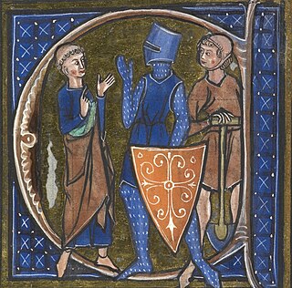
The economics of English agriculture in the Middle Ages is the economic history of English agriculture from the Norman invasion in 1066, to the death of Henry VII in 1509. England's economy was fundamentally agricultural throughout the period, though even before the invasion the market economy was important to producers. Norman institutions, including serfdom, were superimposed on an existing system of open fields.

The Economics of English Mining in the Middle Ages is the economic history of English mining from the Norman invasion in 1066, to the death of Henry VII in 1509. England's economy was fundamentally agricultural throughout the period, but the mining of iron, tin, lead and silver, and later coal, played an important part within the English medieval economy.

<span class="mw-page-title-main">Vácrátót</span> Village in Central Hungary, Hungary

Vácrátót is a village and commune in the comitatus of Pest in Hungary.

<span class="mw-page-title-main">Agriculture in Scotland in the early modern era</span>

Agriculture in Scotland in the early modern era includes all forms of farm production in the modern boundaries of Scotland, between the establishment of the Renaissance in the early sixteenth century and the beginning of the Industrial Revolution in the mid-eighteenth century. This era saw the impact of the Little Ice Age, which peaked towards the end of the seventeenth century. Almost half the years in the second half of the sixteenth century saw local or national scarcity, necessitating the shipping of large quantities of grain from the Baltic. In the early seventeenth century famine was relatively common, but became rarer as the century progressed. The closing decade of the seventeenth century saw a slump, followed by four years of failed harvests, in what is known as the "seven ill years", but these shortages would be the last of their kind.

<span class="mw-page-title-main">Agriculture in the Middle Ages</span> Farming practices, crops, technology, and socioeconomics

Agriculture in the Middle Ages describes the farming practices, crops, technology, and agricultural society and economy of Europe from the fall of the Western Roman Empire in 476 to approximately 1500. The Middle Ages are sometimes called the Medieval Age or Period. The Middle Ages are also divided into the Early, High, and Late Middle Ages. The early modern period followed the Middle Ages.

References

  1. The Deserted Medieval Villages Of Hertfordshire 2nd Ed 1982- K. Rutherford Davis ISBN   0-901354-23-6
Map all coordinates using: OpenStreetMap  
Download coordinates as: KML