
Ashridge Commons and Woods is a 640.1 hectare biological Site of Special Scientific Interest in Buckinghamshire and Hertfordshire. It is located in Little Gaddesden, and is part of the National Trust Ashridge Estate in the Chilterns Area of Outstanding Natural Beauty.

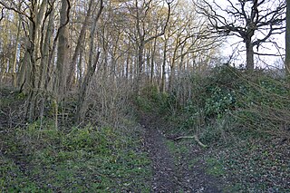
Wain Wood is an ancient woodland extending to 19.2 hectares near Preston in North Hertfordshire. The site is a Site of Special Scientific Interest which was notified in 1986 under the Wildlife and Countryside Act 1981. The local planning authority is North Hertfordshire District Council. It is a relic of a large forest which extended from Hitchin to Hatfield.

Wormley-Hoddesdonpark Wood South is a 192.5 hectares is a biological site of Special Scientific Interest near Cheshunt in Hertfordshire. It is part of Broxbourne Woods National Nature Reserve, and is listed in A Nature Conservation Review. Wormley Wood is owned and managed by the Woodland Trust. The site is also a Special Area of Conservation.

Wormley-Hoddesdonpark Wood North is a 143.9-hectare (356-acre) woodland area in Hertfordshire which has been designated as a biological site of Special Scientific Interest. The site is listed as Grade 1 in A Nature Conservation Review, and is also designated a Special Area of Conservation. It is in Hoddesdon in the borough of Broxbourne, but part of the site is in East Hertfordshire.

Bream Wood is a 7.8-hectare (19-acre) biological Site of Special Scientific Interest north of Crowborough in East Sussex.

Bricket Wood Common is a 70 hectare open space and biological Site of Special Scientific Interest in Bricket Wood in Hertfordshire. It is managed by St Albans City and District Council together with the Countryside Management Service and Bricket Wood Joint Management Committee.

Hunsdon Mead is a 34 hectare biological Site of Special Scientific Interest (SSSI) west of Harlow and east of Roydon in Essex. The site is partly in Essex and partly in Hertfordshire, and it is jointly owned and managed by the Essex Wildlife Trust and the Herts and Middlesex Wildlife Trust. The SSSI also includes part of the neighbouring Roydon Mead. The planning authorities are East Hertfordshire District Council and Epping Forest District Council. Hunsdon Mead is registered common land.

Northaw Great Wood is a 223.6-hectare (553-acre) biological Site of Special Scientific Interest (SSSI) near Cuffley in Hertfordshire, England. It covers Northaw Great Wood Country Park, which is managed by Welwyn Hatfield Borough Council, Well Wood, Justice Hill and Grimes Bottom. Part of the site is managed by Hertfordshire County Council as a schools' park. The country park is also a local nature reserve.

Sawbridgeworth Marsh is a 6.3-hectare (16-acre) biological Site of Special Scientific Interest (SSSI) near Sawbridgeworth in Hertfordshire, apart from a small area in the north which is in Essex. It is managed by the Essex Wildlife Trust. The planning authorities are East Hertfordshire District Council and Uttlesford District Council.
Benington High Wood is a 20.7-hectare (51-acre) biological Site of Special Scientific Interest in Benington, Hertfordshire. The planning authority is East Hertfordshire District Council.

Knebworth Woods is a 120.8-hectare (299-acre) biological Site of Special Scientific Interest in Knebworth, immediately south of Stevenage in Hertfordshire. The planning authority is North Hertfordshire District Council.

Moor Hall Meadows is a 24.4-hectare (60-acre) biological Site of Special Scientific Interest in Moor Green in Hertfordshire. The local planning authority is East Hertfordshire District Council.

Tring Woodlands is a 23.8-hectare (59-acre) biological Site of Special Scientific Interest in Tring in Hertfordshire. It is part of the Chilterns Area of Outstanding Natural Beauty and the local planning authority is Dacorum District Council. The wood has a rich flora, showing that it is well established. It is a good example of a semi-natural beech wood in Hertfordshire. Plants that are abundant include woodruff, wood anemone and dog's mercury, and there are a variety of woodland birds. There is access to the wood from Hastoe Hill.

Redwell Wood is a 52.8-hectare (130-acre) biological Site of Special Scientific Interest near South Mimms in Hertfordshire. The local planning authority is Welwyn Hatfield District Council.

Hertford Heath nature reserve is a 28 hectare biological Site of Special Scientific Interest in Hertford Heath in Hertfordshire. It is managed by the Herts and Middlesex Wildlife Trust and the local planning authority is East Hertfordshire District Council.

Great Hormead Park is a 15 hectare biological Site of Special Scientific Interest near Great Hormead in Hertfordshire. The local planning authority is East Hertfordshire District Council.
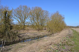
Thorley Wash or Thorley Flood Pound is a 17.3-hectare biological Site of Special Scientific Interest in Thorley, south of Bishop's Stortford in Hertfordshire. It was formerly a flood pound for the Stort Navigation, which was decommissioned in 2004 and converted to a more natural state. It was purchased by the Herts and Middlesex Wildlife Trust from the Environment Agency in 2011.
Millfield Wood is a 9.5-hectare (23-acre) biological Site of Special Scientific Interest north of High Wycombe in Buckinghamshire. It is owned and managed by the Berkshire, Buckinghamshire and Oxfordshire Wildlife Trust, and it is in the Chilterns Areas of Outstanding Natural Beauty.
