
Westmill is a residential area of Hitchin in Hertfordshire, England. It was originally built as a council housing estate in the 1920s. There is a primary school, Oughton Junior, Infant and Nursery School. It forms part of Oughton ward for local government purposes.

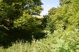
Wain Wood is an ancient woodland extending to 19.2 hectares near Preston in North Hertfordshire. The site is a Site of Special Scientific Interest which was notified in 1986 under the Wildlife and Countryside Act 1981. The local planning authority is North Hertfordshire District Council. It is a relic of a large forest which extended from Hitchin to Hatfield.

Sheepleas is a 99.9-hectare (247-acre) biological and geological Site of Special Scientific Interest east of Guildford in Surrey. It is a Geological Conservation Review site and a Local Nature Reserve. It is owned by Surrey County Council and managed by the Surrey Wildlife Trust.

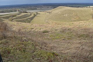
Pegsdon Hills and Hoo Bit is a 79-hectare (200-acre) nature reserve in Pegsdon in Bedfordshire. It is managed by the Wildlife Trust for Bedfordshire, Cambridgeshire and Northamptonshire. The site is on the border between Bedfordshire and Hertfordshire, and it covers Pegsdon Hills and part of the adjacent Deacon Hill in Bedfordshire, and Hoo Bit in Hertfordshire. It is in the Chilterns Area of Outstanding Natural Beauty, and part of the site is designated by Natural England as the Deacon Hill SSSI.

Wormley-Hoddesdonpark Wood South is a 192.5 hectare is a biological site of Special Scientific Interest near Cheshunt in Hertfordshire. It is part of Broxbourne Woods National Nature Reserve, and is listed in A Nature Conservation Review. Wormley Wood is owned and managed by the Woodland Trust. The site is also a Special Area of Conservation.

Westwood Quarry is a 0.07 hectare geological site of Special Scientific Interest west of Watford in Hertfordshire. It was notified in 1987 under the Wildlife and Countryside Act 1981. The planning authority is Three Rivers District Council. It is a Geological Conservation Review site.

Herts and Middlesex Wildlife Trust manages over 40 nature reserves covering nearly 810 hectares north of London, in Hertfordshire and the historic county of Middlesex, part of which is divided between the London boroughs of Barnet, Enfield, Harrow and Hillingdon. It has over 21,000 members, and is one of 46 Wildlife Trusts across the UK. It is a Registered Charity, with its Registered Office in St Albans, and had an income in the year to 31 March 2014 of over £1.5 million.
Knocking Hoe is a 7.7 hectare National Nature Reserve and biological Site of Special Scientific Interest near Pegsdon in Bedfordshire. It is mentioned in A Nature Conservation Review. It is part of the Chilterns Area of Outstanding Natural Beauty, and is managed by Natural England.

Moor Mill Quarry, West is a 0.16-hectare (0.40-acre) geological Site of Special Scientific Interest in How Wood in Hertfordshire. The local planning authority is St Albans City and District Council. It was notified in 1992 as representing the former Moor Mill Quarry SSSI, which was lost to landfill operations. It is listed by the Geological Conservation Review.

Redwell Wood is a 52.8-hectare (130-acre) biological Site of Special Scientific Interest near South Mimms in Hertfordshire. The local planning authority is Welwyn Hatfield District Council.

Downfield Pit is a 3.6-hectare (8.9-acre) geological Site of Special Scientific Interest near Ware in Hertfordshire. It is in the Geological Conservation Review in the Thames Pleistocene section, and the local planning authority is East Hertfordshire District Council.
Oughtonhead Common is a 17.4 hectare Local Nature Reserve in the Westmill district of Hitchin, Hertfordshire. It is owned and managed by North Hertfordshire District Council.

Hillcollins Pit or Furneux Pelham Gravel Pit is a 0.2-hectare (0.49-acre) geological Site of Special Scientific Interest near Furneux Pelham in Hertfordshire. The local planning authority is East Hertfordshire District Council. it was identified as a site of national importance in the Geological Conservation Review in 1988.

Little Heath Pit is a 0.3-hectare (0.74-acre) geological Site of Special Scientific Interest at Little Heath near Potten End in Hertfordshire. It is part of the Ashridge Estate, owned by the National Trust, and the local planning authority is Dacorum Borough Council. It is listed in the Geological Conservation Review.

Purwell Meadows is an 8.6-hectare (21-acre) nature reserve in Hitchin, Hertfordshire, England. It was declared a Local Nature Reserve in 1994. It is owned and managed by North Hertfordshire District Council.
Hill End Pit is a 0.7-hectare (1.7-acre) nature reserve on the site of a former chalk pit, in St Paul's Walden in North Hertfordshire. It was formerly managed by the Herts and Middlesex Wildlife Trust (HMWT). In February 2016 HMWT announced that three sites, Barkway Chalk Pit, Hill End Pit and Pryor's Wood, which HMWT managed on behalf of their owner, North Hertfordshire District Council, were to return to Council management as the Trust was no longer able to meet the cost. It has the largest colony of Azeca goodalli snails in Hertfordshire. Plants include viper's bugloss, cowslip and marjoram, there are butterflies such as common blue and gatekeeper, and many birds including woodpeckers.

Spot Lane Quarry is a 0.1-hectare (0.25-acre) geological Site of Special Scientific Interest on the eastern outskirts of Maidstone in Kent. It is a Geological Conservation Review site.

Freshfield Lane is a 17-hectare (42-acre) geological Site of Special Scientific Interest east of Haywards Heath in West Sussex. It is a Geological Conservation Review site.
