Bricket Wood Common

Last updated
Bricket Wood Common
Site of Special Scientific Interest

Bricket Wood Common 4.JPG

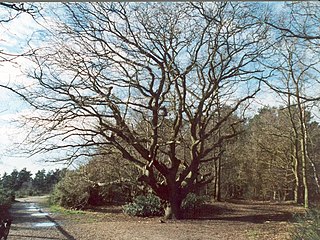
Path in Bricket Wood Common
Area of Search Hertfordshire
Grid reference TL385105
Interest Biological
Area 70.0 hectares
Notification 1984
Location map Magic Map

Bricket Wood Common is a 70 hectare open space and biological Site of Special Scientific Interest in Bricket Wood in Hertfordshire. [1] [2] It is managed by St Albans City and District Council together with the Countryside Management Service and Bricket Wood Joint Management Committee. [3]

Site of Special Scientific Interest Conservation designation denoting a protected area in the United Kingdom

A Site of Special Scientific Interest (SSSI) in Great Britain or an Area of Special Scientific Interest (ASSI) in the Isle of Man and Northern Ireland is a conservation designation denoting a protected area in the United Kingdom and Isle of Man. SSSI/ASSIs are the basic building block of site-based nature conservation legislation and most other legal nature/geological conservation designations in the United Kingdom are based upon them, including national nature reserves, Ramsar sites, Special Protection Areas, and Special Areas of Conservation. The acronym "SSSI" is often pronounced "triple-S I".

Bricket Wood village in the county of Hertfordshire, England

Bricket Wood is a village in the county of Hertfordshire, England, 4.2 miles (6.8 km) south of St Albans and 4.2 miles (6.8 km) north-northeast of Watford.

Hertfordshire County of England

Hertfordshire is one of the home counties in England. It is bordered by Bedfordshire to the north, Cambridgeshire to the north-east, Essex to the east, Buckinghamshire to the west and Greater London to the south. For government statistical purposes, it is placed in the East of England region.

The common is a remnant of a lowland heath, with much it on the heavy soils of boulder clay with poor drainage and wet habitats. There are also areas of ancient woodland and dry heath. The woodland canopy is mainly oak and silver birch with a shrub layer of hornbeam and hazel. Lowland heath flora include sphagnum in the wetter areas and there are several small ponds. In drier heath areas there are heather, purple moor-grass and heath milkwort. [1]

Boulder clay A deposit of clay, often full of boulders, formed from the ground moraine material of glaciers and ice-sheets

Boulder clay is a geological deposit of clay, often full of boulders, which is formed out of the ground moraine material of glaciers and ice-sheets. It was the typical deposit of the Glacial Period in northern Europe and North America.

<i>Molinia caerulea</i> species of plant

Molinia caerulea, the purple moor-grass, is a species of grass that is native to Europe, west Asia, and north Africa. It grows in locations from the lowlands up to 2,300 m (7,546 ft) in the Alps. Like most grasses, it grows best in acid soils, ideally pH values of between 3.5 and 5, however, it can continue to live under more extreme conditions, sometimes to as low as 2. It is common on moist heathland, bogs and moorland throughout Britain. Introduced populations exist in northeastern and northwestern North America.

Heath milkwort is a common name for several plants and may refer to the following species:

The common is divided by the Abbey Line railway. There is access from Mount Pleasant Lane, Bucknalls Drive and School Lane. [4]

Abbey Line railway line from Watford Junction to St Albans Abbey, England

The Abbey Line, also called the St Albans Abbey branch line, is a railway line from Watford Junction to St Albans Abbey. The 6.5-mile (10.5 km) route passes through town and countryside in the county of Hertfordshire, just outside the boundaries of the Oyster Card and London fare zones. Its northern terminus in St Albans Abbey is located in the south of the city, around 1.2 kilometres (0.75 mi) away from the larger St Albans City railway station on the Midland Main Line.

See also

Related Research Articles

Esher Commons

Esher Commons is a 360.1-hectare (890-acre) biological Site of Special Scientific Interest south-west of Esher in Surrey. It includes Esher Common, Fairmile Common, West End Common and Oxshott Heath. Esher Common and West End Common are Local Nature Reserves.

Ashridge Commons and Woods human settlement in United Kingdom

Ashridge Commons and Woods is a 640.1 hectare biological Site of Special Scientific Interest in Buckinghamshire and Hertfordshire. It is located in Little Gaddesden, and is part of the National Trust Ashridge Estate in the Chilterns Area of Outstanding Natural Beauty.

Wormley-Hoddesdonpark Wood North

Wormley-Hoddesdonpark Wood North is a 143.9 hectare woodland area in Hertfordshire which has been designated as a biological site of Special Scientific Interest. The site is listed as Grade 1 in A Nature Conservation Review, and is also designated a Special Area of Conservation. It is near Hoddesdon in the borough of Broxbourne, but part of the site is in East Hertfordshire.

High Woods human settlement in the United Kingdom

High Woods is a 33.7-hectare (83-acre) biological Site of Special Scientific Interest on the northern outskirts of Bexhill-on-Sea in East Sussex. It is owned by Rother District Council and managed by Highwoods Preservation Society.

Littleworth Common

Littleworth Common is a 16.1 hectare biological Site of Special Scientific Interest west of Farnham Common in Buckinghamshire. It is Common land owned by South Bucks District Council.

Kings and Bakers Woods and Heaths nature reserve in the United Kingdom

Kings and Bakers Woods and Heaths is a 212.8 hectare Site of Special Scientific Interest (SSSI) between Heath and Reach in Bedfordshire and Great Brickhill in Buckinghamshire. The site is mainly in Bedfordshire but includes Rammamere Heath in Buckinghamshire. It was notified in 1984 under Section 28 of the Wildlife and Countryside Act 1981, and the local planning authorities are Central Bedfordshire Council and Aylesbury Vale Council. Part of it is a National Nature Reserve, and part of it is a nature reserve managed by the Wildlife Trust for Bedfordshire, Cambridgeshire and Northamptonshire. it is also a Nature Conservation Review site.

Stanmore Common

Stanmore Common is a 49.2-hectare public park, Local Nature Reserve and Site of Metropolitan Importance for Nature Conservation in Stanmore in the London Borough of Harrow in England. It is owned by Harrow Council and managed by the council with a local group. It was a biological Site of Special Scientific Interest, but was de-notified in the early 1990s.

Naphill Common

Naphhill Common is a 71.1 hectare Site of Special Scientific Interest in Naphill in Buckinghamshire. It is in of the Chilterns Area of Outstanding Natural Beauty, and it is listed in A Nature Conservation Review. It is common land, with commoners' rights to estovers, grazing and firebote.

Croxley Common Moor

Croxley Common Moor is a 39.5 hectare biological Site of Special Scientific Interest (SSSI) and Local Nature Reserve in Croxley Green, Hertfordshire. It is owned by Three Rivers District Council and managed by the council together with the Countryside Management Service and the Friends of Croxley Common Moor. Most of it is a registered common.

Alpine Meadow, Berkhamsted

Alpine Meadow is a 0.4 hectare biological Site of Special Scientific Interest (SSSI) in Berkhamsted in Hertfordshire. It is managed by the Hertfordshire and Middlesex Wildlife Trust and the planning authority is Dacorum Borough Council.

Northaw Great Wood

Northaw Great Wood is a 223.6 hectare biological Site of Special Scientific Interest (SSSI) near Cuffley in Hertfordshire, England. It covers Northaw Great Wood Country Park, which is managed by Welwyn Hatfield Borough Council, Well Wood, Justice Hill and Grimes Bottom. Part of the site is managed by Hertfordshire County Council as a schools' park. The country park is also a local nature reserve.

Tring Woodlands

Tring Woodlands is a 23.8 hectare biological Site of Special Scientific Interest in Tring in Hertfordshire. It is part of the Chilterns Area of Outstanding Natural Beauty and the local planning authority is Dacorum District Council.

Redwell Wood

Redwell Wood is a 52.8 hectare biological Site of Special Scientific Interest near South Mimms in Hertfordshire. The local planning authority is Welwyn Hatfield District Council.

Hertford Heath nature reserve

Hertford Heath nature reserve is a 28 hectare biological Site of Special Scientific Interest in Hertford Heath in Hertfordshire. It is managed by the Herts and Middlesex Wildlife Trust and the local planning authority is East Hertfordshire District Council.

Hodgemoor Wood

Hodgemoor Wood is a biological Site of Special Scientific Interest in Chalfont St Giles in Buckinghamshire. It is in the Chilterns Area of Outstanding Natural Beauty, and most of it is leased by Buckinghamshire County Council to the Forestry Commission.

Moorend Common

Moorend Common is a 28 hectare Site of Special Scientific Interest in the hamlet Moor End, west of High Wycombe in Buckinghamshire. It is in the Chilterns Areas of Outstanding Natural Beauty, and it is owned and managed by Lane End Parish Council.

Broxbourne Woods

Broxbourne Woods are a 239.1 hectare National Nature Reserve west of Broxbourne in Hertfordshire. The site is Hertfordshire's only National Nature Reserve, and is also a Special Area of Conservation. It covers Hoddesdonpark Wood, Wormley Wood, Broxbourne Wood and Bencroft Wood. Bencroft and Broxbourne are owned by Hertfordshire County Council, and Hoddesdonpark and Wormley Woods by the Woodland Trust. They are all in Sites of Special Scientific Interest; Wormley Wood and Bencroft Wood form almost all of Wormley-Hoddesdonpark Wood South, and Hoddesdonpark Wood and Broxbourne Wood are part of Wormley-Hoddesdonpark Wood North.

Thundersley Great Common

Thundersley Great Common or Thundersley Common is an 8.9 hectare biological Site of Special Scientific Interest in Thundersley in Essex. It is managed as public open space by Castle Point Borough Council.

References

  1. 1 2 "Bricket Wood Common citation" (PDF). Sites of Special Scientific Interest. Natural England. Archived from the original (PDF) on 3 March 2016. Retrieved 7 December 2014.
  2. "Map of Bricket Wood Common". Sites of Special Scientific Interest. Natural England. Retrieved 7 December 2014.
  3. "Bricket Wood Common". Bricket Wood Common. Retrieved 7 December 2014.
  4. "Bricket Wood Common" (PDF). Hertfordshire County Council. Retrieved 7 December 2014.

Coordinates: 51°41′47″N0°21′59″W / 51.6964°N 0.3664°W / 51.6964; -0.3664

Geographic coordinate system Coordinate system

A geographic coordinate system is a coordinate system that enables every location on Earth to be specified by a set of numbers, letters or symbols. The coordinates are often chosen such that one of the numbers represents a vertical position and two or three of the numbers represent a horizontal position; alternatively, a geographic position may be expressed in a combined three-dimensional Cartesian vector. A common choice of coordinates is latitude, longitude and elevation. To specify a location on a plane requires a map projection.