List of settlements in Hertfordshire by population

Last updated

Hertfordshire UK location map.svg
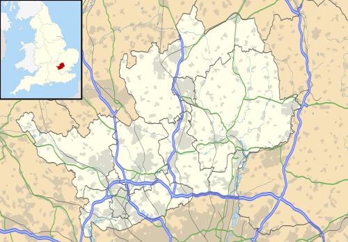
The 20 most populated settlements of the county of Hertfordshire, with district centres in yellow, and key towns and areas shown in white. . The county town is in bold.

This is a list of settlements in Hertfordshire ordered by population based on the results of the 2001 and 2011 censuses. In 2011 there were 35 settlements with 5,000 or more inhabitants in Hertfordshire. The next United Kingdom census will take place in 2021.

Contents

See the List of places in Hertfordshire article for an extensive list of local places and districts.


List of settlements

#SettlementDistrictPopulation (2001)Population (2011) [1]
1 Watford Watford 90,301131,982
2 Hemel Hempstead Dacorum 82,07494,932
3 Stevenage Stevenage 80,97389,663
4 St Albans St Albans 64,03882,146
5 Welwyn Garden City Welwyn Hatfield 43,25248,380
6 Cheshunt Broxbourne 38,72645,832
7 Hoddesdon Broxbourne 20,25042,253
8 Bishop's Stortford East Hertfordshire 34,92937,838
9 Hatfield Welwyn Hatfield 27,88337,577
10 Borehamwood Hertsmere 31,61635,489
11 Hitchin North Hertfordshire 30,76934,266
12 Letchworth North Hertfordshire 32,74633,249
13 Harpenden St Albans 27,95930,240
14 Hertford East Hertfordshire 24,18026,658
15 Bushey Hertsmere 14,48825,328
16 Rickmansworth Three Rivers 14,57123,973
17 Potters Bar Hertsmere 21,63922,639
18 Berkhamsted Dacorum 16,24320,641
19 Abbots Langley Three Rivers 10,47219,574
20 Ware East Hertfordshire 17,13318,799
21 Royston North Hertfordshire 14,36615,781
22 Broxbourne Broxbourne 13,29815,303
23 Chorleywood Three Rivers 6,81412,948
24 Croxley Green Three Rivers 11,52012,562
25 South Oxhey Three Rivers 11,983See notes
26 Tring Dacorum 11,63511,929
27 Baldock North Hertfordshire 9,86710,280
28 Waltham Cross Broxbourne 9,53910,069
29 Sawbridgeworth East Hertfordshire 7,6669,800
30 London Colney St Albans 7,5189,507
31 Radlett Hertsmere 8,1348,163
32 Oaklands Welwyn Hatfield 7,3997,711
33 How Wood St Albans 6,6746,834
34 Eastbury/Moor Park/Northwood Three Rivers 5,1885,253
35 Redbourn St Albans 4,6805,113
36 Bovingdon Dacorum 4,8804,997
37 Buntingford East Hertfordshire 4,8204,948
Notes

† - Watford count includes South Oxhey

See also

Related Research Articles

Hertfordshire County of England

Hertfordshire is one of the home counties in southern England. It borders Bedfordshire and Cambridgeshire to the north, Essex to the east, Greater London to the south, and Buckinghamshire to the west. For government statistical purposes, it forms part of the East of England region.

Watford Town and borough in Hertfordshire, England

Watford is a town and borough in Hertfordshire, England, 15 miles northwest of Central London, on the River Colne.

St Albans City and District Local authority district in England

The City and District of St Albans is a local authority district in Hertfordshire in the East of England region. The main urban settlements are St Albans and Harpenden. The council offices are in St Albans.

Hertsmere Place in England

Hertsmere is a local government district and borough in Hertfordshire, England. Its council is based in Borehamwood. Other settlements in the borough include Bushey, Elstree, Radlett and Potters Bar. The borough borders the three north London boroughs of Harrow, Barnet and Enfield, and is located mainly within the M25 Motorway.

Chorleywood is both a village and a civil parish in the Three Rivers District, Hertfordshire, on the border with Buckinghamshire, approximately 20 miles (32 km) northwest of Charing Cross. The village is adjacent to the Chiltern Hills Area of Outstanding Natural Beauty and is part of the London commuter belt included in the government-defined Greater London Urban Area. Chorleywood was historically part of the parish of Rickmansworth, becoming a separate ecclesiastical parish in 1845 and a separate civil parish in 1898. The population of the parish was 11,286 at the 2011 census.

Watford, Northamptonshire Human settlement in England

Watford is a village and civil parish in West Northamptonshire in England. At the time of the 2001 census, the parish's population was 224 people, including Murcott and increasing to 320 at the 2011 Census. Watford is home to Watford Gap services, the UK's oldest motorway service station, located directly on the M1 motorway and alongside the West Coast Main Line.

South West Hertfordshire (UK Parliament constituency) Parliamentary constituency in the United Kingdom, 1950 onwards

South West Hertfordshire is a constituency in the House of Commons of the UK Parliament, represented since 2019 by Gagan Mohindra, a Conservative.

Hertsmere (UK Parliament constituency) Parliamentary constituency in the United Kingdom, 1983 onwards

Hertsmere is a constituency in Hertfordshire, England, represented in the House of Commons since 2015 by Oliver Dowden, the current Co-chairman of the Conservative Party.

Watford (UK Parliament constituency) Parliamentary constituency in the United Kingdom, 1885 onwards

Watford is a constituency represented in the House of Commons of the UK Parliament since 2019 by Conservative Party MP Dean Russell.

Aldenham Human settlement in England

Aldenham is a village and civil parish in Hertfordshire, 3.5 miles (5.6 km) north-east of Watford and 2 miles (3.2 km) southwest of Radlett. It was mentioned in the Domesday Book and is one of Hertsmere's 14 conservation areas. The village has eight pre-19th-century listed buildings and the parish itself is largely unchanged, though buildings have been rebuilt, since Saxon times when the majority of the land was owned by the abbots of Westminster Abbey.

Watford Rural is a civil parish in the Three Rivers District of Hertfordshire, England. Located approximately 14 miles (23 km) northwest of central London and adjacent to the Greater London boundary, it is an urbanised parish characterised by suburban residential development. The local council is Watford Rural Parish Council. The parish covers South Oxhey and Carpenders Park, which although part of the Watford urban area, are outside the borough of Watford. The parish was created in 1894 when the ancient Watford parish was split into urban and rural parishes. At the 2011 census it had a population of 20,867.

Hertfordshire Fire and Rescue Service Fire and rescue service in southern England

Hertfordshire Fire and Rescue Service (HFRS) is the statutory fire and rescue service for the county of Hertfordshire, England. HFRS covers an area of 1,514 square miles (3,920 km2) and a population of 1.19 million.

Hertfordshire (European Parliament constituency) Constituency of the European Parliament

Hertfordshire was a constituency of the European Parliament located in the United Kingdom, electing one Member of the European Parliament by the first-past-the-post electoral system. Created in 1979 for the first elections to the European Parliament, it was abolished in 1999 on the adoption of proportional representation for European elections in the United Kingdom. It was succeeded by the East of England region.

Loudwater, Hertfordshire Human settlement in England

Loudwater is a private housing estate in the parish of Chorleywood, separated from the latter by the River Chess, north of Rickmansworth, Hertfordshire and just to the east of Junction 18 of the M25 motorway. Loudwater is an old name for the River Chess. The 2001 population was 1,242.

Great Munden

Great Munden is a village and civil parish in Hertfordshire, England. The parish, in the district of East Hertfordshire, spans 3,758 acres (5.872 sq mi), of which 1,895.75 acres (2.96211 sq mi) are arable land, 927.5 acres (1.4492 sq mi) are permanent grass and 97 acres (0.152 sq mi) are wood. It has a population of 477, reducing to 339 at the 2011 Census, and is situated 6 miles (9.7 km) north of the town of Ware. The village includes the church of St Nicholas, Munden Bury, and a rectory that includes the remains of a moat. Other settlements in the parish include Nasty and Levens Green. A detached portion of Little Munden was added to the parish in 1888.

References

  1. "Hertfordshire (County, East of England, United Kingdom) - Population Statistics and Location in Maps and Charts". www.citypopulation.de. Retrieved 30 November 2016.