List of settlements in Leicestershire by population

Last updated

Leicestershire UK location map.svg
Map showing the 10 largest settlements within Leicestershire.
Leicestershire UK location map.svg
Red pog.svg
BW
Red pog.svg
LFEKM
Red pog.svg
EN
Airplane silhouette.svg
EMA
Map showing the 11th to 15th largest settlements within Leicestershire.
Leicestershire UK location map.svg
Map showing the 16th to 20th largest settlements within Leicestershire.

Below is a list of settlements in Leicestershire (including the City of Leicester) by population

Contents

2021

In the 2021 UK census, the ONS places had a single definition, built-up area. [1]

#SettlementDistrictPopulation
I Leicester Leicester 406,580
II Loughborough Charnwood 64,860
III Hinckley Hinckley and Bosworth 50,725
IV Wigston Oadby and Wigston 34,730
V Melton Mowbray Melton 27,450
VI Market Harborough Harborough 24,165
VII Oadby Oadby and Wigston 24,030
IIX Coalville North West Leicestershire 21,980
IX Ashby-de-la-Zouch North West Leicestershire 15,120
X Shepshed Charnwood 14,870
XI Birstall Charnwood 14,315
XII Blaby & Whetstone Blaby 14,080
XIII Leicester Forest East
& Kirby Muxloe
Blaby 13,850
XIV Syston Charnwood 13,620
XV Enderby & Narborough Blaby 13,180
XVI Mountsorrel Charnwood 12,885
XVII Earl Shilton Hinckley and Bosworth 10,885
XVII Lutterworth Harborough 10,520
XIIX Broughton Astley Harborough 9,650
XIX Sileby Charnwood 8,955
XX Countesthorpe Blaby 7,670
XXI Castle Donington North West Leicestershire 7,345
XXII Kibworth Beauchamp
& Kibworth Harcourt
Harborough 7,330
XXII Anstey Charnwood 7,045
XXIII Barrow upon Soar Charnwood 6,820
XXIV Ibstock North West Leicestershire 6,810
XXV Groby Charnwood 6,560
XXV Quorndon Charnwood 5,575
XXVI Measham North West Leicestershire 5,370

2001 and 2011

Based on the results of the 2011 census, where the population exceeded 2,000 (52 settlements). In the 2001 census and 2011 census, the ONS places had wider (urban area in 2001 and built-up area in 2011) and lesser (built-up area subdivision in 2011) definitions.

RankBuilt-up areaPopulation [2] [3] [4] UA/borough/districtLocal areas included and excluded
20012011
1 Leicester *330,574

(279,921)

443,760 [5]

(329,839)

City of Leicester (UA)

Oadby and Wigston ;

Blaby, Charnwood, Harborough: parts

The makeup of the Leicester area figures is shown at the Leicester Built-Up Area article.

Figures in brackets are the population of the city council (Unitary Authority/UA) area.

2 Loughborough *55,25859,932 Charnwood Includes Dishley, Nanpantan, Snell's Nook, Shelthorpe, Thorpe Acre. Excludes Cotes, Hathern, Woodthorpe
3 Hinckley *43,24645,249 Hinckley and Bosworth Includes Burbage, Hollycroft, Middlefield, Sketchley. Excludes Aston Flamville, Wykin
4 Wigston *33,116⤴︎ Oadby and Wigston Included within Leicester's figure in 2011
5 Coalville *31,88434,024 North West Leicestershire Includes Agar Nook, Donington le Heath, Greenhill, Hugglescote, Thringstone, Whitwick. Excludes Abbots Oak, Bardon, Coleorton, Ellistown, Grace-Dieu, Griffydam, Newbold, Osgathorpe, Peggs Green, Ravenstone, Sinope, Snibston, Swannington
6 Melton Mowbray *25,55427,158 Melton Includes New Guadaloupe. Excludes Asfordby, Brentingby, Burton Lazars, Eye Kettleby, Old Guadaloupe, Thorpe Arnold, Welby
7 Market Harborough *20,12722,911 Harborough Includes Great Bowden, Little Bowden. Excludes East Farndon and Lubenham
8 Oadby 22,679⤴︎ Oadby and Wigston Included within Leicester's figure in 2011
9 Earl Shilton 18,36619,069 Hinckley and Bosworth Includes Barwell. Excludes Elmesthorpe
10 Narborough */
Enderby
12,99614,119 Blaby Excludes Croft, Littlethorpe, Huncote, Thurlaston
11 Shepshed 12,88213,505 Charnwood Includes Finney (Fenney) Hill and the Iveshead Road area. Excludes Blackbrook, Oaks in Charnwood
12 Syston 11,50812,804 Charnwood Excludes Barkby, East Goscote, Queniborough
13 Whetstone 6,10012,760(⇮) Blaby 2011 figure includes Blaby Village. Excludes Cosby
14 Ashby-de-la-Zouch 11,40912,370 North West Leicestershire Includes Cliftonthorpe and Rotherwood. Excludes Annswell, Blackfordby, Lount, Moira, Packington, Shellbrook, Smisby, Willesley
15 Birstall 11,48012,216 Charnwood Included within Leicester's figure in 2011
16 Mountsorrel 11,30612,120 Charnwood Includes Rothley. Excludes Cropston, Swithland
17 Lutterworth 8,7529,907 Harborough Includes Bitteswell. Excludes Cotesbach, Misterton
18 Broughton Astley 8,2908,940 Harborough Includes Primethorpe. Excludes Sutton in the Elms
19 Sileby 7,1038,433 Charnwood Includes Cossington. Excludes Seagrave
20 Groby 6,2566,782 Charnwood Excludes Glenfield, Ratby
21 Anstey 5,8216,528 Charnwood Excludes Newtown Linford
22 Castle Donington 5,9776,416 North West Leicestershire Includes Hill Top. Excludes Hemington, Lockington
23 Countesthorpe 6,3936,377 Blaby Excludes Kilby
24 Blaby Village6,163 Blaby See Whetstone for 2011
25 Ibstock 5,7606,201 North West Leicestershire Excludes Heather
26 Barrow-upon-Soar 5,0835,956 Charnwood
27 Kibworth Harcourt 4,7885,433 Harborough Includes Kibworth Beauchamp. Excludes Carlton Curlieu, Fleckney, Smeeton Westerby, Tur Langton
28 Measham 4,8495,209 North West Leicestershire Excludes Snarestone
29 Quorn 4,9615,177 Charnwood Excludes Woodhouse, Woodthorpe
30 Markfield 4,9694,993 Hinckley and Bosworth Includes Field Head, Little Markfield, Upper Grange. Excludes Stanton under Bardon
31 Fleckney 4,6104,894 Harborough Excludes Saddington, Wistow
32 Kirby Muxloe 4,5234,667 Blaby
33 Ratby 3,8624,468 Hinckley and Bosworth
34 Desford 3,6763,930 Hinckley and Bosworth Includes Botcheston and Newtown Unthank
35 Stoney Stanton 3,4543,793 Blaby
36 Moira/Norris Hill3,4963,763 North West Leicestershire Ashby Woulds parish count. Includes Albert Village, Boothorpe, Littleworth, Spring Cottage
37 Great Glen 3,2203,662 Harborough
38 Kegworth 3,3383,601 North West Leicestershire
39 Bottesford 3,4363,587 Melton
40 Cosby 3,6473,506 Blaby
41 Asfordby 3,1073,286 Melton Includes Ashfordby Hill, Ashfordby Valley, Welby
42 Newbold Verdon 3,1933,012 Hinckley and Bosworth Includes Brascote and Newbold Heath
43 East Goscote 2,8092,866 Charnwood
44 Donisthorpe 2,3362,637 North West Leicestershire Includes Oakthorpe
45 Ellistown 2,1062,626 North West Leicestershire Includes Battleflat
46 Bagworth 1,8362,605 Hinckley and Bosworth Includes Thornton
47 Harby 2,4282,577 Melton Includes Hose and Long Clawson
48 Sapcote 2,2572,442 Blaby
49 Queniborough 2,2572,326 Charnwood
50 Woodhouse 2,0132,319 Charnwood Includes Woodhouse Eaves
51 Ravenstone 2,1492,212 North West Leicestershire Includes parts of Sinope, Snibston
52 Market Bosworth 1,9062,097 Hinckley and Bosworth
53 Cropston 2,0762,074 Charnwood Includes Thurcaston

Notes:

See also

Related Research Articles

<span class="mw-page-title-main">East Midlands</span> Region of England

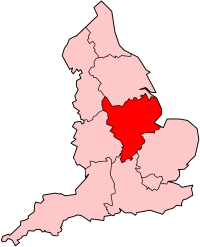
The East Midlands is one of nine official regions of England. It comprises the eastern half of the area traditionally known as the Midlands. It consists of Derbyshire, Leicestershire, Lincolnshire, Northamptonshire, Nottinghamshire, and Rutland. The region has an area of 15,627 km2 (6,034 sq mi), with a population over 4.5 million in 2011. With a sufficiency-level world city ranking, Nottingham is the only settlement in the region to be classified by the Globalization and World Cities Research Network.

<span class="mw-page-title-main">Leicestershire</span> County of England

Leicestershire is a ceremonial county in the East Midlands of England. It is bordered by Derbyshire, Nottinghamshire, and Lincolnshire to the north, Rutland to the east, Northamptonshire to the south-east, Warwickshire to the south-west, and Staffordshire to the west. The city of Leicester is the largest settlement and the county town.

<span class="mw-page-title-main">Northamptonshire</span> County of England

Northamptonshire is a ceremonial county in the East Midlands of England. It is bordered by Leicestershire, Rutland and Lincolnshire to the north, Cambridgeshire to the east, Bedfordshire, Buckinghamshire, Oxfordshire to the south and Warwickshire to the west. Northampton is the largest settlement and the county town.

<span class="mw-page-title-main">Midlands</span> Place in England

The Midlands is the central part of England, bordered by Wales, Northern England, Southern England and the North Sea. The Midlands correspond broadly to the early-medieval kingdom of Mercia, and later became important in the Industrial Revolution of the 18th and 19th centuries. They are now split into two official regions, the West Midlands and East Midlands. The Midlands' biggest city, Birmingham, is the second-largest in the United Kingdom. Other important cities include Coventry, Derby, Leicester, Lincoln, Nottingham, Stoke-on-Trent, Wolverhampton, and Worcester.

<span class="mw-page-title-main">Corby</span> Human settlement in England

Corby is a town and civil parish in the North Northamptonshire unitary authority area of Northamptonshire, England. It is located 23 miles (37 km) north-east of Northampton. From 1974 to 2021, the town served as the administrative headquarters of the Borough of Corby. At the 2021 Census, the built-up area had a population of 68,164 while the borough, which was abolished in 2021, had a population of 75,571 in 2021.

<span class="mw-page-title-main">Kettering</span> Town in England

Kettering is a market and industrial town in the North Northamptonshire unitary authority area of Northamptonshire, England. It forms a civil parish called Kettering Town. Kettering is located 67 miles (108 km) north of London and 15 miles (24 km) north-east of Northampton, west of the River Ise, a tributary of the River Nene. The name means "the place of Ketter's people ".

<span class="mw-page-title-main">Harborough District</span> Non-metropolitan district in England

Harborough is a local government district in Leicestershire, England. It is named after its main town, Market Harborough, which is where the council is based. The district also includes the town of Lutterworth and numerous villages and surrounding rural areas. In the north of the district it includes parts of the Leicester Urban Area, notably at Thurnby, Bushby and Scraptoft. Covering 230 square miles (600 km2), the district is the largest by area of the eight districts in Leicestershire and covers almost a quarter of the county.

The South Midlands is an area of England which includes Northamptonshire, the northern parts of Buckinghamshire and Oxfordshire and the western part of Bedfordshire. Unlike the East Midlands or West Midlands, the South Midlands is not one of the NUTS statistical regions of the United Kingdom.

<span class="mw-page-title-main">Bosworth (UK Parliament constituency)</span> UK Parliament constituency in England since 1885

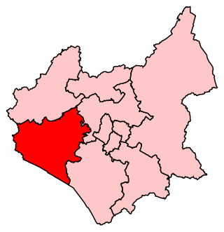
Bosworth is a constituency represented in the House of Commons of the UK Parliament since 2019 by Luke Evans, a Conservative.

<span class="mw-page-title-main">Kettering railway station</span> Railway station in Northamptonshire, England

Kettering railway station serves the town of Kettering in Northamptonshire, England. It lies south-west of the town centre, on the Midland Main Line, 71 miles (115 km) north of London St. Pancras.

<span class="mw-page-title-main">Leicestershire Police</span> English territorial police force

Leicestershire Police is the territorial police force responsible for policing the counties of Leicestershire and Rutland in England. Its headquarters are at Enderby, Leicestershire.

<span class="mw-page-title-main">Great Easton, Leicestershire</span> Human settlement in England

Great Easton is a village and civil parish in the Harborough district of Leicestershire, England. The parish had a population of 558 according to the 2001 census, increasing to 671 at the 2011 census.

The Leicester Urban Area or Leicester Built Up Area is an urban agglomeration defined by the Office of National Statistics (ONS), centred on the City of Leicester in the East Midlands, England. With a population of 559,017 at the time of the 2021 census, increased from 508,916 at the time of the 2011 census, the Built Up Area is the eleventh largest in England and thirteenth largest in the United Kingdom. It comprises Leicester itself and its suburbs, all of which are contiguous with or situated in close proximity to the city.

The LE postcode area, also known as the Leicester postcode area, is a group of 21 postcode districts in central England, within 12 post towns. These cover most of Leicestershire and most of Rutland, plus small parts of south Nottinghamshire and north Northamptonshire, and very small parts of Derbyshire and Warwickshire.

<span class="mw-page-title-main">Scouting in the East Midlands</span>

Scouting activities can be found throughout the English region of the East Midlands. The largest number of Scouts and volunteer leaders in the region is linked to the Scout Association of the United Kingdom, while there is also a presence of traditional Scouting groups, such as the Baden-Powell Scouts' Association. The Scout Association administers the region through five Scout Counties, overseen by a regional commissioner, which largely follow the boundaries of the ceremonial counties they exist within although in Lincolnshire the former Humberside county is still used. There are also a number of Scouting clubs within Universities in the region which are affiliated to the Student Scout and Guide Organisation. Scouting organisations at every level of the hierarchy also own and operate campsites and activity centres in the area for the benefit of Scouts, Guides and other youth groups.

<span class="mw-page-title-main">Rutland</span> County in England

Rutland, sometimes archaically called Rutlandshire, is a ceremonial county in the East Midlands of England. It borders Leicestershire to the north and west, Lincolnshire to the north-east, and Northamptonshire to the south-west. Oakham is the largest town.

<span class="mw-page-title-main">Borough of Corby</span> Non-metropolitan district and borough in England

Corby was a non-metropolitan district with borough status in the county of Northamptonshire, England. It bordered the East Northamptonshire district to the east, the Borough of Kettering to the south and west, the Harborough district of Leicestershire to the north-west, and the county of Rutland to the north-east. In 2021 the district had a population of 75,571. The council, Corby Borough Council was based at the Cube in the town of Corby.

References

  1. Ref for table. "Figure 1: Explore population characteristics of individual BUAs" . Retrieved 4 April 2024.
  2. "Leicestershire (County, East Midlands, United Kingdom) – Population Statistics and Location in Maps and Charts". www.citypopulation.de. Retrieved 29 November 2016.
  3. "Leicester (Unitary District, East Midlands, United Kingdom) – Population Statistics and Location in Maps and Charts". www.citypopulation.de. Retrieved 29 November 2016.
  4. "Leicester (Unitary District, East Midlands, United Kingdom) – Population Statistics and Location in Maps and Charts". www.citypopulation.de. Retrieved 20 April 2017.
  5. UK Census (2011). "Local Area Report – Leicester BUA (E35001399)". Nomis. Office for National Statistics . Retrieved 16 July 2019.