
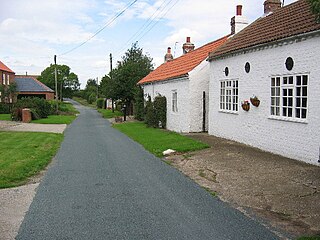
Breedon on the Hill is a village and civil parish about 5 miles (8 km) north of Ashby-de-la-Zouch in North West Leicestershire, England. The parish adjoins the Derbyshire county boundary and the village is only about 2 miles (3 km) south of the Derbyshire town of Melbourne. The 2001 Census recorded a parish population of 958 people in 404 households. The parish includes the hamlets of Tonge 1 mile (1.6 km) east of the village and Wilson 1.3 miles (2 km) north of the village on the county boundary. The population at the 2011 census was 1,029 in 450 households.

Castle Donington is a market town and civil parish in Leicestershire, England, on the edge of the National Forest and close to East Midlands Airport.

Shardlow is a village in Derbyshire, England about 6 miles (9.7 km) southeast of Derby and 11 miles (18 km) southwest of Nottingham. Part of the civil parish of Shardlow and Great Wilne, and the district of South Derbyshire, it is also very close to the border with Leicestershire, defined by the route of the River Trent which passes close to the south. Just across the Trent is the Castle Donington parish of North West Leicestershire.
Aike is a hamlet and former civil parish, now in the parish of Lockington, in the East Riding of Yorkshire, England. The hamlet is centred around a single developed street, which lies to the east of the Yorkshire Wolds. Aike is approximately 4 miles (6 km) north of Beverley and approximately 0.4 miles (1 km) from the west bank of the River Hull. It is approached by a 2.5-mile (4 km) lane which is a no-through road that does not continue beyond the village, although a farm track continues as far as a bridge across the Beverley and Barmston Drain. In 1931 the parish had a population of 48.

Tilton on the Hill is a village and a former civil parish, now in the parish of Tilton on the Hill and Halstead in the Harborough district of Leicestershire. The population of the civil parish of Tilton on the Hill and Halstead at the 2011 census was 601. It lies 2 miles north of the A47, on the B6047 to Melton Mowbray. Halstead civil parish was merged with Tilton on 1 April 1935, while the deserted medieval village of Whatborough was merged in on 1 April 1994. Marefield remains a separate civil parish, but is part of the Tilton Electoral Ward. In 1931 the parish of Tilton had a population of 152. St Peter's Tilton, the Parish Church is in the parish of Halstead, as is the vicarage.

Waltham on the Wolds is a village and former civil parish, now in the parish of Waltham on the Wolds and Thorpe Arnold, in the Melton borough of Leicestershire, England. It lies about 5 miles (8.0 km) north-east of Melton Mowbray and 11 miles (17.7 km) south-west of Grantham on the main A607 road. In 1931 the parish had a population of 510. The population of Waltham on the Wolds and Thorpe Arnold was 967 in 2011.

Bardon is a civil parish and former village in North West Leicestershire about 1.5 miles (2.4 km) southeast of the centre of Coalville. The parish includes Bardon Hill, which at 912 feet (278 m) above sea level is the highest point in Leicestershire. With the population remaining less than 100, information from the 2011 census was included in the civil parish of Ellistown and Battleflat.

Hartshill is a large village and civil parish in North Warwickshire, England, adjoined with the much larger town of Nuneaton, the town centre of which is 2.5 miles (4 km) to the south-east. The parish borders the district of Nuneaton and Bedworth at the south, the North Warwickshire district parishes of Ansley at the south-west, Mancetter at the north-west, and Caldecote at the east, and the parish of Witherley in Leicestershire to the north-east from which it is separated by the A5 road. The market town of Atherstone is 3.5 miles (6 km) to the north-west.

Draycott and Church Wilne is a civil parish within the Borough of Erewash, which is in the county of Derbyshire, England. Partially built up and otherwise rural, its population was 3,090 residents in the 2011 census. The parish is 100 miles (160 km) north west of London, 5+1⁄2 miles (8.9 km) south east of the county city of Derby, and 3 miles (4.8 km) west of the nearest market town of Long Eaton. It shares a boundary with the parishes of Breaston, Elvaston, Hopwell, Ockbrook and Borrowash, Risley and Shardlow and Great Wilne.

Sawley is a village and civil parish in the Harrogate district of North Yorkshire, England. It is about 4 miles (6.4 km) west of Ripon. From this position, the Yorkshire Dales are to the west and the North Yorkshire Moors and coast are to the east. The village is located within the Nidderdale area of outstanding natural beauty.

Sawley is a village and civil parish within the Borough of Erewash, in southeast Derbyshire, England. With a slightly higher than average number of people over 65, the population of just the civil parish was measured at 6,629 as at the 2011 Census.

Sewstern is a village and former civil parish, now in the parish of Buckminster, in the Melton district of east Leicestershire, England. It lies just south of Buckminster, with which it shares a primary school, situated between the two villages. It is 9 miles east of Melton Mowbray, 10 miles south of Grantham and 4 miles from the A1 at Colsterworth. It is the easternmost village in Leicestershire.
Cavendish Bridge is a bridge over the River Trent, connecting the counties of Leicestershire and Derbyshire; it is also the name of a hamlet on the Leicestershire side of the river within the Castle Donington parish. This bridge once carried the main London-Manchester turnpike, though the modern A6/A50 dual carriageway has now been built to the south bypassing the crossing.

Lockington-Hemington is a civil parish in the North West Leicestershire district of Leicestershire, England. The parish includes the villages of Hemington and Lockington. According to the 2001 census it had a population of 556, rising to 838 at the 2011 census.

Harston is a crossroads village and former civil parish, now in the parish of Belvoir, in the Melton district, in Leicestershire, England, near the border with Lincolnshire. The nearest town is Grantham, about 6 miles (10 km) to the north-east. It once contained several quarries for iron ore. Part of the village borders Lincolnshire. In 1931 the parish had a population of 182. On 1 April 1936 the parish was abolished and merged with Belvoir.
Lockington is a village and former civil parish, now in the parish of Lockington-Hemington, in the North West Leicestershire district of Leicestershire, England. The village is close to the Derbyshire border.

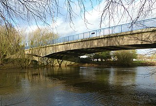
Harrington Bridge crosses the River Trent near Sawley in Derbyshire carrying the Tamworth Road (B6540) into Leicestershire. The stonework of the bridge dates from 1790, but the central section was replaced in 1905 after it was damaged by flood water. The central section is the only part of the bridge that is not a listed building.

Branston is a village and former civil parish, now in the parish of Croxton Kerrial in the Melton district, in the county of Leicestershire, England. It lies 1 mile (1.6 km) north of the A607 road, 7 miles (11 km) south-west of Grantham and 7 miles north-east of Melton Mowbray, on the southern edge of the Vale of Belvoir, 3 miles (5 km) south-west of Belvoir Castle. Knipton Reservoir is 700 yards (640 m) to the north. In 1931 the parish had a population of 249.

High and Low Bishopside is a civil parish in Nidderdale, in North Yorkshire, England. It includes the town of Pateley Bridge and the villages of Glasshouses and Wilsill, the southern part of Wath and the hamlets of Blazefield, and Fellbeck.

Prior to 1866, Wilsthorpe was originally a hamlet and civil parish situated between the villages of Breaston 0.97 miles (1.56 km) to the west and Long Eaton 0.94 miles (1.51 km) to the east in Derbyshire and lies approximately 7.75 miles (12.47 km) east of the city of Derby. According to the University of Nottingham English Place-names project, the settlement name Wilsthorpe could mean 'Willow-tree wood clearing'; salh (Anglian) A willow-tree or a sallow, pers.n. pers.n. Personal name, hlāw A tumulus or a hill, and thorp for a small village. The site where the hamlet once stood, along with 76% of the former parish area, is now a suburb of Long Eaton.


