
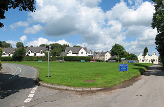
Griffydam is a hamlet within the parish of Worthington, Leicestershire . [1]
Griffydam is a hamlet within the parish of Worthington, Leicestershire . [1]
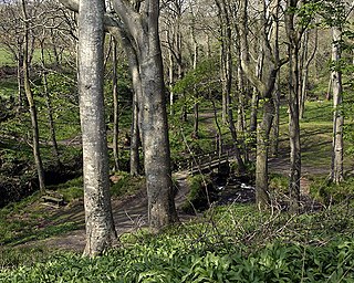
Griffydam is most famously associated with a chalybeate well, or sacred spring, which lies along a path below the main road through the village. According to tradition, the name Griffydam derives from a combination of the terms Griffin (an ancient mythical beast with the body of a lion and the head and wings of an eagle) and Dam, a contained water source. An old local legend tells of how such a creature zealously guarded the well, forcing villagers to walk several miles for their water, until one day it was slain by a chivalrous passing knight.[ citation needed ]
The placename actually derives from 'Griffith's-Dam'. A man-made pond and remnants of the bank built for this dam can still be seen, below the lane called 'The Tentas'. [2] Several nineteenth century trade directories refer to the settlement as 'Griffth's-Dam'. [3]
The name 'Griffydam' occurs as early as 1764, when it is referred to as being noted for its mineral water, as a place near Ashby-de-la-Zouch. [4] It is also referred to as Griffy-dam in Edmund Gibson's revised (1722) edition of William Camden's "Britannia". [5]
In 1863, it was described as comprising approximately 200 acres (0.81 km2) and belonged to the Earl of Stamford and J Curzon, Esq. [6]
The place is also well known for once having had a popular nightclub called The Traveller's Rest, known to locals as "Travs". Originally a public house, this was converted into a nightspot late in the twentieth century and was finally closed in about 2000, much to the relief of local residents. [7]
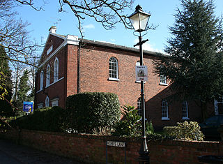
Griffydam has one of the country's earliest Methodist Chapels, built in 1778. It is claimed that before the chapel was built John Wesley came to preach in the village when he was staying with his friend, Selina, Countess of Huntingdon at Castle Donington. It is said that Beaumont, the local squire of Coleorton, decided to disrupt the event by gathering together a band of local men, priming them with ale and arming them with truncheons. The gang-leader was John Massey, a local collier, renowned pugilist and terror of North Leicestershire.[ dubious ] Massey is said to have approached the slightly built preacher "savagely", but Wesley continued his sermon. Massey decided to hear a little of what was being said before giving the signal to attack, but the attack never came, for he was converted on the spot. [8]
A Wesleyan Reform Church, opened in 1858, lies alongside the Rempstone Road and is known as 'The Chapel in the Valley'.

Breedon on the Hill is a village and civil parish about 5 miles (8 km) north of Ashby-de-la-Zouch in North West Leicestershire, England. The parish adjoins the Derbyshire county boundary and the village is only about 2 miles (3 km) south of the Derbyshire town of Melbourne. The 2001 Census recorded a parish population of 958 people in 404 households. The parish includes the hamlets of Tonge 1 mile (1.6 km) east of the village and Wilson 1.3 miles (2 km) north of the village on the county boundary. The population at the 2011 census was 1,029 in 450 households.

Measham is a large village in the North West Leicestershire district in Leicestershire, England, near the Derbyshire, Staffordshire and Warwickshire boundaries. It lies off the A42, 4+1⁄2 miles (7.2 km) south of Ashby de la Zouch, in the National Forest. Historically it was in an exclave of Derbyshire absorbed into Leicestershire in 1897. The name is thought to mean "homestead on the River Mease". The village was once part of Derbyshire before being transferred to Leicestershire.

Whitwick is a village and civil parish in the North West Leicestershire district of Leicestershire, England, close to the town of Coalville in the northwest of the county. It lies in an ancient parish which formerly included the equally historic villages of Thringstone and Swannington.
Wolsingham is a market town in Weardale, County Durham, England. It is situated by the River Wear, between Crook and Stanhope.

Tilton on the Hill is a village and a former civil parish, now in the parish of Tilton on the Hill and Halstead in the Harborough district of Leicestershire. The population of the civil parish of Tilton on the Hill and Halstead at the 2011 census was 601. It lies 2 miles north of the A47, on the B6047 to Melton Mowbray. Halstead civil parish was merged with Tilton on 1 April 1935, while the deserted medieval village of Whatborough was merged in on 1 April 1994. Marefield remains a separate civil parish, but is part of the Tilton Electoral Ward. In 1931 the parish of Tilton had a population of 152. St Peter's Tilton, the Parish Church is in the parish of Halstead, as is the vicarage.

Bartestree is a village and civil parish in Herefordshire, England, 7 km (4.3 mi) east of Hereford on the A438 road. The population of the civil parish at the 2011 census was 330.

Worthington is a village and civil parish in North West Leicestershire, England, about 4 miles (6.4 km) north of the town of Coalville and a similar distance north-east of the market town of Ashby-de-la-Zouch. The population of the civil parish at the 2011 census was 1,461. The village is about 5 miles (8 km) from East Midlands Airport and junction 23a of the M1 motorway where it meets the A42 road. The parish also includes the hamlet of Newbold.

Gaddesby is a village and civil parish in the Melton borough of Leicestershire, England. The population of the civil parish at the 2011 census was 762. It is located around 5.5 miles (8.9 km) southwest of Melton Mowbray and 8 miles (13 km) northeast of Leicester.

Thringstone is a village in the North West Leicestershire district, in Leicestershire, England. About 3 miles (4.8 km) north of Coalville, it lies in the English National Forest.

Overseal is a village and civil parish in South Derbyshire district of Derbyshire, England. It is 3 miles (4.8 km) south of Swadlincote, 5 miles (8.0 km) west of Ashby-de-la-Zouch and 13 miles (21 km) south-southwest of Derby. It had a population of the civil parish at the 2011 census was 2,450. Situated within the National Forest area, it is near the villages of Netherseal and Lullington as well as being close to the border with Leicestershire. It is one of the southernmost settlements in Derbyshire.
Colby is a small village in the south of the Isle of Man in the parish of Arbory. It lies on the A7 road between the towns of Castletown and Port Erin and close to the similarly sized village of Ballabeg.
Devauden is a village and community in Monmouthshire, southeast Wales. It is located between Chepstow and Monmouth near the top of the Trellech ridge on the B4293 road. The community covers an area of 3,790 hectares (14.6 sq mi), and includes the villages of Itton and Wolvesnewton, Llanfihangel-tor-y-mynydd and Newchurch.

William Railton (1800–77) was an English architect, best known as the designer of Nelson's Column. He was based in London, with offices at 12 Regent Street for much of his career.
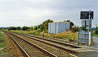
Asfordby railway station was a station serving the villages of Asfordby and Kirby Bellars in Leicestershire. The station was situated at a level crossing on the road between the two villages. It opened in 1846 and was originally named Kirby, but had been renamed Asfordby by 1863. It closed to passengers in 1951 but remained in use for goods until 1964.
Gelsmoor is a hamlet within the parish of Worthington in the English county of Leicestershire.

Newbold otherwise Newbold Coleorton is a large hamlet in the parish of Worthington, Leicestershire, England. It is situated in the North West Leicestershire district, approximately midway between the town of Ashby-de-la-Zouch and the village of Whitwick, just to the north of the B5324 route.
The Congregational Chapel, also known as the Independent Chapel, is a former Congregational or Independent church in Nantwich, Cheshire, England. It is located on Monks Lane, now a pedestrian walkway, opposite the Dysart Buildings and immediately north east of St Mary's Church. Built in 1841–42, it is listed at grade II. The chapel closed in the late 20th century, and the building has been converted to residential use.

Chapel-en-le-Frith is a town and civil parish in the Borough of High Peak in Derbyshire, England.

The Mythe Chapel is located at Tewkesbury on the Mythe. The Mythe Chapel was the only place of worship on the Mythe after the Dissolution. The chapel was built in 1870 with funds from the Marquis de Lys who had lived in Tewkesbury since 1863. An old group of stables originally occupied the site and were partly incorporated into the new building to which windows, niches and buttresses were added.

Storrs is a hamlet within the boundaries of the City of Sheffield in England, it is situated 4 miles (6.4 km) west-northwest of the city centre. Storrs is located between the suburb of Stannington and the village of Dungworth in the civil parish of Bradfield at a height of 210 metres above sea level between the Loxley and Rivelin valleys. Although historically a farming settlement, water-powered milling on the Storrs Brook and small scale cutlery making has also taken place in the hamlet.
Towns and villages of North West Leicestershire | ||
|---|---|---|
| Towns |  | |
| Large villages | ||
| Small villages |
| |
| Hamlets | ||