Related Research Articles

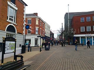
Ashby-de-la-Zouch, sometimes spelt Ashby de la Zouch and shortened locally to Ashby, is a market town and civil parish in the North West Leicestershire district of Leicestershire, England. The town is near to the Derbyshire and Staffordshire borders. Its 2001 census population of 11,410 rose to 12,370 in 2011. The castle in the town was an important fort in the 15th–17th centuries. In the 19th century the town's main industries were ribbon manufacture, coal mining, and brickmaking.

The Ashby-de-la-Zouch Canal is a 31-mile (50 km) long canal in England which connected the mining district around Moira, just outside the town of Ashby-de-la-Zouch in Leicestershire, with the Coventry Canal at Bedworth in Warwickshire. It was opened in 1804, and a number of tramways were constructed at its northern end, to service collieries. The canal was taken over by the Midland Railway in 1846, but remained profitable until the 1890s, after which it steadily declined. Around 9 miles (14 km) passed through the Leicestershire coal field, and was heavily affected by subsidence, with the result that this section from Moira, southwards to Snarestone, was progressively closed in 1944, 1957 and 1966, leaving 22 miles (35 km) of navigable canal.

Donisthorpe is a village in the North West Leicestershire district of Leicestershire, England, historically an exclave of Derbyshire.

North West Leicestershire is a local government district in Leicestershire, England. The population of the Local Authority at the 2011 census was 93,348. Its main towns are Ashby-de-la-Zouch, Castle Donington, Coalville and Ibstock.
Hinckley and Bosworth is a local government district with borough status in south-western Leicestershire, England, administered by Hinckley and Bosworth Borough Council. Its only towns are Hinckley, Earl Shilton and Market Bosworth. Villages include Barwell, Burbage, Stoke Golding, Groby, Shackerstone and Twycross. The population of the Borough at the 2011 census was 105,078.

Kegworth is a large village and civil parish in the North West Leicestershire district of Leicestershire, in the East Midlands region, England. It forms part of the border with Nottinghamshire and is situated 6 miles north of Loughborough, 12 miles southwest of Nottingham, 12.5 miles southeast of Derby and 17 miles north of Leicester. The population of Kegworth as of the 2011 census was 3,601.

Earl Ferrers is a title in the Peerage of Great Britain. It was created in 1711 for Robert Shirley, 14th Baron Ferrers of Chartley. The Shirley family descends from George Shirley of Astwell Castle, Northamptonshire. In 1611 he was created a Baronet, of Staunton Harold in the County of Leicester, in the Baronetage of England. He was succeeded by his son Henry, the second Baronet, who married Lady Dorothy Devereux, daughter of Robert Devereux, 2nd Earl of Essex. On the death of her brother Robert Devereux, 3rd Earl of Essex, she became the youngest co-heir to the baronies of Ferrers of Chartley and the barony of Bourchier, which had fallen into abeyance on the death of the third Earl. Shirley was succeeded by his eldest son, the third Baronet. He died unmarried and was succeeded by his younger brother, the fourth Baronet. He was imprisoned in the Tower of London by Cromwell and died there in 1656. On his death the title passed to his eldest son, the fifth Baronet. He died at an early age and was succeeded at birth by his posthumous son, the sixth Baronet.

Laurence Shirley, 4th Earl Ferrers was an English nobleman, notable for being the last peer to be hanged, following his conviction for murdering his steward.

Measham is a large village in the North West Leicestershire district in Leicestershire, England, near the Derbyshire, Staffordshire and Warwickshire boundaries. It lies off the A42, 4½ miles south of Ashby de la Zouch, in the National Forest. Historically it was in an exclave of Derbyshire absorbed into Leicestershire in 1897. The name is thought to mean "homestead on the River Mease".
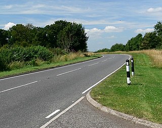
The A512 is an A road entirely in Leicestershire, UK. It links the primary destination of Loughborough with the M1, A42 road, and the town of Ashby de la Zouch.

Worthington is a village and civil parish in North West Leicestershire, England, about 4 miles (6.4 km) north of the town of Coalville and a similar distance north-east of the market town of Ashby-de-la-Zouch. The population of the civil parish at the 2011 census was 1,461. The village is about 5 miles (8 km) from East Midlands Airport and junction 23a of the M1 motorway where it meets the A42 road. The parish also includes the hamlet of Newbold.
Busta Voe, (HU665350), in the north central Mainland, Shetland, is a sea inlet lying between the village of Brae and the island of Muckle Roe. At the head of the voe is the Delting Marina and Boating Club.
Vice Admiral Washington Shirley, 5th Earl Ferrers, FRS was a British Royal Navy officer, peer, freemason and amateur astronomer.

Coleorton is a village and civil parish in North West Leicestershire, England. It is situated on the A512 road approximately 2 miles (3.2 km) east of Ashby de la Zouch. Nearby villages include Newbold, to the north, Thringstone to the east, and Swannington to the south-east.
Staunton Harold is a civil parish in North West Leicestershire about 3 miles (5 km) north of Ashby-de-la-Zouch. The parish is on the county boundary with Derbyshire and about 9 miles (14 km) south of Derby. The 2011 Census recorded the parish's population as 141.

Newbold otherwise Newbold Coleorton is a large hamlet in the parish of Worthington, Leicestershire, England. It is situated in the North West Leicestershire district, approximately midway between the town of Ashby-de-la-Zouch and the village of Whitwick, just to the north of the B5324 route.

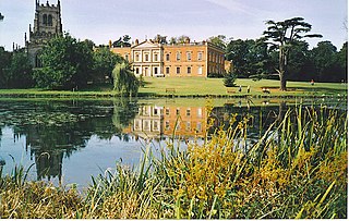
Staunton Harold Hall is a large 18th-century Grade I listed country house built by the Earls Ferrers, situated within the 2,000-acre (810 ha) Staunton Harold Park in Staunton Harold, Leicestershire, England, which includes the 17th-century Grade I listed Holy Trinity Chapel.

New Lount is a 21.3 hectares Local Nature Reserve north-east of Ashby-de-la-Zouch in Leicestershire. It is owned and managed by Leicestershire County Council.
The Ashby-de-la-Zouch Museum is a museum in the Leicestershire town of Ashby-de-la-Zouch. The primary aim of the museum is to educate the public about the history of the town. The museum also has a number of temporary exhibitions. The museum opened its doors in 1982, with the museum relocating to its present location on North Street in Ashby-de-la-Zouch. The museum is run by a group of approximately 70 volunteers.
References
Towns and villages of North West Leicestershire | ||
|---|---|---|
| Towns |  | |
| Large villages | ||
| Small villages |
| |
| Hamlets | ||
Coordinates: 52°46′13.43″N1°25′42.10″W / 52.7703972°N 1.4283611°W
| | This Leicestershire location article is a stub. You can help Wikipedia by expanding it. |