
North West Leicestershire is a local government district in Leicestershire, England. The towns in the district include of Ashby-de-la-Zouch, Castle Donington, Coalville and Ibstock. Notable villages in the district include Donington le Heath, Ellistown, Hugglescote, Kegworth, Measham, Shackerstone, Thringstone and Whitwick.

Normanton is a town in the civil parish of Normanton and Altofts, in the City of Wakefield in West Yorkshire, England. It is north-east of Wakefield and south-west of Castleford. The civil parish extends west and north to the River Calder, and includes the large village of Altofts. At the time of the 2011 Census, the population of the civil parish was 20,872.
Waldridge is a village in County Durham, in England. The population at the 2001 Census was 215. Prior to the 2011 Census the parish boundaries changed and the population shown at this census was 4,215. It is situated to the south west of Chester-le-Street. It is known as either Waldridge Fell or Waldridge Village, the 'Fell' referring to the surrounding area of moorland. The village used to be known as Waldridge Colliery. The current village dates back to the 1890s, the original village having been located on the fell which overlooks the present location. Rainwater runs into the Cong Burn to the north and the South Burn to the south, both of which flow into the River Wear which is a few miles to the east.

Frampton Cotterell is a village and civil parish in South Gloucestershire, England, on the River Frome. The village is contiguous with Winterbourne to the south-west and Coalpit Heath to the east. The parish borders Iron Acton to the north and Westerleigh to the south-east, the large town of Yate is 2 miles away. The village is 8 miles north-east of Bristol. The population of the village together with the adjoining village of Winterbourne was 14,694 in 2011. The population of the parish alone was 6,520 at the 2011 census.

Newbold Verdon is a village and civil parish in the county of Leicestershire, England. The parish includes Newbold Heath to the north and Brascote to the south. Originally an agricultural centre Newbold Verdon grew in size during the 1850s with the expansion of coal mining in the area. That industry has now ceased leaving Newbold Verdon as a commuter village primarily serving Leicester and Hinckley. The 2001 census recorded a population of 3,193, which had reduced to 3,012 at the 2011 census.

Heather is a village west of Ibstock in North West Leicestershire, England. The population of the civil parish was 949 at the 2001 census reducing to 920 at the 2011 census. In the Domesday Book of 1086, its name is recorded as Hadre, meaning "the heathland".
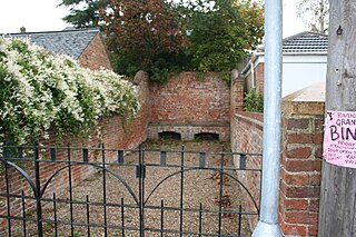
Ravenstone is a village and former civil parish, now in the parish of Ravenstone with Snibstone, in the North West Leicestershire district, in the county of Leicestershire, England. It is within the National Forest, just off the A511 road between Coalville and Ashby-de-la-Zouch, in 2001 it had a population of 2,149.

Temple Normanton is a village and a civil parish in the North East Derbyshire district in Derbyshire, England. The population of the civil parish at the 2011 census was 490.

Chailey is a village and civil parish in the Lewes District of East Sussex, England. It is located 7 miles north of Lewes, on the A272 road from Winchester to Canterbury. The Prime Meridian passes just to the east of Chailey.
Wivelsfield village and the larger adjacent village of Wivelsfield Green are the core of the civil parish of Wivelsfield in the Lewes District of East Sussex, England. The villages are 9.3 miles (15.0 km) north of the city of Brighton and Hove.

Pyecombe is a village and civil parish in the Mid Sussex District of West Sussex, England. Pyecombe is located 7 miles (11 km) to the north of Brighton. The civil parish covers an area of 887 hectares and has a population of 200, increasing at the 2011 Census to a population of 237.

Packington is a village and civil parish in the district of North West Leicestershire. It is situated close to the A42 road and the towns of Ashby de la Zouch and Measham. The population of Packington according to the 2001 UK census is 738, reducing slightly to 734 at the 2011 census. Nearby villages include Normanton le Heath and Heather.

Little Budworth is a civil parish and village between Winsford and Chester, in the unitary authority of Cheshire West and Chester and the ceremonial county of Cheshire, England. The population of the civil parish taken at the 2011 census was 594. It is primarily known as the location of the Oulton Park motor racing circuit.

Snibston is an area and former civil parish east of Ravenstone, now in the parish of Ravenstone with Snibstone, in the North West Leicestershire district, in the county of Leicestershire, England. Originally rural, part of Snibston was transformed into a coal mining village by the opening of coal mines by the Snibston Colliery Company in the early 1830s. This industrial part of Snibston was subsequently subsumed into the developing town of Coalville, though small rural areas of Snibston survive within the civil parishes of Ravenstone with Snibston and Hugglescote and Donington le Heath. In the part of Snibston within the latter civil parish stands the 13th-century church of St Mary, noted as the smallest church still in use for regular worship in England. The main Snibston Colliery was sunk in 1831, and after its closure the Snibston Country Park with the Snibston Discovery Museum was built on part of the colliery site. Part of the park is Snibston Grange Local Nature Reserve.

Swinley Forest is a large expanse of Crown Estate woodland managed by Forestry England mainly within the civil parishes of Windlesham in Surrey and Winkfield and Crowthorne in Berkshire, England.

The River Sence is a river which flows in Leicestershire, England. The tributaries of the Sence, including the Saint and Tweed, fan out over much of western Leicestershire from Charnwood Forest and Coalville in the north-east to Hinckley and almost to Watling Street in the south and south-west. Its watershed almost coincides with Hinckley and Bosworth Borough of Leicestershire, which was formed in 1974 by amalgamation of Market Bosworth Rural District and Hinckley Urban District. It flows into the Anker, which in turn flows into the River Tame. It is part of the wider River Trent catchment, which covers much of central England. In 1881, Sebastian Evans wrote that the usual names for this river were Shenton Brook and Sibson Brook.

Icklingham is a village and civil parish in the West Suffolk district of Suffolk in eastern England. It is located about 7 miles (11 km) north-west of Bury St Edmunds, 4 miles (6.4 km) south-east of Mildenhall and 9 miles (14 km) south-west of Thetford in Norfolk. The village is on the A1101 road between Bury St Edmunds and Mildenhall in the north-west of the county. The area around the village, characterised by a sandy gravel-laden soil, is known as Breckland, though an arm of the fen-like peat follows the River Lark past the village.

Henfield is a hamlet in the civil parish of Westerleigh and Coalpit Heath, in the South Gloucestershire district, in the ceremonial county of Gloucestershire, England. It is between Coalpit Heath and Westerleigh, adjoining the hamlet of Ram Hill immediately to the north.

Ram Hill is a hamlet in the civil parish of Westerleigh and Coalpit Heath, in the South Gloucestershire district, in the ceremonial county of Gloucestershire, England. It is located between Coalpit Heath and Westerleigh and adjoins the hamlet of Henfield immediately to the south. In the Mudge Map 1815, Ram Hill was known as Nutridge Hill, and was linked to Westerleigh by Broad Lane and to Mays Hill by Frog Lane.

The Queen Elizabeth Diamond Jubilee Wood is a woodland in Leicestershire, UK created in 2012. Covering 186 hectares, it is the centrepiece of a wide-ranging Jubilee Project by the Woodland Trust to mark the 2012 Diamond Jubilee of Queen Elizabeth II. The site incorporates a former opencast coal mine which now has a newly created lake, as well as former arable land and 7 hectares of existing ancient woodland and old hedgerows. Situated between the villages of Normanton le Heath, Heather and Ravenstone, and close to Coalville and Ashby de la Zouch, it is in the middle of the National Forest.


