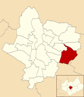
Evington is an area of Leicester, and electoral ward of the Leicester district, in the ceremonial county of Leicestershire, England. It used to be a small village centred on Main Street and the Anglican church of St Denys but was close enough to Leicester to become one of the outer suburbs in the 1930s. Today, the ward comprises the historical village of Evington, as well as the modern ex-council estates of Rowlatts Hill and Goodwood. The population of the ward at the 2011 census was 11,133.

Carlton is a small rural parish located east of the River Sence in Leicestershire, England, around 2.2 miles north of Market Bosworth. According to the 2011 census, Carlton has a population of 305 However, from 2014 it is estimated that there are around 330 people living there with a total of 283 registered electors. There are four roads in Carlton:

Harborough is a local government district in Leicestershire, England. It is named after its main town, Market Harborough, which is where the council is based. The district also includes the town of Lutterworth and numerous villages and surrounding rural areas. In the north of the district it includes parts of the Leicester Urban Area, notably at Thurnby, Bushby and Scraptoft. Covering 230 square miles (600 km2), the district is the largest by area of the eight districts in Leicestershire and covers almost a quarter of the county.

Ibstock is a former coal mining town and civil parish in North West Leicestershire, England. The population of the civil parish was 5,760 at the 2001 census increasing to 6,201 at the 2011 census and 7,615 at the 2021 census.

Broughton Astley is a large village and civil parish located in the Harborough district of Leicestershire, England. It is situated in the south of Leicestershire, about 6 miles (10 km) east of Hinckley, about 9 miles (14 km) from the centre of Leicester, and about 14 miles from Coventry. The parish borders the Blaby district to the north, as well as sharing borders with the parishes of Cosby, Leire, and Dunton Bassett. The population of the civil parish at the time of the 2011 census was 8,940. A tributary of the River Soar runs through it.
Blaston is a village and civil parish in the Harborough district of Leicestershire. It is a small parish with a population of 54 according to the 2001 census. As the population had remained less than 100, details from the 2011 census are included in the civil parish of Horninghold. The village is near Nevill Holt, Medbourne and Hallaton. St Giles' Church in Blaston was rebuilt in 1878. Blaston was first mentioned in the Domesday Book and the name probably means the settlement of Bleath.

Great Easton is a village and civil parish in the Harborough district of Leicestershire, England. The parish had a population of 558 according to the 2001 census, increasing to 671 at the 2011 census.

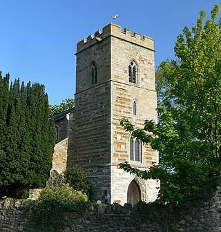
Garthorpe is a village and civil parish in Leicestershire, England, in the Melton district. It is about five miles east of Melton Mowbray. The parish includes the villages of Garthorpe and Coston, and is near Saxby, Wymondham, Buckminster and Sproxton.

Burton Overy is a village and civil parish in the Harborough district of Leicestershire, about nine miles south-east of Leicester city centre, and not far from Great Glen. According to the 2001 census, the parish had a population of 289., increasing at the 2011 census to 440.
Cranoe is a small village and civil parish in the Harborough district of Leicestershire, England. The parish had a population of 35 in 2001. The population remained less than 100 and was included in the civil parish of Glooston.
Hallaton is a village and civil parish in the Harborough district of Leicestershire, England. According to the 2001 census the parish had a population of 523, which had increased to 594 at the 2011 census.

Thorpe in the Glebe was a village in Nottinghamshire to the south of Wysall on the Leicestershire border. It was sometimes called Thorpe in the Clottes. Tradition has it that the village was destroyed either at the Battle of Willoughby Field or alternatively by a hail-storm. However, at the time of the English Civil War, there had been no village at Thorpe in the Glebe for nearly 200 years.

King's Norton is a village and civil parish in the Harborough district of Leicestershire, England. It is situated to the east of Leicester, and about 2+1⁄2 miles (4 km) south-west from Billesdon. According to the 2001 census the parish had a population of 69. At the 2011 census the population remained less than 100 and is included in the civil parish of Gaulby.

Stockerston is a village and civil parish in the Harborough district of Leicestershire, England, located on the border with Rutland, by the Eye Brook. According to the 2001 census the parish had a population of 35. The population remained less than 100 at the 2011 census and is included in the civil parish of Horninghold.

Diseworth is a village and former civil parish, now in the parish of Long Whatton and Diseworth, in the North West Leicestershire district, in the English county of Leicestershire. It is south of East Midlands Airport and off Junction 23A of the M1 motorway.

Swinford is a nucleated village and civil parish in the Harborough district of the English county of Leicestershire. The population of the civil parish at the 2011 census was 586. It used to be on the former A427, which led under the M1, to Catthorpe. The parish church is All Saints, a 12th-century Norman rebuilding of an earlier Saxon church with a 14th-century square bell tower and a Grade II* listed building. The local pub is The Chequers on the High Street, formerly known as Chequer Inn.

East Carlton is a village and civil parish in the county of Northamptonshire, on the southern ridge overlooking the Welland valley to the north and covers 1,645 acres (666 ha) on a long strip of land. It is 2 miles (3.2 km) west of the town of Corby and is administered as part of North Northamptonshire but was previously in the Corby borough until 2021. At the time of the 2001 census, the parish's population was 270, reducing to 259 at the 2011 census. East Carlton is one of the Thankful Villages that suffered no fatalities during World War I.

Noseley is a village and civil parish in the Harborough district of Leicestershire, England.
Saddington is a village in the Harborough district of Leicestershire, England. It is close to Smeeton Westerby, Gumley, Kibworth and Fleckney. The population of the civil parish at the 2011 census was 309.

Eastwell is a village and ecclesiastical parish in Leicestershire, England.


