List of windmills in Leicestershire

Last updated

Leicestershire UK location map.svg
Red pog.svg
1
Red pog.svg
2
Red pog.svg
3
Blue pog.svg
4
Red pog.svg
5
Red pog.svg
6
Red pog.svg
7
Red pog.svg
8
Red pog.svg
9
Red pog.svg
10
Red pog.svg
11
Red pog.svg
12

A list of windmills in Leicestershire.

Mills in bold are still standing, known building dates are indicated in bold. Text in italics denotes indicates that the information is not confirmed, but is likely to be the case stated.

Contents

Locations

A - C

LocationName of mill and
grid reference
TypeMapsFirst mention
or built
Last mention
or demise
Photograph
Arnesby Arnesby Mill
SP 614 925
tower 1815 [1] Windmill World Arnesby windmill.jpg
Ashby Folville Ashby Mill
Gaddesby Mill

SK 697 124
Tower Early 19th century [2] Windmill World Mill Farm, Ashby Road, Gaddesby - geograph.org.uk - 144439.jpg
Barkestone-le-Vale Barkestone Mill
SK 779 349
Tower Windmill World
Belgrave 1545 [3] 1558 [3]
Billesdon 1558 [4] 1826 [4]
Blaston 1302 [5] 1675 [5]
Bringhurst 1629 [6] 1650 [6]
BringhurstGone by 1964 [6]
Burrough on the Hill 1607 [7] 1614 [7]
Burton Overy 1646 [8] 1766, gone by 1835 [8]
Burton Overy1766 [8] 1766, gone by 1835 [8]
Carlton Curlieu 1592 [9] 1661 [9]
Church Langton 1792 [10] 1792 [10]
Cranoe 1440 [11] 1441 [11]
Croxton Kerrial Croxton Mill
SK 8372 2907
Smock 1806 [12] Windmill World Croxton Kerrial.jpg

E - G

LocationName of mill and
grid reference
TypeMapsFirst mention
or built
Last mention
or demise
Photograph
Evington 1308 [13] 1335 [13]
Fleckney 1338 [14] 1338 [14]
Foxton Late 12th century [15] 1317 [15]
Foxton1780 [15] 1885 [15]
Galby 16th century [16] 16th century [16]
Gilmorton Gilmorton Mill
SP 577 883
Tower Early 19th century [17] Windmill World Gilmorton mill.jpg
Glooston 15th century [18] 1637 [18]
Great Bowden 1473 [19] 1690 [19]
Great Glen 1352 [20] 1563 [20]

H - K

LocationName of mill and
grid reference
TypeMapsFirst mention
or built
Last mention
or demise
Photograph
Hallaton Bardolf's Manor1290 [21] 1588 [21]
HallatonHacluit's Manor1373 [21] 1652 [21]
Harby Harby Mill
SK 738 312
Tower Truncated during the Second World War [22] Windmill World Disused Windmill - geograph.org.uk - 54983.jpg
Higham on the Hill Windmill World
Houghton on the Hill 1301 [23] 1301 [23]
Houghton on the HillNew Ingarsby [23]
Houghton on the HillIngarsby Lane1914, gone by 1918 [23]
Husbands Bosworth 1252 [24] 1252 [24]
Illston on the Hill c. 1220 [25] 1588 [25]
Kegworth Post [26]
Kibworth Beauchamp 1315 [27] 1687 [27]
Kibworth Harcourt Kibworth Harcourt Mill
SP 689 944
Post 1711 [27] Windmill World Kibworth Harcourt mill.jpg
King's Norton 1514 [28] 1582 [28]
Knighton Narborough Wood Farm Titt iron wind engine 1896

L

LocationName of mill and
grid reference
TypeMapsFirst mention
or built
Last mention
or demise
Photograph
Laughton 1265 [29] 1658 [29]
Leicester Castle Mills1632 [30]
LeicesterNewarke Mills1626 [30] 1741 [30]
LeicesterNorth Mills1821 [30] 1833 [30]
LeicesterSouth Fields Mill
Nurse's Mill
1316 [30] 1638 [31]
LeicesterSouth Fields Mill
Nurses Mill
Standing until mid-19th century [30]
LeicesterBetween Castle and Newarke Mills Post 17791720 [30] 1779
LeicesterSt Margaret's1779
1828
1585 [30] 1828
LeicesterSt Margaret's
(2nd mill) [30]
177917791779
LeicesterSt Margaret's
(3rd mill) [30]
177917791779
LeicesterLondon Road [30] 177917791835 [30]
LeicesterLondon Road
(2nd mill) [30]
177917791835 [30]
Leicester Narborough Road [30]
LeicesterMount Pleasant Mill [30] 18281828
LeicesterConduit St [30] tower 1826
1828
18261828
LeicesterMarston's Mill, Saxby St [30] 1826
1828
18261828
LeicesterWhetstone's Mill, Highfield St [30] 1826
1828
18261828
LeicesterHolmes' Mill, Mill La [30] 1826
1828
18261846 [30]
LeicesterFreak's Ground182818281861, gone by 1891 [32]
Little Stretton 1314 [28] 1446 [28]
Long Clawson Long Clawson Mill
SK728 267
Tower Early 19th century [33] Windmill World Long Clawson Windmill.JPG
Lubenham 1624 [34] 1659 [34]

M - R

LocationName of mill and
grid reference
TypeMapsFirst mention
or built
Last mention
or demise
Photograph
Market Harborough Great Bowden Mill Smock 1839 [35] Standing c. 1920
Medbourne Mid-16th century [36] Mid-16th century [36]
Medbourne Smock Late 18th century [36] Demolished January 1902 [36]
Mowsley 1338 [37] 1338 [37]
Narborough Titt iron wind engine
Nether Broughton SK 691 258 Post 1880s OS map
Noseley 1545 [38] 1545 [38]
Redmile 1242 [39] 1242 [39]
RedmileRedmile Mill Midlands Post 1835 [39] 1920s [39]

S - W

LocationName of mill and
grid reference
TypeMapsFirst mention
or built
Last mention
or demise
Photograph
Shangton c. 1304 [40] c. 1304 [40]
Shepshed Fenney Spring Mill
SK 462 181
Tower c. 1840 [41] Windmill World Fenny Spring Mill, Shepshed.jpg
Slawston 1637 [42] 1928 [42]
Smeeton Westerby Blown down c. 1885 [27]
Stonton Wyville Early 17th century [43] Early 17th century [43]
Stoughton 1341 [44] 1477 [44]
Swannington Hough Mill
SK 410 171
Tower Late 18th century [45] Windmill World Hough Mill, Swannington.jpg
Swannington Post Blown down early 19th century [45]
Swannington Post Early 19th century [45] Demolished 1895 [45]
Syston Syston Mill
SK 621 109
Post Windmill World
Thringstone Thringstone Windmill tower
Thurnby BushbyEarly 17th century [44] Early 17th century [44]
Tur Langton Smith's Mill
Moore's Mill
17th century [10] Gone by 1850 [10]
Tur LangtonHalford's Mill17th century [10] Gone by 1850 [10]
Ullesthorpe Ullesthorpe Mill
SP 506 877
Tower 1800 [46] Windmill World Ullesthorpe Mill.jpg
Waltham on the Wolds Waltham Mill
SK 803 248
Post Demolished 1868 [47]
Waltham on the WoldsWaltham Mill
SK 803 248
Tower 1868 [47] Windmill World
Wistow 1436 [48] 1660 [48]
Woodhouse Eaves Woodhouse Eaves Mill
SK 526 143
Midlands Post 1863 [49] Burnt down 1945 [49]
Windmill World
Wymondham Wymondham Mill
SK 850 192
Tower c. 1813 [50] Windmill World Wymondham Mill, Leics.jpg

Locations formerly in Leicestershire

Maps

Related Research Articles

Leicestershire County of England

Leicestershire is a landlocked county in the English Midlands, being within the East Midlands. The county borders Nottinghamshire to the north, Lincolnshire to the north-east, Rutland to the east, Northamptonshire to the south-east, Warwickshire to the south-west, Staffordshire to the west, and Derbyshire to the north-west. The border with most of Warwickshire is Watling Street, the modern A5 road.

Melton Mowbray Town in Leicestershire, England

Melton Mowbray is a town in Leicestershire, England, 19 miles (31 km) north-east of Leicester, and 20 miles (32 km) south-east of Nottingham. It lies on the River Eye, known below Melton as the Wreake. The town population of 27,158 in the 2011 census was estimated at 27,670 in 2019. Its culinary speciality is the Melton Mowbray pork pie. It is also the location of one of six licensed makers of Stilton cheese. It is sometimes promoted as Britain's "Rural Capital of Food".

Harborough District District in England

Harborough is a local government district of Leicestershire, England, named after its main town, Market Harborough. Covering 230 square miles (600 km2), the district is by far the largest of the eight district authorities in Leicestershire and covers almost a quarter of the county.

Borough of Melton Borough in England

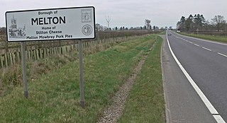
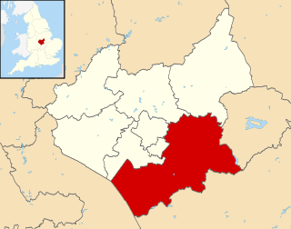
Melton is a local government district with borough status in north-eastern Leicestershire, England. It is named after its main town, Melton Mowbray. Other settlements include Asfordby and Bottesford. At the 2011 census, it had a population of 50,376.

Blaby (UK Parliament constituency) Parliamentary constituency in the United Kingdom, 1974–2010

Blaby was a county constituency represented in the House of Commons of the Parliament of the United Kingdom, which existed from 1974 until 2010. It elected one Member of Parliament (MP) by the first past the post system of election. It was a safe seat for the Conservative Party, being held by Conservative MPs throughout its existence.

Long Clawson Village in Leicestershire, England

Long Clawson is a village and former civil parish, now included in that of Clawson, Hose and Harby, in the Melton district and the county of Leicestershire, England. Being in the Vale of Belvoir, the village is enclosed by farmland with rich soil ideal for pasture. Milk from local farms is used for Stilton cheese, of which the Long Clawson dairy is one of the largest producers. In 1931 the civil parish had a population of 664.

Ullesthorpe Human settlement in England

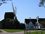
Ullesthorpe is a small village and civil parish situated in the Harborough district in southern Leicestershire. Ullesthorpe is noted for its historic background with a mill, disused railway station and traces of a medieval settlement evident on the edge of the village.

Wymondham, Leicestershire Village in Leicestershire, England

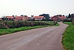
Wymondham is a village in the Borough of Melton in Leicestershire, England. It is part of a civil parish which also covers the nearby hamlet of Edmondthorpe. The parish has a population of 623, increasing to 632 at the 2011 census. It is close to the county boundaries with Lincolnshire and Rutland, nearby places being Garthorpe, Teigh and South Witham.

Redmile Human settlement in England

Redmile is an English village and civil parish in the Melton district of Leicestershire, about ten miles (16 km) north of Melton Mowbray and seven miles (11 km) west of Grantham. The population of the civil parish, which includes Barkestone-le-Vale and Plungar), was 921 at the 2011 census, up from 829 in 2001.

Gaddesby Human settlement in England

Gaddesby is a village and civil parish in the Melton borough of Leicestershire, England. The population of the civil parish at the 2011 census was 762. It is located around 5.5 miles (8.9 km) southwest of Melton Mowbray and 8 miles (13 km) northeast of Leicester.

Branston, Leicestershire Village in Leicestershire, England

Branston is a village in the civil parish of Croxton Kerrial and Branston, Leicestershire, England. It lies 1 mile (1.6 km) north of the A607 road, 7 miles (11 km) south-west of Grantham and 7 miles north-east of Melton Mowbray, on the southern edge of the Vale of Belvoir, 3 miles (5 km) south-west of Belvoir Castle. Knipton Reservoir is 700 yards (640 m) to the north. The population is included in the civil parish of Croxton Kerrial.

Plungar Village in Leicestershire, England

Plungar is a village in the civil parish of Redmile, and the Melton district of Leicestershire, England. It is about 9 miles (14 km) north of the market town of Melton Mowbray and 7 miles (11 km) west from Grantham. Plungar is adjacent to the Grantham Canal and stands in the Vale of Belvoir.

References

  1. Historic England. "WINDMILL, LUTTERWORTH ROAD (north side), ARNESBY, HARBOROUGH, LEICESTERSHIRE (1061540)". National Heritage List for England . Retrieved 2008-12-03.
  2. Historic England. "GADDESBY WINDMILL, ASHBY ROAD (north side), GADDESBY, MELTON, LEICESTERSHIRE (1061265)". National Heritage List for England . Retrieved 2008-12-03.
  3. 1 2 "BELGRAVE". British History Online. Retrieved 2008-12-03.
  4. 1 2 "BILLESDON". British History Online. Retrieved 2008-12-03.
  5. 1 2 "BLASTON". British History Online. Retrieved 2008-12-03.
  6. 1 2 3 "BRINGHURST". British History Online. Retrieved 2008-12-03.
  7. 1 2 "BURROUGH ON THE HILL". British History Online. Retrieved 2008-12-03.
  8. 1 2 3 4 "BURTON OVERY". British History Online. Retrieved 2008-12-03.
  9. 1 2 "CARLTON CURLIEU". British History Online. Retrieved 2008-12-03.
  10. 1 2 3 4 5 6 "CHURCH LANGTON". British History Online. Retrieved 2008-12-03.
  11. 1 2 "CRANOE". British History Online. Retrieved 2008-12-03.
  12. Historic England. "WINDMILL AT NATIONAL GRID REFERENCE (8372 2907), MAIN STREET, CROXTON KERRIAL, MELTON, LEICESTERSHIRE (1360863)". National Heritage List for England . Retrieved 2008-12-03.
  13. 1 2 "EVINGTON". British History Online. Retrieved 2008-12-03.
  14. 1 2 "FLECKNEY". British History Online. Retrieved 2008-12-03.
  15. 1 2 3 4 "FOXTON". British History Online. Retrieved 2008-12-03.
  16. 1 2 "GALBY AND FRISBY". British History Online. Retrieved 2008-12-03.
  17. Historic England. "GILMORTON MILL, MILL LANE (east side), GILMORTON, HARBOROUGH, LEICESTERSHIRE (1209161)". National Heritage List for England . Retrieved 2008-12-03.
  18. 1 2 "GLOOSTON". British History Online. Retrieved 2008-12-03.
  19. 1 2 "GREAT BOWDEN". British History Online. Retrieved 2008-12-03.
  20. 1 2 "GREAT GLEN". British History Online. Retrieved 2008-12-03.
  21. 1 2 3 4 "HALLATON". British History Online. Retrieved 2008-12-03.
  22. "A Portrait of Harby, Leicestershire". Stuart Frew. Retrieved 2008-12-03.
  23. 1 2 3 4 "HOUGHTON ON THE HILL". British History Online. Retrieved 2008-12-03.
  24. 1 2 "HUSBAND'S BOSWORTH". British History Online. Retrieved 2008-12-03.
  25. 1 2 "ILLSTON ON THE HILL". British History Online. Retrieved 2008-12-03.
  26. Wailes, Rex (1954). The English Windmill. London: Routledge & Kegan Paul. p. 172.
  27. 1 2 3 4 "KIBWORTH". British History Online. Retrieved 2008-12-03.
  28. 1 2 3 4 "KING'S NORTON". British History Online. Retrieved 2008-12-03.
  29. 1 2 "LAUGHTON". British History Online. Retrieved 2008-12-03.
  30. 1 2 3 4 5 6 7 8 9 10 11 12 13 14 15 16 17 18 19 20 21 22 "MILLS". British History Online. Retrieved 2008-12-03.
  31. "POLITICAL AND ADMINISTRATIVE HISTORY 1509-1651". British History Online. Retrieved 2008-12-03.
  32. "NORTH-WEST LEICESTER". British History Online. Retrieved 2008-12-03.
  33. Historic England. "WIND MILL AT MILL FARM, MILL LANE (east side), CLAWSON, HOSE AND HARBY, MELTON, LEICESTERSHIRE (1188244)". National Heritage List for England . Retrieved 2008-12-03.
  34. 1 2 "LUBENHAM". British History Online. Retrieved 2008-12-03.
  35. "MARKET HARBOROUGH". British History Online. Retrieved 2008-12-03.
  36. 1 2 3 4 "MEDBOURNE". British History Online. Retrieved 2008-12-03.
  37. 1 2 "MOWSLEY". British History Online. Retrieved 2008-12-03.
  38. 1 2 "NOSELEY". British History Online. Retrieved 2008-12-03.
  39. 1 2 3 4 "Redmile Archive". Redmile Archive. Retrieved 2008-12-03.
  40. 1 2 "SHANGTON". British History Online. Retrieved 2008-12-03.
  41. "FENNY SPRING WINDMILL". English Heritage. Archived from the original on 2012-12-24. Retrieved 2008-12-03.
  42. 1 2 "SLAWSTON". British History Online. Retrieved 2008-12-03.
  43. 1 2 "STONTON WYVILLE". British History Online. Retrieved 2008-12-03.
  44. 1 2 3 4 "THURNBY". British History Online. Retrieved 2008-12-03.
  45. 1 2 3 4 "Hough Mill Restoration". Swannington Heritage. Archived from the original on 2008-05-09. Retrieved 2008-12-03.
  46. Historic England. "ULLESTHORPE MILL, MILL ROAD (west side), ULLESTHORPE, HARBOROUGH, LEICESTERSHIRE (1292776)". National Heritage List for England . Retrieved 2008-12-03.
  47. 1 2 "The Old Mill, Waltham, Leicestershire". English Heritage. Retrieved 2008-12-03.
  48. 1 2 "WISTOW". British History Online. Retrieved 2008-12-03.
  49. 1 2 "Woodhouse Eaves Windmill". Midland Mills Open. Archived from the original on September 5, 2008. Retrieved 2008-12-03.
  50. Historic England. "WYMONDHAM WINDMILL, BUTT LANE (west side), WYMONDHAM, MELTON, LEICESTERSHIRE (1307233)". National Heritage List for England . Retrieved 2008-12-03.