Nuneaton is a market town in Warwickshire, England, close to the county border with Leicestershire to the north-east. Nuneaton's population at the 2021 census was 88,813, making it the largest town in Warwickshire. Nuneaton's urban area, which also includes the large villages of Bulkington and Hartshill, had a population of 99,372 at the 2021 census.

Donisthorpe is a village in the North West Leicestershire district of Leicestershire, England, historically an exclave of Derbyshire.
Hinckley and Bosworth is a local government district with borough status in Leicestershire, England. The council is based in Hinckley, the largest town. The borough also includes the town of Earl Shilton and numerous villages and surrounding rural areas. The Bosworth in the borough's name refers to the small market town of Market Bosworth, near which the Battle of Bosworth Field was fought in 1485.

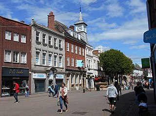
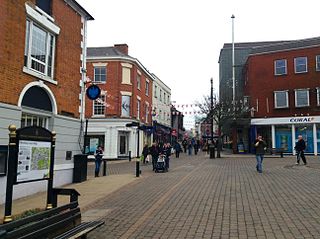
Hinckley is a market town in south-west Leicestershire, England. It is administered by Hinckley and Bosworth Borough Council. Hinckley is the third largest settlement in Leicestershire, after Leicester and Loughborough. Hinckley is about halfway between Leicester and Coventry and borders Nuneaton in Warwickshire. Watling Street forms part of the Leicestershire/Warwickshire border. The town forms an urban area with the village of Burbage, directly to the south.
Leicester Forest East (LFE) is a large suburban village in Leicestershire, England, west of Leicester, straddling the M1 motorway. It is part of the Blaby district.

Market Bosworth is a market town and civil parish in Leicestershire, England. At the 2001 Census, it had a population of 1,906, increasing to 2,097 at the 2011 census. It is most famously near to the site of the decisive final battle of the Wars of the Roses.

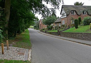
Carlton is a small rural parish located East of the river Sence in Leicestershire, England, around 2.2 miles North of Market Bosworth. According to the 2011 Census, Carlton has a population of 305 However, from 2014 it is estimated that there are around 330 people living there with a total of 283 registered electors. There are four roads in Carlton:

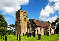
Sutton Cheney is a village and former civil parish, now in the parish of Dadlington and Sutton Cheney, in the borough of Hinckley and Bosworth, in the county of Leicestershire, England, near the county border with Warwickshire. In addition to the village of Sutton Cheney itself, the civil parish also contains the villages of Dadlington and Shenton, a number of farms, and the location of the Battle of Bosworth. Its closest large towns are Nuneaton and Hinckley. Its closest market town is Market Bosworth.

Narborough is a large village and civil parish in the Blaby district of Leicestershire, England, around six miles southwest of Leicester. The population of the civil parish at the 2011 census was 8,498.

Fenny Drayton is a village and former civil parish, now in the parish of Witherley, in the Hinckley and Bosworth district of Leicestershire, England. It lies near the Warwickshire boundary, three miles south-east of Atherstone in the Coventry postcode area, just off the A444, the Roman Watling Street. Another Roman road crosses at the end of the scenic Fenn Lanes. The village is four miles from Stoke Golding, where Henry VII of England was crowned after the Battle of Bosworth in 1485. The reinterment of Richard III of England on 21 March 2015 started along Fenn Lanes, near the village. In 1931 the parish had a population of 125. On 1 April 1935 the parish was abolished and merged with Witherley, parts also went to Hartshill, Mancetter and Caldecote. The name means "farm/settlement for portage" or "farm/settlement used as a dragging place". "Fenny" reflects the fen-like ground along the Roman road.

Barlestone is a village and civil parish in the Hinckley and Bosworth district of Leicestershire, England, adjoining the village of Osbaston. The UK Census reported Barlestone's population as 2,471 in 2001, and 2,481 in 2011.

Elmesthorpe is a village and civil parish in the Blaby district of Leicestershire, England. It is situated to the south-east of Earl Shilton, near to Hinckley on the A47 road. In 2004, the parish had an estimated population of 520, reducing to 509 at the 2011 census.
Snarestone is a small rural village in North West Leicestershire, England.
Ellistown is a village about 2 miles (3 km) south of Coalville in North West Leicestershire, England. It is named after Colonel Joseph Joel Ellis who died in 1885. The population from the 2011 census was included in the civil parish of Ellistown and Battleflat.
Shenton is a village and former civil parish, now in the parish of Dadlington and Sutton Cheney, in the Hinckley and Bosworth district, in the county of Leicestershire, England, situated 2.20 miles (3.54 km) south-west of Market Bosworth. Shenton was formerly a chapelry and township of the parish of Market Bosworth. The settlement is almost entirely agricultural, containing several farms. Much of the land has been in the same family since William Wollaston purchased the manor in 1625. It is essentially a privately owned estate village and has seen comparatively little modern development. It has been designated a conservation area. The settlement lies either side of the Sence Brook, which is crossed by a picturesque Victorian bridge. The area is fairly flat, and subject to flooding. In 1931 the parish had a population of 154.
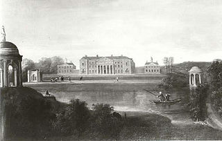
Gopsall is a former civil parish, now in the parish of Twycross, in the Hinckley and Bosworth district, in the county of Leicestershire, England. It is located between the villages of Appleby Magna, Shackerstone, Twycross and Snarestone. In 1931 the parish had a population of 13. Gopsall was formerly an extra-parochial tract, from 1858 Gopsall was a civil parish in its own right, on 1 April 1935 the parish was abolished and merged with Twycross.

The River Sence is a river which flows in Leicestershire, England. The tributaries of the Sence, including the Saint and Tweed, fan out over much of western Leicestershire from Charnwood Forest and Coalville in the north-east to Hinckley and almost to Watling Street in the south and south-west. Its watershed almost coincides with Hinckley and Bosworth Borough of Leicestershire, which was formed in 1974 by amalgamation of Market Bosworth Rural District and Hinckley Urban District. It flows into the Anker, which in turn flows into the River Tame. It is part of the wider River Trent catchment, which covers much of central England. In 1881, Sebastian Evans wrote that the usual names for this river were Shenton Brook and Sibson Brook.

Congerstone is a village and former civil parish, now in the parish of Shackerstone, in the Hinckley and Bosworth district, in Leicestershire, England. It is three miles north west of Market Bosworth, of which it was historically a daughter parish. It is near the Ashby-de-la-Zouch Canal and the A444 road. In 1931 the parish had a population of 209.

Hugglescote is a village on the River Sence in North West Leicestershire, England. The village is about 1 mile (1.6 km) south of the centre of Coalville, and its built-up area is now contiguous with the town.
Lindley Hall Farm is a farm in Leicestershire, England, in close proximity to Fenny Drayton and Higham on the Hill. The farm is owned by Stephen Farmer. It has been best known as the geographical centre of England since the Ordnance Survey's investigation in 2002. A plaque has been erected by the Ordnance Survey denoting the geographical central point and disputing the historically believed idea that Meriden was the geographical centre.