
The River Parrett flows through the counties of Dorset and Somerset in South West England, from its source in the Thorney Mills springs in the hills around Chedington in Dorset. Flowing northwest through Somerset and the Somerset Levels to its mouth at Burnham-on-Sea, into the Bridgwater Bay nature reserve on the Bristol Channel, the Parrett and its tributaries drain an area of 660 square miles (1,700 km2) – about 50 per cent of Somerset's land area, with a population of 300,000.
The River Ant is a tributary river of the River Bure in the county of Norfolk, England. It is 27 kilometres (17 mi) long, and has an overall drop of 27 metres from source to mouth. It is said that the Ant was formerly known as the River Smale and that this is the origin of the name of the village of Smallburgh.

The River Thurne is a river in Norfolk, England in The Broads. Just 7 miles (11 km) long, it rises 2 miles (3.2 km) from the coast near Martham Broad and is navigable from West Somerton. It flows southwest and is linked by Candle Dyke and Heigham Sound to both Horsey Mere and Hickling Broad. It continues southwest and flows through Potter Heigham and enters the River Bure just south of Thurne dyke, near St Benet's Abbey.

The River Wissey is a river in Norfolk, eastern England. It rises near Bradenham, and flows for nearly 31 miles (50 km) to join the River Great Ouse at Fordham. The lower 11.2 miles (18.0 km) are navigable. The upper reaches are notable for a number of buildings of historic interest, which are close to the banks. The river passes through the parkland of the Arts and Crafts Pickenham Hall, and further downstream, flows through the Army's Stanford Training Area (STANTA), which was created in 1942 by evacuating six villages. The water provided power for at least two mills, at Hilborough and Northwold. At Whittington, the river becomes navigable, and is surrounded by fenland. A number of pumping stations pump water from drainage ditches into the higher river channel.
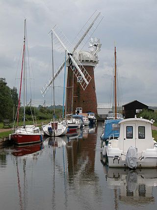
Horsey Windpump is a windpump or drainage windmill in the care of the National Trust in the village of Horsey, on The Broads near Great Yarmouth, Norfolk, England. The structure is a grade II* listed building.

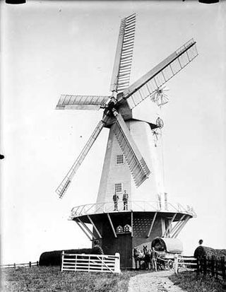
Durrington or High Salvington Windmill is a Grade II listed post mill in High Salvington, Sussex that has been restored and is in full working order. The mill stands 320 feet (98 m) above sea level and is able to take advantage of incoming sea winds.

Bourne Eau is a short river which rises from an artesian spring in the town of Bourne in Lincolnshire, England, and flows in an easterly direction to join the River Glen at Tongue End. Within the town, it once powered three water mills, one of which is now a heritage centre. At Eastgate, it becomes much wider as it was navigable in the 18th and 19th centuries, and this was the location of the terminal basin. Below the town it is an embanked river, as its normal level is higher than that of the surrounding Fens. Navigation ceased in the 1860s and the river now forms an important part of the drainage system that enables the surrounding fen land to be used for agriculture.

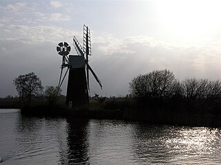
Brograve Mill is a windpump located on Brograve level in the parish of Sea Palling within the Norfolk Broads National Park, United Kingdom. It can be found at grid reference TG448235 and is approximately 1 mile north of Horsey Mere. The mill is a Grade II listed building.
Sir Berney Brograve, 1st Baronet was the eldest son and heir of Thomas Brograve (1691–1753) of Great Baddow, Essex, and his wife Juliana Berney. He was a descendant of Sir John Brograve, Attorney-General to the Duchy of Lancaster. Juliana Berney was descended from Sir Richard Berney, 1st Baronet of Parkhall.

Lambrigg Fell is a hill, the highest point of the area of high ground between Kendal and the M6, in south-eastern Cumbria, England.

Waxham is a village and former civil parish, now in the parish of Sea Palling, in the North Norfolk district, in the county of Norfolk, England. It lies on the north-east coast of the county. Buildings in the village include Waxham Hall, the 14th-century St. John's Church and the 16th-century Waxham Great Barn. Waxham Hall is reputedly haunted by the ghosts of six members of the Brograve family, all of whom died in battle. It is said that an 18th-century owner of the house once invited them all to dinner. Waxham Great Barn built about 1570, at 178 feet long is one of the largest barns of its age in the country. It has recently been restored and opened to the public. The village has an extensive beach backed by dunes. Many migrant birds pass through the area in spring and autumn and common cranes feed in fields near the village. In 1931 the parish had a population of 84.
Sea Palling is a village and civil parish covering 11.05 km2 (4.27 sq mi) in the English county of Norfolk. The village is 19.6 miles (31.5 km) south-east of Cromer, 19.6 miles (31.5 km) north-east of Norwich and 140 miles (230 km) north-east of London. The village lies 4 mi (6.4 km) east of the A149 between Kings Lynn and Great Yarmouth. The nearest railway station is at North Walsham for the Bittern Line, which runs between Sheringham, Cromer, and Norwich.
Ringle Crouch Green Mill is a smock mill in Sandhurst, Kent, England, that was demolished to base level in 1945, and now has a new smock tower built on it as residential accommodation and an electricity generator.

Stubb Drainage Windmill is 1.9 miles east of Hickling in the English county of Norfolk. The Windmill is a Grade II listed building and was given this status on 30 September 1987. The estimate is that there were once about 200 wind powered drainage windmills in the Broadlands. Stubb Drainage windmill is listed as one that is at risk of decay by Norfolk County Council.

Pixham is a chapelry within the parish of Dorking, Surrey on the near side of the confluence of the River Mole and the Pipp Brook to its town, Dorking, which is centred 1 km (0.6 mi) southwest. The town as a whole, uniquely in Surrey, has three railway stations; Pixham adjoins or is the location of two of the three; and is near the junction of the A24 and A25 main roads.

South Willingham is a village and civil parish in the East Lindsey district of Lincolnshire, England, and partly within the Lincolnshire Wolds Area of Outstanding Natural Beauty,. It is situated 1 mile (2 km) south of the A157 Lincoln to Louth road, 15 miles (24 km) west of Lincoln, where the central Lincolnshire Vale and the Lincolnshire Wolds meet. Its population was 160 at the 2011 census, down from a maximum of 341 in 1851.

Hawridge Windmill which is also known as Cholesbury Windmill is a disused tower mill in Hawridge, Buckinghamshire. The mill was constructed on the site of an earlier smock mill and became a private residence in 1913 when the first occupier, the writer Gilbert Cannan used it as a studio.

Storrs is a hamlet within the boundaries of the City of Sheffield in England, it is situated 6.5 km west-northwest of the city centre. Storrs is located between the suburb of Stannington and the village of Dungworth in the civil parish of Bradfield at a height of 210 metres above sea level between the Loxley and Rivelin valleys. Although historically a farming settlement, water-powered milling on the Storrs Brook and small scale cutlery making has also taken place in the hamlet.

Swinefleet Warping Drain is an artificial waterway in the English county of the East Riding of Yorkshire, which was built to allow silt to be deposited on the peat moors, but now functions as a land drainage channel. It was constructed by Ralph Creyke, and the first section was completed in 1821.

Heathylee is a civil parish in the district of Staffordshire Moorlands in north-east Staffordshire, England.

