
Lewes is the county town of East Sussex, England. The town is the administrative centre of the wider district of the same name. It lies on the River Ouse at the point where the river cuts through the South Downs.
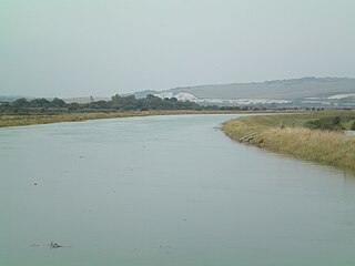
The Ouse is a 35 miles long river in the English counties of West and East Sussex. It rises near Lower Beeding in West Sussex, and flows eastwards and then southwards to reach the sea at Newhaven. It skirts Haywards Heath and passes through Lewes. It forms the main spine of an extensive network of smaller streams, of which the River Uck is the main tributary. As it nears the coast it passes through the Lewes and Laughton Levels, an area of flat, low-lying land that borders the river and another tributary, the Glynde Reach. It was a large tidal inlet at the time of the Domesday book in 1086, but over the following centuries, some attempts were made to reclaim some of the valley floor for agriculture, by building embankments, but the drainage was hampered by the buildup of a large shingle bar which formed across the mouth of the river by longshore drift.

Rodmell is a small village and civil parish in the Lewes District of East Sussex, England. It is located three miles (4.8 km) south-east of Lewes, on the Lewes to Newhaven road and six and a half miles from the City of Brighton & Hove and is situated by the west banks of the River Ouse. The village is served by Southease railway station, opened in 1906. The Prime Meridian passes just to the west of the village.

Hassocks is a village and civil parish in the Mid Sussex District of West Sussex, England. Its name is believed to derive from the tufts of grass found in the surrounding fields.

Mayfield and Five Ashes is a civil parish in the High Weald of East Sussex, England. The two villages making up the principal part of the parish lie on the A267 road between Royal Tunbridge Wells and Eastbourne: Mayfield, the larger of the two villages is ten miles (16 km) south of Royal Tunbridge Wells; with Five Ashes being 2.5 miles (4 km) further south. On 1 April 1999 the parish was renamed from "Mayfield" to "Mayfield & Five Ashes".
East Chiltington is a village and civil parish in the Lewes District of East Sussex, England. It is centred four miles (5.9 km) south-east of Burgess Hill and five miles (8 km) north-west of Lewes. It is a strip parish of 3.76 square miles (9.7 km2), stretching northward from the crest of the South Downs. The village church is 13th century in origin; the vicar also has charge of two churches in Plumpton. Near the church there is a pub called The Jolly Sportsman. The Sussex Greensand Way, a Roman road, runs from east to west through the centre of the parish.
Glynde is a village and shares a civil parish with Beddingham in the Lewes District of East Sussex, United Kingdom. It is located two miles (5 km) east of Lewes.

Iford is a village and civil parish in the Lewes District of East Sussex, England. The village is located two miles (3.2 km) south of Lewes. The parish lies on the slopes of the South Downs in the valley of the River Ouse.

Kingston near Lewes is a village and civil parish in the Lewes District of East Sussex, England. The village is mentioned in the Domesday Book and is located two miles (3.2 km) south of Lewes and is nestled in the South Downs. The parish is par of two Sites of Special Scientific Interest: the Lewes Brooks and Kingston Escarpment and Iford Hill.
St Ann Without is a civil parish in the Lewes District of East Sussex, England. It covers an area to the west of the town of Lewes, including Long Hill.

St John Without is a small civil parish in the Lewes District of East Sussex, England, covering an area to the north-west of the town of Lewes.

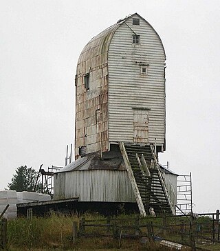
Oldland Windmill is an 18th-century post mill situated near the village of Keymer, West Sussex, England. It is a Grade II Listed Building.
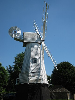
New Mill is a Grade II* listed post mill at Cross in Hand near Heathfield, East Sussex, England. It was the last windmill working commercially by wind in Sussex, ceasing work by wind in 1969 when a stock broke.
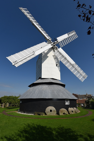
Windmill Hill Mill is a grade II* listed post mill at Herstmonceux, Sussex, England which has been restored and now operates as a working mill. The mill is open to the public on most Sundays from Easter until October.
Heritage Mill, or Beard's Mill is a grade II listed smock mill at North Chailey, Sussex, England, which is maintained as a landmark and open to the public.

Stone Cross Windmill is a grade II* listed tower mill at Stone Cross, East Sussex, England which has been restored and is open to the public. The mill was also known as Blackness Mill and the White Mill.

The Keep is a purpose-built archive and historical resource centre which stores, conserves and gives the public access to the records of its three managing partners: The East Sussex Record Office, The University of Sussex Special Collections, and Brighton & Hove Museums Local History Collections. The Keep also houses the library and office of the Sussex Family History Group, functions as headquarters of Friends of The Keep Archives, and holds the Historic Environment Record database for East Sussex. From November 2018, it has also functioned as the South East Hub for the Unlocking Our Sound Heritage project for The British Library. It was funded by East Sussex County Council, the City Council of neighbouring Brighton and Hove and the University of Sussex, and was built on land close to the university in the Moulsecoomb area of Brighton and Hove. The building, constructed with a budget of £19 million, opened on 31 October 2013, superseding the former East Sussex Record Office in the county town of Lewes.

The Bear Road area is a largely residential area in the east of Brighton, part of the English city of Brighton and Hove. Centred on the steep west–east road of that name, it is characterised by terraced houses of the early 20th century, but Brighton's main cemeteries were established here in the 19th century and there is also some industry.
Ashcombe is a village and civil parish in the Teignbridge district of Devon, England.


