
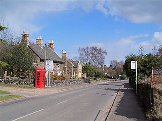
Breedon on the Hill is a village and civil parish about 5 miles (8 km) north of Ashby-de-la-Zouch in North West Leicestershire, England. The parish adjoins the Derbyshire county boundary and the village is only about 2 miles (3 km) south of the Derbyshire town of Melbourne. The 2001 Census recorded a parish population of 958 people in 404 households. The parish includes the hamlets of Tonge 1 mile (1.6 km) east of the village and Wilson 1.3 miles (2 km) north of the village on the county boundary. The population at the 2011 census was 1,029 in 450 households.

Carlton is a small rural parish located east of the River Sence in Leicestershire, England, around 2.2 miles north of Market Bosworth. According to the 2011 census, Carlton has a population of 305 However, from 2014 it is estimated that there are around 330 people living there with a total of 283 registered electors. There are four roads in Carlton:

Harborough is a local government district in Leicestershire, England. It is named after its main town, Market Harborough, which is where the council is based. The district also includes the town of Lutterworth and numerous villages and surrounding rural areas. In the north of the district it includes parts of the Leicester Urban Area, notably at Thurnby, Bushby and Scraptoft. Covering 230 square miles (600 km2), the district is the largest by area of the eight districts in Leicestershire and covers almost a quarter of the county.

Sutton Cheney is a village and former civil parish, now in the parish of Dadlington and Sutton Cheney, in the borough of Hinckley and Bosworth, in the county of Leicestershire, England, near the county border with Warwickshire. In addition to the village of Sutton Cheney itself, the civil parish also contains the villages of Dadlington and Shenton, a number of farms, and the location of the Battle of Bosworth. Its closest large towns are Nuneaton and Hinckley. Its closest market town is Market Bosworth.

Houghton on the Hill is a village and civil parish lying six miles (10 km) to the east of Leicester in the Harborough district, in Leicestershire, East Midlands in England. The population of the civil parish at the 2011 census was 1,524.

Anstey is a large village in Leicestershire, England, located north west of Leicester in the borough of Charnwood. Its population was 9,000 at the 2021 census. This figure is expected to increase due to the building of a new housing development off Groby Road. The village is separated from Leicester by the Rothley Brook, Castle Hill Park and the A46, and it borders the villages of Glenfield, Groby, Newtown Linford, Cropston and Thurcaston as well as the suburb of Beaumont Leys and Anstey Heights. To the north-west lies Bradgate Park.
Swithland is a linear village in the Charnwood borough of Leicestershire, England. The civil parish population was put at 230 in 2004 and 217 in the 2011 census. It is in the old Charnwood Forest, between Cropston, Woodhouse and Woodhouse Eaves. It has a village hall, a parish church and a public house, the Griffin Inn. The village is known for the slate that was quarried in the area.

Ratby is a commuter village and civil parish in the Hinckley and Bosworth district of Leicestershire, England. It is situated to the west of Leicester, and just south of the M1 motorway. The population of the civil parish was measured in the 2011 census as 4,468. Other nearby places include Field Head, Kirby Muxloe, Glenfield and Markfield. The proximity of Ratby to Leicester causes it to form part of the Leicester Urban Area.

Foxton is a village and civil parish in the Harborough district, in the county of Leicestershire, England, to the north-west of Market Harborough. The village is on the Grand Union Canal and is a short walk to the site of the Foxton Locks and Foxton Inclined Plane. Swingbridge Street still has a working swing bridge that allows people and vehicles to pass over the canal, which can be opened to allow canal boats to pass. There are two public houses in the village, a village hall, and a primary school. Foxton is serviced by Market Harborough train station which is approximately 3 miles away. London and Birmingham can each be reached by train in approximately 50 minutes.

Knaptoft is a deserted medieval village and civil parish in the Harborough district of Leicestershire and lies approximately 9.7 miles (15.6 km) south of the city of Leicester, England. According to the University of Nottingham English Place-names project, the settlement name Knaptoft could mean "cnafa" for 'a boy, a young man, a servant, a menial, or a personal name' and 'toft', the plot of ground in which a dwelling stands. The population of the civil parish at the 2011 census was 47.

Mowsley, pronounced "mowzley" is a small village in the south part of Leicestershire. The modern village has just under 100 dwellings. The population at the 2011 census the population was 302.

Sharnford is a village and civil parish in the Blaby district of Leicestershire, England. The parish has a population of about 1,000, measured at the 2011 census as 985. The village is about four miles east of Hinckley, and is near to Aston Flamville, Wigston Parva and Sapcote.

Beeby is a village and civil parish in the Charnwood district of Leicestershire, England, with a population of 115 according to the 2011 census. It is situated north-east of Leicester, nearer to the villages of Keyham and Hungarton in the neighbouring district of Harborough and lies along the Barkby Brook. This small rural hamlet can be succinctly described as "a series of scattered houses that remain of the shrunken medieval village". The parish also includes the hamlet of Little Beeby, which consists of several houses within the settlement and is located 200m south east of the All Saints Church.

Stockerston is a village and civil parish in the Harborough district of Leicestershire, England, located on the border with Rutland, by the Eye Brook. According to the 2001 census the parish had a population of 35. The population remained less than 100 at the 2011 census and is included in the civil parish of Horninghold.

Willoughby Waterleys is a small village and civil parish in the Harborough district of Leicestershire, England. It is situated near the A426 Leicester–to–Lutterworth road. Nearby villages are Ashby Magna, Peatling Magna and Countesthorpe. Main Street is the basis of the village running north to south, there have been some new developments such as bungalows and large detached houses however many farms still remain in the parish.
Laughton en le Morthen is a village and civil parish in the Metropolitan Borough of Rotherham lying to the south of Rotherham, South Yorkshire, England, and its main attraction is the All Saints Church with its tower and spire of 185 feet. The village had a population of 1,241 at the 2011 Census. The parish also includes the hamlets of Carr, Slade Hooton and Brookhouse.
Newton Harcourt is a village and former civil parish, now in the parish of Wistow, in the Harborough district, in the English county of Leicestershire, and lies 7 miles south-east of the city of Leicester on the northern ridge of the River Sence valley. In 1931 the parish had a population of 142.
Chadwell is a small village in the district of Melton, which is approximately 4 miles (6.4 km) northeast of Melton Mowbray in Leicestershire, and is part of the civil parish of Scalford, which also includes the neighbouring hamlet of Wycomb. Until 1 April 1936 it was in the parish of Wycomb and Chadwell. The village name means 'spring/stream which is cold'. Chadwell is half a mile east of Wycomb, and they share the Church of St. Mary in the same ecclesiastical parish. The Church of St Mary is a Grade II* listed building.

Scotter is a large village and civil parish in West Lindsey, Lincolnshire, England, situated between Scunthorpe and Gainsborough.

Laughton is a village and a civil parish in the West Lindsey district of Lincolnshire, England. The population of the civil parish at the 2011 census was 410. It is situated approximately 6 miles (10 km) north from the town of Gainsborough

