Gumley

Last updated

Gumley
GUMLEY,LEICESTERSHIRE.jpg
St. Helen's Church, Gumley
Leicestershire UK location map.svg
Red pog.svg
Gumley
Location within Leicestershire
Population209 (2011)
OS grid reference SP6817190018
District
Shire county
Region
Country England
Sovereign state United Kingdom
Post town MARKET HARBOROUGH
Postcode district LE16
Dialling code 01858
Police Leicestershire
Fire Leicestershire
Ambulance East Midlands
UK Parliament
List of places
UK
England
Leicestershire
52°30′16″N1°00′00″W / 52.504528°N 1.000130°W / 52.504528; -1.000130 Coordinates: 52°30′16″N1°00′00″W / 52.504528°N 1.000130°W / 52.504528; -1.000130

Gumley is a village and civil parish in the Harborough district, in the county of Leicestershire, England, United Kingdom. The closest town is Market Harborough. The population of the civil parish (including Laughton, Leics) at the 2011 census was 209. [1]

Contents

The name Gumley is a contraction of the Anglo-Saxon "Gutmundesleah" – meaning Godmund's clearing. [2]

History

The village is first mentioned in 749. King Æthelbald of Mercia (r.716-757) held a synod at Gumley in that year, at the instigation of Saint Boniface, to answer accusations that he had been oppressing churches and monasteries. The outcome was that Æthelbald released the Church from all public burdens except the three common burdens of providing military service, and building and repairing bridges and fortresses. These obligations arguably initiated changes in the land tenurial system of England and eventually led to serfdom.

King Offa visited Gumley in 772 and 779 for the witanagemot of the kings of Mercia. On the south side of Gumley Covert there is a pond called "the Mot" which may be a Saxon site. The pond stands in a small natural amphitheatre near a mound surmounted with trees. [3]

After the Norman Conquest Gumley was given to Countess Judith, the Conqueror's niece. At that time there were twenty inhabitants. In the medieval period there were dwellings below the village towards Thornhill Farm, of which little remains apart from some surface irregularities and cobbles on the footpath passing by Too Cottage. There were also houses by the 'holloways' in Crow Spinney beside the parish church.

Gumley's population peaked in 1821 when 281 residents were engaged working the land as well as making lace and stockings. Now there are about 105 people on the electoral roll.

Because Gumley has been surrounded by pasture predominantly, the medieval ridge and furrow method of working the land is particularly well preserved and its fields are subject to preservation orders.

Gumley Hall

Gumley Hall was built in 1764 for Joseph Cradock (d. 1826). It consists of a large three storey red brick central block, flanked by two-story pavilions connected to the main block by quadrant walls. Internally many of the features, including the main staircase with its cast-iron balustrade, appear to date from the earlier 19th century. These were probably inserted between 1823 and 1833 by Sir Edmund Cradock-Hartopp who apparently took over the house in an unfinished condition. South of the hall and opening upon the village street the red-brick stables built round a courtyard were erected by Capt. Whitmore; the clock tower in the style of an Italian campanile bears the inscription Incorrupta Fides and a weathercock dated 1870. [3]

Cradock laid out the gardens and plantations of Gumley Hall in imitation of the Parc de Saint-Cloud, and in the summer months they became a fashionable resort for the gentry of Leicester, particularly those who came to take the mineral waters of its 'spa', a chalybeate spring found in 1789. [3]

Cradock moved in the literary society of Goldsmith, Johnson, and Burke, and built a theatre at Gumley which was used for amateur productions and by Garrick. The owners of Gumley Hall in the 19th century, were not always resident. There were at least two periods when the hall was in the hands of tenants-the 1860s and the 1890s. The Cradock-Hartopps let it to Lt.-Col. Dottin Maycock (1816–79) before he moved to Foxton Lodge, and then to Viscount Ingestre (1830–77) before he succeeded as 19th Earl of Shrewsbury in 1868. [3]

After many structural alterations in 1869-70, the new owner, Capt. Whitmore, came into residence. From c. 1890, when he moved to Essex, he let the hall to a succession of tenants: Thomas Keay Tapling (1855–91), M.P. for South Leicestershire; James Coats (1834–1913), of J. & P. Coats, Ltd.; and from 1893 Mrs. Emma Bellville, who afterwards moved to Stoughton Grange. In 1897 the hall was bought by the Murray Smiths, who lived there until 1940. One of their governesses was Evelyn Cheesman, later a celebrated entomologist and traveller. G. A. Murray Smith then moved into the Rectory, which was no longer required by the incumbent. [3]

During the Second World War the Hall was used to train resistance fighters and Special Operations Executive and afterwards Leonard Cheshire was given the use of the Hall for those servicemen returning homeless after demobilisation. The Hall became increasingly dilapidated and was demolished in 1964.

Other buildings

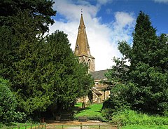
St Helen's Church mostly dates from the 14th century with later additions. The tenor bell was cast around 1520. The interior of the church was restored in the Victorian era in 1874 and is a good example of the Decorative style. There is a service every Sunday with a family service once a month.

At the Engine House gas was manufactured for the Hall. There was a Post Office and part of the bakery remains as outbuildings of Westfield. The Butchers shop was at the 'Js' where it was preserved as a museum until recently. There were two public houses in the 1840s, the Hartopp Arms and the Bluebell, which later became The Bell. Only two of seven farms in Gumley are left.

Grade 2 listed structures in the village include Hall Farm, Rose Cottage and Fenleigh House, Stone House, Leys Farm and the village pump. The Motte Castle, a tree ringed mound to the west of Gumley is a Scheduled Monument.

The Village Hall was opened in 1969 on the site of Gumley's former school, which closed in 1933. It is run as a charitable trust and has a small committee open to anyone from the village who cares to join. There is a fish and chips evening in February and a summer barbecue in August as well as other social events.

Village activities

Gumley Women's Institute was founded in 1918 and is one of the oldest in the whole country. Meetings are still held most months in the Village Hall.

The Fernie Hunt, founded in 1853, traditionally holds its opening meet in Gumley in October. [4]

Gumley Cricket Club is a village cricket team based in Gumley, Leicestershire, England. The club has two senior teams, the Saturday XI currently play in the Leicestershire and Rutland Cricket League [5] and a Sunday XI team that play friendly fixtures against an established selection of clubs. [6]

Related Research Articles

Market Harborough Human settlement in England

Market Harborough is a market town in the Harborough district of Leicestershire, England, in the far southeast of the county, forming part of the border with Northamptonshire.

Harborough District District in England

Harborough is a local government district of Leicestershire, England, named after its main town, Market Harborough. Covering 230 square miles (600 km2), the district is by far the largest of the eight district authorities in Leicestershire and covers almost a quarter of the county.

Houghton on the Hill Village near Leicester, England

Houghton on the Hill is a village and civil parish lying six miles (10 km) to the east of Leicester in the Harborough district, in Leicestershire, East Midlands in England. The population of the civil parish at the 2011 census was 1,524.

Marston Trussell Human settlement in England

Marston Trussell is a village and civil parish in West Northamptonshire in England. Marston Trussell was first recorded as 'Mersitone', meaning marsh settlement. The parish includes Thorpe Lubenham. At the time of the 2001 census, its population was 163 people, reducing slightly to 157 at the 2011 census but including Lubenham.

Anstey, Leicestershire Human settlement in England

Anstey is a large village in Leicestershire, England, located north west of Leicester in the borough of Charnwood. Its population was 6,528 at the 2011 census. This figure is expected to increase due to the building of a new housing development off Groby Road. The village is separated from Leicester by the Rothley Brook, Castle Hill Park and the A46, and it borders the villages of Glenfield, Groby, Newtown Linford, Cropston and Thurcaston as well as the suburb of Beaumont Leys and Anstey Heights. To the north-west lies Bradgate Park.

Great Glen, Leicestershire Human settlement in England

Great Glen is a village and civil parish in the Harborough district, in Leicestershire, 2 miles south of Oadby. The population of the civil parish at the 2011 census was 3,662. Leicester city centre is about seven miles north west. Its name comes from the original Iron Age settlers who used the Celtic word glennos meaning valley, and comes from the fact that Great Glen lies in part of the valley of the River Sence. The 'great' part is to distinguish the village from Glen Parva.

Guthlac of Crowland 8th-century Christian saint and hermit

Saint Guthlac of Crowland was a Christian saint from Lincolnshire in England. He is particularly venerated in the Fens of eastern England.

Bringhurst Human settlement in England

Bringhurst is a small village and civil parish in the Harborough district of south-east Leicestershire, bordering Northamptonshire and Rutland. Nearby places are Cottingham in Northants, Great Easton and Drayton in Leicestershire, and Caldecott in Rutland. The population is included in the civil parish of Great Easton.

Fleckney Human settlement in England

Fleckney is a village and civil parish in the Harborough district of Leicestershire, England. It is situated 2.5 miles (4 km) west of the A6 national route between Market Harborough and Leicester.

Foxton, Leicestershire Village in Leicestershire, England

Foxton is a village and civil parish in the Harborough district, in the county of Leicestershire, England, to the north-west of Market Harborough. The village is on the Grand Union Canal and is a short walk to the site of the Foxton Locks and Foxton Inclined Plane. Swingbridge Street still has a working swing bridge that allows people and vehicles to pass over the canal, which can be opened to allow canal boats to pass. There are two public houses in the village, a village hall, and a primary school. Foxton is serviced by Market Harborough train station which is approximately 3 miles away. London and Birmingham can each be reached by train in approximately 50 minutes.

Arnesby

Arnesby is a village and civil parish in the Harborough district of Leicestershire, England. According to the 2001 census the parish had a population of 343, increasing to 357 at the 2011 census. The village is situated 8 miles (13 km) south-east of Leicester, on the Welford Road, between Kilby and Shearsby.

Freeby Human settlement in England

Freeby is a village and civil parish in the Melton district of Leicestershire, England, about 3 miles (5 km) east of Melton Mowbray. As well as the village of Freeby the civil parish includes the villages of Brentingby, Saxby, Stapleford and Wyfordby. The 2011 Census recorded the parish population as 244.

Robert Smyth Academy Academy - converter mainstream school in Market Harborough, Leicestershire, England

The Robert Smyth Academy is a secondary school in Market Harborough, Leicestershire, England for 11- to 19-year-olds. It is situated in the north of the town, on Burnmill Road, close to St Luke's Hospital.

Willoughby Waterleys Human settlement in England

Willoughby Waterleys is a small village and civil parish in the Harborough district of Leicestershire, England. It is situated near the A426 Leicester–to–Lutterworth road. Nearby villages are Ashby Magna, Peatling Magna and Countesthorpe. Main Street is the basis of the village running north to south, there have been some new developments such as bungalows and large detached houses however many farms still remain in the parish.

Cradock-Hartopp baronets

The Cradock-Hartopp Baronetcy, of Freathby in the County of Leicester and of Four Oaks Hall in the County of Warwick, was a title in the Baronetage of Great Britain. It was created on 12 May 1796 for Edmund Cradock-Hartopp, Member of Parliament for Leicestershire. Born Edmund Bunney, he was the husband of Anne Hurlock, granddaughter and heiress of Sir John Hartopp, 4th Baronet, of Freathby. On his marriage in 1777 he assumed the surname of Cradock-Hartopp in lieu of his patronymic according to the wills of his uncle Joseph Cradock and his wife's grandfather. His eldest surviving son Edmund, the second Baronet, died childless and was succeeded by his younger brother, William, the third Baronet. The title then descended from father to son until the death of his grandson, Charles, the fifth Baronet, in 1929.

This is a list of Sheriffs and High Sheriffs of Leicestershire, United Kingdom. The Sheriff is the oldest secular office under the Crown. Formerly the High Sheriff was the principal law enforcement officer in the county but over the centuries most of the responsibilities associated with the post have been transferred elsewhere or are now defunct, so that its functions are now largely ceremonial. Under the provisions of the Local Government Act 1972, on 1 April 1974 the office previously known as Sheriff was retitled High Sheriff. The High Sheriff changes every March.

Gumley Cricket Club is an amateur cricket club based in Gumley, Leicestershire, England. The club has three senior teams. The Saturday XI, having traditionally played friendlies, started playing competative cricket in 2009, in the Northamptonshire Cricket League. A Sunday XI side plays friendly fixtures against an established selection of clubs in and around the region. A Midweek XI compete in the Market Harborough District Midweek Evening League and Knockout competitions.

Saddington Human settlement in England

Saddington is a village in the Harborough district of Leicestershire, England. It is close to Smeeton Westerby, Gumley, Kibworth and Fleckney. The population of the civil parish at the 2011 census was 309.

Frolesworth Human settlement in England

Frolesworth is a small village and civil parish in the Harborough district of Leicestershire, England. It lies four miles north of Lutterworth, three from Broughton Astley and eighteen miles west of Market Harborough. The population is included in the Thurlaston civil parish.

Willoughby Waterleys Cricket Club

Willoughby Waterleys Cricket Club is an amateur cricket club that up until recently was based at Dunton Bassett Cricket Club, Dunton Bassett, Leicestershire.

References

  1. "Civil Parish population 2011". Neighbourhood Statistics. Office for National Statistics. Archived from the original on 11 October 2016. Retrieved 13 June 2016.
  2. "Key to English Place-names". kepn.nottingham.ac.uk. Archived from the original on 30 June 2021. Retrieved 9 September 2021.
  3. 1 2 3 4 5 'Gumley', A History of the County of Leicestershire: Volume 5 : Gartree Hundred. 1964. pp. 116–121. Archived from the original on 25 May 2011. Retrieved 13 April 2011.
  4. "Fernie Hunt". leicestershirecountyshow.co.uk. 22 June 2017. Archived from the original on 6 August 2020. Retrieved 5 May 2021.
  5. "Gumley Cricket Club 1st XI Team". gumley.play-cricket.com. Archived from the original on 9 September 2021. Retrieved 5 May 2021.
  6. "Gumley Cricket Club". gumley.play-cricket.com. Archived from the original on 1 September 2019. Retrieved 5 May 2021.