The Pennyroyal Plateau or Pennyroyal Region, often spelled Pennyrile, is a large physiographic region of Kentucky that features rolling hills, caves, and karst topography in general. It is named for Hedeoma pulegioides, a wild mint that grows in the area. It is also called the "Mississippian Plateau," for the Mississippian geologic age in which it was formed.

An inselberg or monadnock is an isolated rock hill, knob, ridge, or small mountain that rises abruptly from a gently sloping or virtually level surrounding plain. In Southern Africa a similar formation of granite is known as a koppie, an Afrikaans word from the Dutch diminutive word kopje. If the inselberg is dome-shaped and formed from granite or gneiss, it can also be called a bornhardt, though not all bornhardts are inselbergs. An inselberg results when a body of rock resistant to erosion, such as granite, occurring within a body of softer rocks, is exposed by differential erosion and lowering of the surrounding landscape.

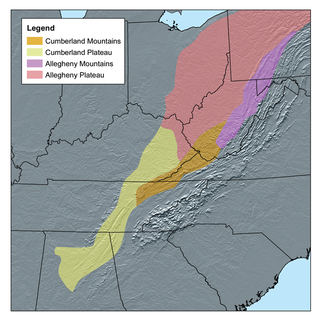
The Cumberland Plateau is the southern part of the Appalachian Plateau in the Appalachian Mountains of the United States. It includes much of eastern Kentucky and Tennessee, and portions of northern Alabama and northwest Georgia. The terms "Allegheny Plateau" and the "Cumberland Plateau" both refer to the dissected plateau lands lying west of the main Appalachian Mountains. The terms stem from historical usage rather than geological difference, so there is no strict dividing line between the two. Two major rivers share the names of the plateaus, with the Allegheny River rising in the Allegheny Plateau and the Cumberland River rising in the Cumberland Plateau in Harlan County, Kentucky.

Massanutten Mountain is a synclinal ridge in the Ridge-and-Valley Appalachians, located in the U.S. state of Virginia.

The Southeast Missouri Lead District, commonly called the Lead Belt, is a lead mining district in the southeastern part of Missouri. Counties in the Lead Belt include Saint Francois, Crawford, Dent, Iron, Madison, Reynolds, and Washington. This mining district is the most important and critical lead producer in the United States.
Floyds Knobs is a small unincorporated community in Lafayette Township, Floyd County, Indiana, United States. Historically a farming community on the outskirts of New Albany, it has since become a bedroom community for Louisville, Kentucky. It contains subdivisions, farms, small shopping centers, churches, and transmitters for many of the area's television and radio stations. It is also the location of Floyd Central High School. There is a population of about 11,412 to 12,439.

The Knobs Region or The Knobs is located in the US state of Kentucky. It is a narrow, arc-shaped region consisting of hundreds of isolated hills. The region wraps around the southern and eastern parts of the Bluegrass region in the north central to northeastern part of the state. The western end of the Knobs region begins near Louisville, Kentucky and continues southeastward through Bullitt, Hardin, Nelson, LaRue, Marion County, Taylor, Boyle, Casey, Lincoln, and Garrard counties before turning northeast and running along the Pottsville Escarpment and the Appalachian Plateau. The Knob arc has a length of 230 miles (370 km).

The Big Clifty Sandstone is a geologic formation in Illinois and Kentucky. It is a subunit of the Golconda Formation in Kentucky and is correlative with the Fraileys Shale to which it grades to in southern Illinois. The Big Clifty and Golconda are part of the Chesterian Series of late Mississippian age. The Big Clifty Sandstone was deposited in deltaic to marginal marine environment by the paleo Michigan River which in modern directions flowed south from the Canadian shield, the sediment source, and then westward depositing sediment across Illinois, Kentucky, and Indiana, as the Big Clifty Formation of the Stephensport Group. At Mammoth Cave National Park the Big Clifty overlies the Girkin Formation, the uppermost of three cave forming carbonate formations which the Mammoth-Flint Ridge cave system spans. Below the Girkin Formation are the Ste. Genevieve Limestone, and the St. Louis Limestone respectively. The chemically resistant sediments comprising the Big Clifty, and similar siliciclastics, act as a caprock over the dissolving carbonates. The presence of the Big Clifty is one of several contributory factors that create favorable conditions for the formation, and subsequent preservation, of connected cavernous porosity in the Mammoth-Flint Ridge cave system.

Blue Knob is a summit in the eastern United States with a broad dome that is the northernmost 3,000-footer in the Allegheny Mountains. It is the highest point in Bedford County, Pennsylvania.

Butler Knob is a peak on the Jacks Mountain ridge in south central Pennsylvania in the United States. The "Knobs" summit is underlain with weather resistant quartzite of the Tuscarora Formation. Butler Knob is accessible by a rough road, where there is a closed firetower on the summit. The firetower presently hold a weather station that gives current forecasts for the area.

The Silurian Tuscarora Formation — also known as Tuscarora Sandstone or Tuscarora Quartzite — is a mapped bedrock unit in Pennsylvania, Maryland, West Virginia, and Virginia, US.
For other "River Knobs", see River Knobs (disambiguation).
Purcell Knob is a spur of the Blue Ridge Mountain in Loudoun County, Virginia. The 1,207 feet (368 m) peak is just northeast of the main ridge at Keyes Gap and southeast of the village of Neersville.

Pilot Knob is located in the Arcadia Valley of Iron County, Missouri, between the towns of Ironton and Pilot Knob. Pilot Knob, so named because of its distinctive shape and prominent position, reaches an elevation of 1,470 feet (450 m) rising 581 feet (177 m) above the Arcadia Valley floor and has a large deposit of iron ore in its upper regions. Pilot Knob is a peak in the St. Francois Mountains.

The Mississippian Borden Formation is a mapped bedrock unit in Kentucky, Indiana, Illinois, Ohio, West Virginia, and Tennessee. It has many members, which has led some geologists to consider it a group rather than a formation.

The Waldron Shale is a geologic formation in Indiana. It preserves fossils dating back to the Silurian period. These fossils comprise at least three different benthic communities primarily living in the inter-reef, deep waters that were stable for much of the Wenlockian epoch. Many of these fossils are found most frequently around microbioherms constructed by small encrusting organisms which protected other species from the effects of storms.
Knob Hill is an unincorporated community in Center Township, Vanderburgh County, in the U.S. state of Indiana.
The Weverton Formation is a quartzite geologic formation in Maryland, Virginia, West Virginia, and Pennsylvania. It is considered the basal member of the Chilhowee Group. The Weverton Formation dates back to the Cambrian period.
The New Harmony Group is located in the State of Indiana. It is made up of three formations, the Grassy Knob Chert, the Backbone Limestone and Clear Creek Chert. It is Lower Devonian in age.


