| Borden Formation | |
|---|---|
| Stratigraphic range: Mississippian | |
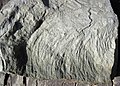
 Turbidites of Farmers Member of Borden Formation at mile marker 135, Interstate 64, Kentucky | |
| Type | Sedimentary |
| Sub-units | Kentucky: |
| Thickness | Kentucky: 0–200 m (0–656 ft) [5] |
| Lithology | |
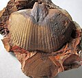
| Primary | Shale, siltstone, sandstone |
| Other | Limestone |
| Location | |
| Region | Kentucky, Indiana, Illinois, Ohio, West Virginia, Tennessee |
| Country | United States |
| Extent | Cincinnati Arch, Appalachian Basin, Illinois Basin |
| Type section | |
| Named for | Borden, Clark County, Indiana |
| Named by | Cummings |
| Year defined | 1922 [6] |
Wikimedia Commons has media related to Borden Formation .
The Mississippian Borden Group (sometimes Borden Formation) is a mapped bedrock unit in Kentucky, Indiana, Illinois, Ohio, West Virginia, [7] and Tennessee. It has many members, which has led some geologists to consider it a group (for example in Indiana [8] ) rather than a formation (for example in Kentucky [1] [4] ).