Spilsby Rural District

Last updated

Spilsby
Spilsby Rural District, Lindsey (1970).svg
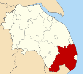
Spilsby Rural District shown within Parts of Lindsey in 1970.
Area
  1901128,211 acres (518.9 km2)
  1961145,660 acres (589.5 km2)
Population
  190120,506
  197122,459
History
  Created1894
  Abolished1974
  Succeeded by East Lindsey
Status Rural district
   HQ Spilsby

Spilsby was a rural district in Lincolnshire, parts of Lindsey from 1894 to 1974.

It was created by the Local Government Act 1894 from the Spilsby rural sanitary district. Due to growth in other areas, it was reduced three times: in 1896 when Alford was constituted an urban district; in 1925 when the civil parish of Sutton in the Marsh became part of Mablethorpe and Sutton Urban District; and in 1926, when the neighbouring Skegness Urban District was extended. In 1936 a County Review Order enlarged the district when it absorbed the former Sibsey Rural District.

It survived until 1974. Under the Local Government Act 1972, it was merged with other districts to form the new East Lindsey district.

Civil parishes

The rural district contained the following civil parishes:

Related Research Articles

<span class="mw-page-title-main">Alford, Lincolnshire</span> Town in East Lindsey district of Lincolnshire, England

Alford is a town in the East Lindsey district of Lincolnshire, England, at the foot of the Lincolnshire Wolds, which form an Area of Outstanding Natural Beauty. The population was recorded as 3,459 in the 2011 Census and estimated at 3,789 in 2019. It lies between the towns of Mablethorpe, Louth, Spilsby, and Skegness and acts as a local retail centre.

<span class="mw-page-title-main">East Lindsey</span> Non-metropolitan district in England

East Lindsey is a local government district in Lincolnshire, England. The population of the district council was 142,300 at the 2021 census. The council is based in Horncastle having moved from its former headquarters at Manby in December 2022. Other major settlements in the district include Alford, Wragby, Spilsby, Mablethorpe, Skegness, Horncastle, Chapel St Leonards, Louth and Woodhall Spa. Skegness is the largest town in East Lindsey, followed by Louth.

<span class="mw-page-title-main">Parts of Lindsey</span> Historic division of Lincolnshire, England

The Parts of Lindsey are a traditional division of Lincolnshire, England, covering the northern part of the county. The Isle of Axholme, which is on the west side of the River Trent, has normally formed part of it. The district's name originated from the Kingdom of Lindsey of Anglo-Saxon times, whose territories were merged with that of Stamford to form Lincolnshire.

<span class="mw-page-title-main">Spilsby</span> Market town and civil parish in Lincolnshire, England

Spilsby is a market town, civil parish and electoral ward in the East Lindsey district of Lincolnshire, England. The town is adjacent to the main A16, 33 miles (53 km) east of the county town of Lincoln, 17 miles (27 km) north-east of Boston and 13 miles (21 km) north-west of Skegness. It lies at the southern edge of the Lincolnshire Wolds and north of the Fenlands, and is surrounded by scenic walking, nature reserves and other places to visit.

<span class="mw-page-title-main">Mablethorpe</span> Seaside town in East Lindsey, Lincolnshire

Mablethorpe is a seaside town in the East Lindsey district of Lincolnshire, England, part of the civil parish of Mablethorpe and Sutton. The population including nearby Sutton-on-Sea was 12,531 at the 2011 census and estimated at 12,633 in 2019. The town was visited regularly by Alfred, Lord Tennyson, a 19th-century Poet Laureate of the United Kingdom. Some town features have been named after him, such as Tennyson Road and the now closed Tennyson High School.

<span class="mw-page-title-main">Louth and Horncastle (UK Parliament constituency)</span> Parliamentary constituency in the United Kingdom, 1997 onwards

Louth and Horncastle is a constituency in Lincolnshire represented in the House of Commons of the UK Parliament by Victoria Atkins, a Conservative.

<span class="mw-page-title-main">Wainfleet All Saints</span> Ancient port and market town in Lincolnshire, England

Wainfleet All Saints is an ancient port and market town on the east coast of England, in the East Lindsey district of Lincolnshire, on the A52 road 5 miles (8 km) south-west of Skegness and 14 miles (23 km) north-east of Boston. It stands on two small rivers, the Steeping and Limb, that form Wainfleet Haven. The town is close to the Lincolnshire Wolds. The village of Wainfleet St Mary is to the south.

Mablethorpe and Sutton is a civil parish and town in East Lindsey, Lincolnshire, England. It is on the North Sea coast and includes Mablethorpe, Trusthorpe, Sutton-on-Sea and Sandilands along with the inland village of Thorpe. According to the 2001 census it had a population of 11,780, increasing to 12,531 at the 2011 Census.

<span class="mw-page-title-main">Firsby</span> Small rural linear village and civil parish in the East Lindsey district of Lincolnshire, England

Firsby is a small rural linear village and civil parish in the East Lindsey district of Lincolnshire, England. It is situated 30 miles (48 km) east from the city and county town of Lincoln, 4 miles (6.4 km) south-east from the nearest market town of Spilsby, and 7 miles (11 km) inland from the holiday resort town of Skegness.

Horncastle was a county constituency in Lincolnshire which returned one Member of Parliament (MP) to the House of Commons of the Parliament of the United Kingdom. MPs were elected by the first past the post system of voting.

East Lindsey was a county constituency based on the East Lindsey local government district of Lincolnshire. It returned one Member of Parliament (MP) to the House of Commons of the Parliament of the United Kingdom.

<span class="mw-page-title-main">Keal Cotes</span> Small linear village in East Lindsey district of Lincolnshire, England

Keal Cotes, forming part of West Keal parish, is a small linear village in East Lindsey district of Lincolnshire, England. It is situated on the A16 road, 1 mile (1.6 km) south from West Keal and 1 mile north from Stickford. The nearest market town is Spilsby, about 6 miles (10 km) to the north. Keal Cotes market day is on Mondays.

<span class="mw-page-title-main">East Lincolnshire Railway</span> Railway in England

The East Lincolnshire Railway was a main line railway linking the towns of Boston, Louth and Grimsby in Lincolnshire, England. It opened in 1848. The ELR Company had leased the line to the Great Northern Railway, and it was the latter which constructed the line and operated it, as its East Lincolnshire Line.

<span class="mw-page-title-main">Toynton Fen Side</span> Hamlet and linear settlement on Fenside Road in the East Lindsey district of Lincolnshire, England

Toynton Fen Side is a hamlet and linear settlement on Fenside Road in the East Lindsey district of Lincolnshire, England. The hamlet is partly in the civil parish of Toynton St Peter, and that of Toynton All Saints. Toynton Fen Side is situated 12 miles (19 km) north from Boston and 11 miles (18 km) west from Skegness. The East Fen Catchwater Drain crosses west to east at the south of the hamlet. Bus services connect Toynton Fen Side with Horncastle, Partney, Wainfleet, Boston, Mablethorpe, and Spilsby. Businesses include garage services and a fencing suppliers.

<span class="mw-page-title-main">Mablethorpe loop railway</span> Railway in Lincolnshire, England

The Mablethorpe Loop railway was formed in Lincolnshire, England, by two independent railway companies, which built branches from the East Lincolnshire Line.

<span class="mw-page-title-main">Willoughby with Sloothby</span> Human settlement in England

Willoughby with Sloothby is a civil parish in the East Lindsey district of Lincolnshire in the East Midlands of England. The parish includes the settlements of Willoughby and Sloothby as well as the hamlets and villages of Bonthorpe, Mawthorpe, Hasthorpe and Habertoft. The parish covers quite a large area of East Lindsey with the towns of Alford, Mablethorpe, Spilsby, Skegness and Burgh le Marsh situated near the parish. The parish's nearest railway station is Skegness. The village of Willoughby was served by a station on the former East Lincolnshire Railway and Mablethorpe Loop Line. However, it closed in 1970 and so did the lines. The station master's house and a section of platform and goods shed survive near the site.

References

Coordinates: 53°10′N0°06′E / 53.17°N 0.10°E / 53.17; 0.10