
Sausthorpe is a small village and civil parish in the East Lindsey district of Lincolnshire, England, 8 miles (13 km) east of Horncastle and 3 miles (4.8 km) north-west of Spilsby. It lies on the southern edge of the Lincolnshire Wolds – a designated Area of Outstanding Natural Beauty – in the valley of the River Lymn. Farming remains the dominant economic activity in the area. The population was 305 in the 2011 census and estimated at 306 in 2019.

In the United Kingdom, a deserted medieval village (DMV) is a former settlement which was abandoned during the Middle Ages, typically leaving no trace apart from earthworks or cropmarks. If there are fewer than three inhabited houses the convention is to regard the site as deserted; if there are more than three houses, it is regarded as a shrunken medieval village. There are estimated to be more than 3,000 DMVs in England alone.

Caistor is a town and civil parish in the West Lindsey district of Lincolnshire, England. As its name implies, it was originally a Roman castrum or fortress. It lies at the north-west edge of the Lincolnshire Wolds, on the Viking Way, and just off the A46 between Lincoln and Grimsby, at the A46, A1084, A1173 and B1225 junction. It has a population of 2,601. Its name comes from the Anglo-Saxon ceaster and was given in the Domesday Book of 1086 as Castre.
Flixborough is a village and civil parish in North Lincolnshire, England. The population at the 2011 census was 1,664. It is near the River Trent, 3 miles (5 km) north-west from Scunthorpe. The village is noted for the 1974 Flixborough disaster.

Ashby by Partney is a village and former civil parish, now in the parish of Ashby with Scremby, in the East Lindsey district of Lincolnshire, England. It is situated to the south of the A158 road, and 2 miles (3 km) east from the town of Spilsby. It neighbours the village of Partney. In 1961 the parish had a population of 64. On 1 April 1987 the parish was abolished and merged with Scremby to form "Ashby with Scremby".

Laceby is a village and civil parish in North East Lincolnshire, England. It is situated on the A46 road, just outside the western boundary of Grimsby. Laceby's population at the 2001 Census was 2,886, increasing to 3,259 at the 2011 Census. The village is noted for its parish church of St Margaret's, parts of which date to the 12th century.

Ashby with Scremby is a civil parish in the East Lindsey district of Lincolnshire, England, with a population of 147, increasing to 179 at the 2011 census. The parish includes the village of Scremby, along with the hamlets of Ashby by Partney and Grebby.

Wainfleet All Saints is an ancient port, market town and civil parish on the east coast of England, in the East Lindsey district of Lincolnshire, on the A52 road 5 miles (8 km) south-west of Skegness and 14 miles (23 km) north-east of Boston. It stands on two small rivers, the Steeping and Limb, that form Wainfleet Haven. The town is close to the Lincolnshire Wolds. The village of Wainfleet St Mary is to the south. In 2011 the parish had a population of 1604.

Lyminge is a village and civil parish in southeast Kent, England. It lies about five miles (8 km) from Folkestone and the Channel Tunnel, on the road passing through the Elham Valley. At the 2011 Census the population of Etchinghill was included. The Nailbourne stream begins in the village and flows north through the Valley, to become one of the tributary streams of the Great Stour. The hamlet of Ottinge lies to the NE on the road to Elham. Lyminge is home to the Grade II* listed Sibton Park, now owned by the Holiday Property Bond but previously a school.

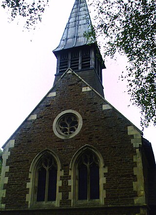
Partney is a small village and civil parish in the East Lindsey district of Lincolnshire, England. It is situated 3 miles (4.8 km) north of Spilsby, and in the Lincolnshire Wolds. The village was the birthplace of Henry Stubbe, the noted 17th-century Intellectual.
Fillingham is a village and civil parish in the West Lindsey district of Lincolnshire, England. It is situated 9 miles (14.5 km) north from the city and county town of Lincoln, and just over 1 mile (1.6 km) west from the A15 road.

Skendleby is a small village and civil parish in the East Lindsey district of Lincolnshire, England. It is situated near to the A158 and lies 35 miles (56 km) east from the county town Lincoln, and about 4 miles (6 km) north-east from the town of Spilsby. The village stands near the south-eastern edge of the Lincolnshire Wolds.

St Peter's Church is the former parish church of Barton-upon-Humber in North Lincolnshire, England. It is one of the best known Anglo-Saxon buildings, in part due to its role in Thomas Rickman's identification of the style. It has been subject to major excavations. The former Church of England church is now run by English Heritage and houses an exhibition exploring its history.
Burial in Anglo-Saxon England refers to the grave and burial customs followed by the Anglo-Saxons between the mid 5th and 11th centuries CE in Early Mediaeval England. The variation of the practice performed by the Anglo-Saxon peoples during this period, included the use of both cremation and inhumation. There is a commonality in the burial places between the rich and poor – their resting places sit alongside one another in shared cemeteries. Both of these forms of burial were typically accompanied by grave goods, which included food, jewelry, and weaponry. The actual burials themselves, whether of cremated or inhumed remains, were placed in a variety of sites, including in cemeteries, burial mounds or, more rarely, in ship burials.

Little Carlton is a village and civil parish in the East Lindsey district of Lincolnshire, England. It is situated approximately 6 miles (10 km) east from the town of Louth.

Dalby is a village and civil parish in the East Lindsey district of Lincolnshire, England. It is situated approximately 3 miles (5 km) north from the town of Spilsby. It is in the civil parish of Sausthorpe.

Manton is a village and civil parish in the North Lincolnshire district, in the ceremonial county of Lincolnshire, England. The population of the civil parish at the 2011 census was 123. The village is situated just south from the town of Scunthorpe, and about 6 miles (10 km) south-west from the town of Brigg. The parish includes the hamlet of Cleatham. Cleatham was a civil parish between 1866 and 1936.

Hugh Benedict Willmott FSA MCIfA is a British archaeologist and academic. He is a Senior Lecturer in the Department of Archaeology at the University of Sheffield. His research focuses on medieval England, with a particular interest in monastic archaeology.

Oulton is a civil parish on the western edge of the town of Lowestoft in the north of the English county of Suffolk. It is in the East Suffolk district. The eastern part of the parish forms part of the suburbs of Lowestoft, whilst the western section extends into The Broads national park, reaching the River Waveney and Oulton Dyke.

