
Balgowlah is a suburb of northern Sydney, in the state of New South Wales, Australia. Balgowlah said to be an Aboriginal name for "North Harbour". The area now known as Balgowlah was known to the Aboriginals as Jilling.

Hornsby is a suburb on the Upper North Shore of Sydney in the state of New South Wales, Australia, approximately 23 kilometres (14 mi) north-west of the Sydney central business district. It is the administrative centre of the local government area of Hornsby Shire.

Bondi Junction is an eastern suburb of Sydney, in the state of New South Wales, Australia. It is 6 kilometres east of the Sydney central business district and is part of the local government area of Waverley.

St Leonards is a suburb on the lower North Shore of Sydney, Australia. St Leonards is located 5 km (3.1 mi) north-west of the Sydney central business district and lies across the local government areas of Municipality of Lane Cove, North Sydney Council and the City of Willoughby.

North Sydney is a suburb and major commercial district on the Lower North Shore of Sydney, New South Wales, Australia. It is located three kilometres north of the Sydney central business district and is the administrative centre for the local government area of North Sydney Council.

Double Bay is a harbourside eastern suburb of Sydney, in the state of New South Wales, Australia 4 kilometres east of the Sydney central business district. It is the administrative centre of the local government area of the Municipality of Woollahra.

Cremorne is a suburb on the Lower North Shore of Sydney, New South Wales, Australia, located 6 kilometres north-east of the Sydney central business district, in the local government area of North Sydney Council.
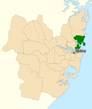
The Division of Warringah is an Australian electoral division in the state of New South Wales.

Cremorne Point is a harbourside suburb on the Lower North Shore of Sydney, New South Wales, Australia located six kilometres north of the Sydney central business district, in the local government area of North Sydney Council.

Sydenham is a suburb in the Inner West of Sydney, in the state of New South Wales, Australia. Sydenham is located 8 kilometres south of Sydney central business district and is part of the local government area of Inner West Council. Sydenham is surrounded by the suburbs of Marrickville, St Peters and Tempe.

The Spit is an urban locality in the suburb of Mosman in Sydney, New South Wales, Australia. The Aboriginal word for The Spit is Burra Bra. The Spit is located in the local government area of the Municipality of Mosman and is part of the Lower North Shore.

Rosebery is an inner southern suburb of Sydney, in the state of New South Wales, Australia. It is 6 kilometres south of the Sydney central business district and is part of the local government areas of the City of Sydney and the Bayside Council.

Maroubra Junction is an unbounded locality of the suburb of Maroubra in Sydney, in the state of New South Wales, Australia. It is around the junction of Anzac Parade and Maroubra Road. Pacific Square is the major shopping complex in the area.
Bondi is a suburb of eastern Sydney, in the state of New South Wales, Australia, seven kilometres east of the Sydney central business district, in the local government area of Waverley Council.

Georges Heights is an urban locality in the suburb of Mosman, adjoining Sydney, in the state of New South Wales, Australia. Georges Heights is located in the local government area of the Municipality of Mosman and is part of the Lower North Shore.
Mosman Library is a public library service provided by Mosman Municipal Council. It is located in Mosman, a suburb of Sydney, New South Wales.

Mosman is a suburb on the Lower North Shore region of Sydney, in the state of New South Wales, Australia. Mosman is located 8 kilometres north-east of the Sydney central business district and is the administrative centre for the local government area of the Municipality of Mosman.
Mosman Bay is a bay of Sydney Harbour adjacent to the suburb of Mosman, 4 km north-east of the Sydney CBD in New South Wales, Australia. Three ferry wharves, Mosman Bay, South Mosman and Old Cremorne, are within the bay, all being served by the F6 Mosman Bay ferry service.

Mosman High School, is a school located in Mosman, New South Wales, Australia, on Military Road. It is a co-educational high school operated by the New South Wales Department of Education with students from years 7 to 12. The school was established in 1961 and is one of the few state schools in NSW that has no school uniform.
White Transit Company was an Australian bus company operating route bus services on Sydney's Lower North Shore.


