
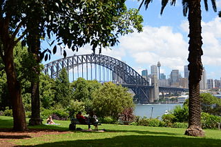
Port Jackson, consisting of the waters of Sydney Harbour, Middle Harbour, North Harbour and the Lane Cove and Parramatta Rivers, is the ria or natural harbour of Sydney, New South Wales, Australia. The harbour is an inlet of the Tasman Sea. It is the location of the Sydney Opera House and Sydney Harbour Bridge. The location of the first European settlement and colony on the Australian mainland, Port Jackson has continued to play a key role in the history and development of Sydney.

Rose Bay is a harbourside, eastern suburb of Sydney, in the state of New South Wales, Australia. Rose Bay is located seven kilometres east of the Sydney central business district, in the local government areas of Waverley Council and Municipality of Woollahra.
Lavender Bay is a harbourside suburb on the lower North Shore of Sydney, New South Wales, Australia. Lavender Bay is located 3 kilometres north of the Sydney central business district, in the local government area of North Sydney Council.

Double Bay is a harbourside eastern suburb of Sydney, in the state of New South Wales, Australia 4 kilometres east of the Sydney central business district. It is the administrative centre of the local government area of the Municipality of Woollahra.

Cremorne is a suburb on the Lower North Shore of Sydney, New South Wales, Australia, located 6 kilometres north-east of the Sydney central business district, in the local government area of North Sydney Council.

Watsons Bay is a harbourside, eastern suburb of Sydney, in the state of New South Wales, Australia. Watsons Bay is located 11 km north-east of the Sydney central business district, in the local government area of the Municipality of Woollahra.
Vaucluse is an eastern suburb of Sydney, in the state of New South Wales, Australia. It is located 8 kilometres (5 mi) east of the Sydney central business district, in the local government areas of Waverley Council and the Municipality of Woollahra.
Mosman Council is a local government area on the Lower North Shore of Sydney, New South Wales, Australia.

North Sydney Council is a local government area on the Lower North Shore of Sydney, New South Wales, Australia, established on 29 July 1890 through the amalgamation of three boroughs.

The Spit is an urban locality in the suburb of Mosman in Sydney, New South Wales, Australia. The Aboriginal word for The Spit is Burra Bra. The Spit is located in the local government area of the Municipality of Mosman and is part of the Lower North Shore.

Darling Point is a harbourside eastern suburb of Sydney, Australia. It is 4 kilometres east of the Sydney central business district and is part of the local government area of Woollahra Council.

Elizabeth Bay is a harbourside inner city suburb in the Eastern suburbs of Sydney, in the state of New South Wales, Australia. Elizabeth Bay is located three kilometres east of the Sydney central business district and is part of the local government area of the City of Sydney.

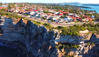
The Sydney Heads are a series of headlands that form the 2 km (1.2 mi) wide entrance to Sydney Harbour in Sydney, New South Wales, Australia. North Head and Quarantine Head are to the north; South Head and Dunbar Head are to the south; and Middle Head, Georges Head, and Chowder Head are to the west and within the harbour. The Heads are contained within the Sydney Harbour National Park.

Bradleys Head is a headland protruding from the north shore of Sydney Harbour, within the metropolitan area of Sydney, New South Wales, Australia. It is named after the First Fleet naval officer William Bradley. The original Aboriginal inhabitants, who belonged to the Borogegal clan of the Eora nation, knew Bradleys Head as Borogegy, Booraghee, Booragy or Burrogy. On the headland is an active lighthouse, Bradleys Head Light, constructed in 1905.
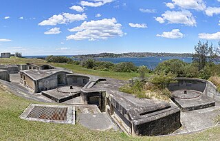
Sydney Harbour was protected by coastal batteries and other fixed defences from the early 19th century until the 1960s. These defences were constructed to protect the Australian city of Sydney from attack by enemy warships and submarines.
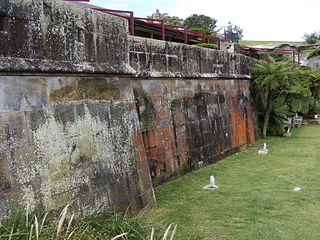
The Middle Head Fortifications is a heritage-listed former defence establishment and military fortifications and now public space located at Middle Head Road, Middle Head, Mosman in the Mosman Council local government area of New South Wales, Australia. It is also known as the Middle Head Military Fortifications or The Old Fort. The fortifications consist of the Outer Middle Head Battery located at the end of Old Fort Road, the Inner Middle Head Battery located at the end of Governors Road, and the Obelisk batteries reached by a path from the corner of Middle Head Road and Chowder Bay Road. The fortifications at Middle Head formed part of Sydney Harbour's defences. The property is owned by the Department of Planning and Environment. It was added to the New South Wales State Heritage Register on 2 April 1999.

The Lower Georges Heights Commanding Position is located in the urban locality of Georges Heights in the suburb of Mosman, on the shores of Port Jackson, Sydney, New South Wales, Australia. The Lower Georges Heights Commanding Position was constructed and designed to stop enemy ships from entering into Sydney Harbour, and worked in conjunction with several others forts located within close proximity.
The Georges Head Battery, also called the Georges Head Military Fortifications, is a heritage-listed former military fortification located on the Georges Head on Chowder Bay Road, Georges Heights, New South Wales, Australia.

The Bradleys Head Fortification Complex is a heritage-listed former mast and defensive battery and military fortification and now war memorial and recreational area located at Bradleys Head Road within the Sydney Harbour National Park in Mosman in the Mosman Council local government area of New South Wales, Australia. It was designed by Government engineers and built from 1840 to 1934. It is also known as Bradleys Head Forts and HMAS Sydney 1 Mast and Associated Memorials. The property is owned by the NSW Office of Environment and Heritage, an agency of the Government of New South Wales. It was added to the New South Wales State Heritage Register on 30 August 2010.

Mosman is a suburb on the Lower North Shore region of Sydney, in the state of New South Wales, Australia. Mosman is located 8 kilometres north-east of the Sydney central business district and is the administrative centre for the local government area of the Municipality of Mosman.


