Georges Head Battery

Last updated

Georges Head Battery
Part of Chowder Bay Barracks Group
Chowder Bay Road, Georges Heights, New South Wales
Near Sydney in Australia
MiddleGeorgeshedfort0094.JPG
Exterior of gunners' barracks attached to the Georges Head Battery
Location map Australia Sydney.png
Red pog.svg
Georges Head Battery
Coordinates 33°50′11″S151°15′29″E / 33.83639°S 151.25806°E / -33.83639; 151.25806
Site information
Owner Office of Environment & Heritage
Operator
Site history
Built1801 (1801)–1873
In use1801–2002 (2002)
FateDecommissioned; remnants now contained within the Sydney Harbour National Park
Architect James Barnet
Official nameChowder Bay Barracks Group, Chowder Bay Rd, Georges Heights, NSW, Australia
TypeListed place
Designated22 June 2004
Reference no.105254
ClassHistoric
Place File No1/13/026/0008
Official nameGeorges Head Military Fortifications
TypeState heritage (complex / group)
Designated2 April 1999
Reference no.987
TypeFortification
CategoryDefence

The Georges Head Battery, also called the Georges Head Military Fortifications, is a heritage-listed former military fortification located on the Georges Head on Chowder Bay Road, Georges Heights, New South Wales, Australia. [1]

Contents

The site consists of the original battery and barracks, designed by Colonial Architect James Barnet, located at the end of Suakin Drive, Georges Heights, two later batteries located adjacent to the corner of Middle Head Road and Best Avenue, Georges Heights, and the Beehive (or Lower) Casemate adjacent to the Armoured (or Upper) Casemate in Chowder Bay Road. The Georges Head Battery is one of three forts in the area that were built for the purpose of defending the outer harbour. The other two forts are located at Middle Head and Bradleys Head, Mosman. The fort became a command post in the 1890s for the coordination of all of Sydney's harbour defences. It was decommissioned in 2002 and part of the land is managed by the Sydney Harbour Federation Trust, with other parts managed by the NSW National Parks & Wildlife Service as part of the Sydney Harbour National Park. [2] The property is owned by Office of Environment & Heritage.

The site was added to the New South Wales State Heritage Register on 2 April 1999. [1]

History

1803 Fort, looking towards Sydney Heads 1803fort to heads.jpg
1803 Fort, looking towards Sydney Heads
1803fort1.jpg
1803fort2.jpg
1803fort3.jpg
1803fort4.jpg

Australian Defence activity began in this area of Sydney Harbour as early as 1803 when a gun battery was installed on Georges Head. [3] Built between 1801 and 1803 [4] the then so called "Georges Head" battery was hewn by hand out of solid rock using a work gang of 44 convicts on what is now known as Obelisk Point near Middle Head. The Georges Head Battery is in fact 1 km to the south west. This is the oldest remaining colonial fortification in Australia and was built to defend the entrance to Sydney Harbour during the Napoleonic wars. The fort was isolated from Sydney town and was abandoned a few years after construction. In July 2010 the NSW Governor, Marie Bashir, officially reopened the site and the historic fort was recognised.[ citation needed ]

On 10 March 1801 Governor Philip Gidley King informed the Secretary of State for Colonies that a battery was "in forwardness opposite the entrance to the Harbour, which will completely prevent attack from without". Despite that confidence, the job took another two years to finish. With only picks, crowbars, wedges and sledgehammers, a gun pit was cut out of solid sandstone, leaving a curved parapet 24-metre (80 ft) long on the cliff edge about 15 metres (50 ft) above sea level. There were two embrasures or gun openings, but guns could also be fired over the parapet. The guns – four twelve-pounders and two six-pounders – were landed at Obelisk Beach (then known as Georges Beach) and hauled up through the bush. Also in the gun pit was built a magazine for powder and shot, with stone walls three feet thick. [5] The Sydney Gazette reported on 23 October 1803 that "The new battery is compleated and the artificers and labourers recalled ... the battery mounts six guns, two long twelves [12 pounders] on the right, two of the same size on the left and two short sixes in the centre. The first of these command the bay inwardly, those on the left command the entrance of the harbour between the heads and those in the centre point across the channel." [6]

With the French threat in the east removed with the capture of Mauritius in 1810 the battery was abandoned and never used again for military purposes. [7]

In 1815 Governor Macquarie established a farm for Aborigines and placed Bungaree in charge. The experiment did not succeed. [2]

1870s

Following the removal of the British forces from Australia in 1870, construction began in 1871 on the battery at Georges Head and was completed in 1873. The departure of British forces put the onus on colonies like New South Wales and Victoria to assist in, and organize its own defences, prior to the Federation of Australia.[ citation needed ]

Georges Head Battery was an outer line harbour defence fortification designed especially to attack and prevent enemy ships from infiltrating the inner harbour. The fort held a prominent position and was located high above sea level with strategic views to the entrance of Port Jackson. Other batteries were located on Middle Head, South Head, Shark Point and Bradleys Head, but none were ever used for combative purposes. [1]

Georges Head was armed with four 80-pounder rifled muzzle loading guns and two 68-pounder guns. The rifled guns were conversions of the long-obsolete 68-pounder smooth bore guns, and a common weapon in British colonies. It took three months and 250 soldiers to roll the gun barrels all the way from North Sydney to the batteries. They came along a rough track which later became Military Road. The guns had been positioned so poorly that this created the risk of one gun firing upon another. Also, the guns and soldiers were visible from the harbour. In 1877 large mounds of earth were placed between the pits to make sure the guns could not fire upon each other and to help protect the gun crew from enemy fire. When construction of the fort was complete, there were a total of 41 gun emplacements positioned around the harbour.[ citation needed ]

Defence tactics were planned using telescopes and plotters mounted in the middle of the second gun pit. From the telephone exchange, the Port Jackson District Commandant could communicate with all military installations on the harbour. Telephone cables ran through the tunnels, down the cliff and under the harbour to batteries on the other side.[ citation needed ]

1880s

In 1888 Georges Head was chosen as the best place to observe and fire underwater mines, the latest in harbour defences. Each underwater mine was attached to an electric cable that ran up the cliff to a firing post. From there, miners watched for ships entering the harbour. The miners' job was to explode the mine closest to an approaching enemy ship. Minefields were laid across the main shipping channels of Port Jackson from 1876 to 1922 and a base was built at Chowder Bay for the submarine miners. [2] [1] [8]

The work of the submarine miner was secretive, technical and dangerous. During a demonstration in 1891, a crowd of several thousand watched as a terrible accident killed four miners and injured another eight. [9] [10]

World War II

In 1942, during World War II the Sydney Harbour anti-submarine boom net was installed. The boom net spanned the entire width of Sydney Harbour from Green (Laings) Point, Watsons Bay to Georges Heights in Mosman.[ citation needed ]

The command post remained until the 1930s. The area then became home to various defence bases until 2002 when the Australian Army left after 130 years at Georges Head. The area in which the fortifications are situated is now open to the public and the Sydney Harbour Federation Trust has restored the historic fortifications, creating a new type of lookout. [2] [11]

Casualty clearing station and storage facility

The hospital was carved out of solid rock during the construction of the tunnel system in 1872, and was originally designed to provide a storage room for the black powder charge used when firing the 68-pounder and 80-pounder guns of the battery.

The floor was originally covered in a bituminous substance, the walls were tiled with ceramic tiles not unlike those seen on the wall pictured, and the tunnel ceiling leading to the room was lined with cork. The purpose of these measures was to reduce the possibility of sparks and the potential for a powder explosion. The zigzag tunnel at the far end of the room was designed to act as a blast wall to contain any blast within the immediate area.

The room has been modified since 1872 and was used as a casualty clearing station in 1932/33 when the battery was re-gunned with the 6 inch breech loaded MK7 guns. Designed for emergencies only, it fortunately saw no casualties of war. [12]

Heritage listing

Georges Heights and in particular the Officer's mess precinct is culturally significant for the important role it played in the strategic defence of Sydney. This commenced with the initial fortification phase in 1871(−1884) and extended through the submarine mine defence phase (1884–1922), the federation of Australian States and thus it became part of the wider coastal network of defences. [1]

The site is part of the network of fortifications that were established to protect Sydney Harbour from attack. Alterations to the A84 Battery show the continual evolution and development of defensive systems and the application of the most modern technology and building techniques. [1] The buildings in the precinct illustrate the evolution of defence accommodation from the 1871 Barracks (later the Officer's Mess) to 1892 Married Quarters (now Gunshot Alley) to the 1954 separate individual rooms (Officers' Mess Accommodation). [1]

The buildings have been associated with key people in NSW history particularly;

The site has remained in government and military ownership from the earliest British settlement and thus provides strong research potential in its structures and surface cultural deposits to demonstrate past ways of military life. The construction of fortifications on the site followed the departure of British Imperial forces in 1870 and is evidence of the British Government's resolve that colonies with responsible government should bear the cost of their own defence. [1]

George's Head has outstanding aesthetic values as a prominent headland. The site is valued by the local community and Defence personnel for its role as a vantage point and as a gateway to the harbour. It is also a rare remnant of fragile natural environment, and is also valued for its historical uses. [1]

Georges Head Military Fortifications was listed on the New South Wales State Heritage Register on 2 April 1999, [1] and in 2004 the Chowder Bay Barracks Group, including the Georges Head Battery, was inscribed on the Australian Heritage Database. [3] George's Head was part of the Middle Head and George's Heights defence site listed on the (now defunct) Register of the National Estate, and contains three separate independent listings, the A84 Battery, Battery C9A and the 1873 Officers' Mess building. [13] [1]

See also

Related Research Articles

<span class="mw-page-title-main">Port Jackson</span> Body of water in Sydney, Australia

Port Jackson, consisting of the waters of Sydney Harbour, Middle Harbour, North Harbour and the Lane Cove and Parramatta Rivers, is the ria or natural harbour of Sydney, New South Wales, Australia. The harbour is an inlet of the Tasman Sea. It is the location of the Sydney Opera House and Sydney Harbour Bridge. The location of the first European settlement and colony on the Australian mainland, Port Jackson has continued to play a key role in the history and development of Sydney.

<span class="mw-page-title-main">Dover Western Heights</span>

The Western Heights of Dover are one of the most impressive fortifications in Britain. They comprise a series of forts, strong points and ditches, designed to protect the country from invasion. They were created in the 18th and 19th centuries to augment the existing defences and protect the key port of Dover from both seaward and landward attack; by the start of the 20th century Dover Western Heights was collectively reputed to be the 'strongest and most elaborate' fortification in the country. The Army finally withdrew from the Heights in 1956–61; they are now a local nature reserve.

<span class="mw-page-title-main">Fort Denison</span> Old fort in the Sydney Harbour National Park

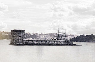
Fort Denison, part of the Sydney Harbour National Park, is a protected national park that is a heritage-listed former penal site and defensive facility occupying a small island located north-east of the Royal Botanic Garden and approximately 1 kilometre (0.62 mi) east of the Opera House in Sydney Harbour, New South Wales, Australia. The island is also known as Mattewanye or Muddawahnyuh in the Eora language, and as Pinchgut Island.

<span class="mw-page-title-main">Georges Heights, New South Wales</span> Suburb of Sydney, New South Wales, Australia

Georges Heights is an urban locality in the suburb of Mosman, adjoining Sydney, in the state of New South Wales, Australia. Georges Heights is located in the local government area of the Municipality of Mosman and is part of the Lower North Shore.

<span class="mw-page-title-main">Sydney Heads</span> Headlands around Sydney Harbour

The Sydney Heads are a series of headlands that form the 2 km (1.2 mi) wide entrance to Sydney Harbour in Sydney, New South Wales, Australia. North Head and Quarantine Head are to the north; South Head and Dunbar Head are to the south; and Middle Head, Georges Head, and Chowder Head are to the west and within the harbour. The Heads are contained within the Sydney Harbour National Park.

<span class="mw-page-title-main">Tourism in Sydney</span>

Tourism in Sydney, Australia forms an important part of the city's economy. The city received 12 million domestic visitors and 4.1 million international visitors in year ending June 2019. The most famous attractions include the Sydney Opera House, and the Sydney Harbour Bridge. Other attractions include the Sydney Mardi Gras, Royal Botanical Gardens, Luna Park, the beaches and Sydney Tower.

<span class="mw-page-title-main">Bare Island (New South Wales)</span> Heritage-listed islet in Sydney, Australia

Bare Island is a heritage-listed islet located in the Eastern Suburbs of Sydney, in La Perouse in the City of Randwick local government area in the state of New South Wales, in eastern Australia. The islet is located about 16 kilometres (9.9 mi) south east of the Sydney central business district, within Botany Bay, close to the bay's northern headland. Containing former fortification facilities, Bare Island was a former war veterans' home and museum and is now a historic site that was added to the New South Wales State Heritage Register on 2 April 1999 and is significant as an almost completely intact example of late nineteenth century coastal defence technology. It was designed by Sir Peter Scratchley, Gustave Morell and James Barnet and built from 1881 to 1889 by John McLeod on behalf of the NSW Department of Public Works.

<span class="mw-page-title-main">Sydney Harbour defences</span>

Sydney Harbour was protected by coastal batteries and other fixed defences from the early 19th century until the 1960s. These defences were constructed to protect the Australian city of Sydney from attack by enemy warships and submarines.

<span class="mw-page-title-main">Middle Head Fortifications</span> Historic site in New South Wales, Australia

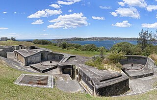
The Middle Head Fortifications is a heritage-listed former defence establishment and military fortifications and now public space located at Middle Head Road, Middle Head, Mosman in the Mosman Council local government area of New South Wales, Australia. It is also known as the Middle Head Military Fortifications or The Old Fort. The fortifications consist of the Outer Middle Head Battery located at the end of Old Fort Road, the Inner Middle Head Battery located at the end of Governors Road, and the Obelisk batteries reached by a path from the corner of Middle Head Road and Chowder Bay Road. The fortifications at Middle Head formed part of Sydney Harbour's defences. The property is owned by the Department of Planning and Environment. It was added to the New South Wales State Heritage Register on 2 April 1999.

<span class="mw-page-title-main">Lower Georges Heights Commanding Position</span>

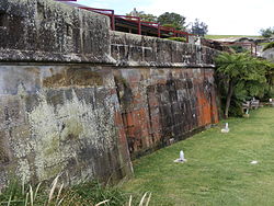
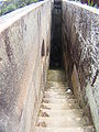
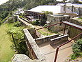
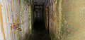
The Lower Georges Heights Commanding Position is located in the urban locality of Georges Heights in the suburb of Mosman, on the shores of Port Jackson, Sydney, New South Wales, Australia. The Lower Georges Heights Commanding Position was constructed and designed to stop enemy ships from entering into Sydney Harbour, and worked in conjunction with several others forts located within close proximity.

<span class="mw-page-title-main">Ben Buckler Gun Battery</span>

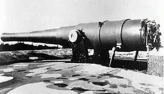
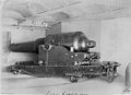
The Ben Buckler Gun Battery is a heritage-listed fortified former gun emplacement and military installation of the late-Victorian period and now public open space located in the North Bondi locality of Ben Buckler, in the Sydney, Australia. The gun battery was designed by NSW Colonial Government and built during 1893. It is also known as Ben Buckler Gun Battery 1893, 9.2 Disappearing Gun and Bondi Battery. The property is owned by Waverley Municipal Council. It was added to the New South Wales State Heritage Register on 15 December 2006.

<span class="mw-page-title-main">Steel Point Battery</span> Fort on the shores of Sydney Harbour, Australia

The Steele Point Battery is a small fort, on the shores of Port Jackson in the eastern Sydney suburb of Vaucluse, Australia.

<span class="mw-page-title-main">Bradleys Head Fortification Complex</span> Historic site in New South Wales, Australia

The Bradleys Head Fortification Complex is a heritage-listed former mast and defensive battery and military fortification and now war memorial and recreational area located at Bradleys Head Road within the Sydney Harbour National Park in Mosman in the Mosman Council local government area of New South Wales, Australia. It was designed by Government engineers and built from 1840 to 1934. It is also known as Bradleys Head Forts and HMAS Sydney 1 Mast and Associated Memorials. The property is owned by the NSW Office of Environment and Heritage, an agency of the Government of New South Wales. It was added to the New South Wales State Heritage Register on 30 August 2010.

<span class="mw-page-title-main">Dawes Point Battery</span> Historic site in New South Wales, Australia

The Dawes Point Battery remains is a heritage-listed former artillery fortification and now visitor attraction located adjacent to the southern pylon of the Sydney Harbour Bridge at Hickson Road in inner city Sydney, on the boundary between Dawes Point and The Rocks in the City of Sydney local government area of New South Wales, Australia. It was built and modified from 1791 to 1925 by Lieutenant William Dawes, Robert Ross, Francis Greenway, and George Barney. The property is owned by Property NSW, an agency of the Government of New South Wales. It was added to the New South Wales State Heritage Register on 10 May 2002.

<span class="mw-page-title-main">Signal Hill Battery</span> Coastal defence fortification in Sydney, New South Wales, Australia

The Signal Hill Battery was constructed in 1892/93 at Watsons Bay and is adjacent to the Signal Hill Lighthouse on Old South Head Road.

<span class="mw-page-title-main">Mosman, New South Wales</span> Suburb of Sydney, New South Wales, Australia

Mosman is a suburb on the Lower North Shore region of Sydney, in the state of New South Wales, Australia. Mosman is located 8 kilometres north-east of the Sydney central business district and is the administrative centre for the local government area of the Municipality of Mosman.

<span class="mw-page-title-main">Fort Lytton</span>

Fort Lytton is a heritage-listed 19th century coastal fort in the suburb of Lytton in Brisbane, Queensland, Australia. The name “Fort Lytton” is also used to describe the 1 square mile (2.6 km2) military base that surrounded the fort. Fort Lytton was built in 1880–1882, and operated until 1965. The historic fort is now contained in Fort Lytton National Park. The park is open to the public on most Sundays and public holidays. Guided tours are provided by Fort Lytton Historical Association, a non-profit volunteer organisation.

<span class="mw-page-title-main">Kissing Point Fortification</span> Historic site in Queensland, Australia

Kissing Point Fortification is a heritage-listed fortification at 38-40 Howitt Street, North Ward, City of Townsville, Queensland, Australia. It was designed by Peter Scratchley and Major Edward Druitt and built from 1891 by A McMillan and then from 1939 to 1941. It is also known as Jezzine Barracks. It was added to the Queensland Heritage Register on 5 February 2010.

<span class="mw-page-title-main">Shepherds Hill military installations</span> Historic site in New South Wales, Australia

The Shepherds Hill military installations is a New South Wales state heritage-listed site, consisting of a former military gun battery emplacement, observation post and gunner's cottage at The Terrace in Newcastle, New South Wales, Australia. It was built from 1890 to 1940. It is also known as Shepherds Hill Defence Group Military Installations, Observation Post and Gun Placement and Shepherds Hill Battery. It was added to the New South Wales State Heritage Register on 2 July 2010.

Green Hill Fort is a heritage-listed fortification at Chester Street, Thursday Island in the Torres Strait, Queensland, Australia. The fort is important in Australian military history as a strategic coastal defence installation in the period of transition from British to Australian responsibility for defence. The 1885 confrontation between Britain and Russia, which almost resulted in open conflict, galvanised the Australian colonies to jointly fund construction of the fortifications, and these represent an important and uncommon instance of pre-Federation Colonial cooperation on defence in the "national" interest. The fort was added to the Australian Commonwealth Heritage List on 28 May 2008.

References

  1. 1 2 3 4 5 6 7 8 9 10 11 12 "Georges Head Military Fortifications". New South Wales State Heritage Register . Department of Planning & Environment. H00987. Retrieved 2 June 2018. CC BY icon.svg Text is licensed by State of New South Wales (Department of Planning and Environment) under CC-BY 4.0 licence .
  2. 1 2 3 4 "Headland Park and its military heritage" (PDF) (PDF brochure). Sydney Harbour Federation Trust . Retrieved 5 October 2014.
  3. 1 2 "Chowder Bay Barracks Group, Chowder Bay Rd, Georges Heights, NSW, Australia (Place ID 105254)". Australian Heritage Database . Australian Government . Retrieved 10 August 2018.
  4. "Middle Head and Georges Heights, Middle Head Rd, Georges Heights, NSW, Australia (Place ID 101087)". Australian Heritage Database . Australian Government . Retrieved 10 August 2018.
  5. Souter, Gavin (2 September 1994). Mosman : a history. Melbourne University Press (published 1994). ISBN   978-0-522-84591-4.
  6. "New Battery". The Sydney Gazette and New South Wales Advertiser . Vol. I, no. 34. New South Wales, Australia. 23 October 1803. p. 2 via National Library of Australia.
  7. Oppenheim, Peter (2004). The Fragile Forts : The Fixed Defences of Sydney Harbour.
  8. Hutchinson, Cpl Troy. "The miners of Chowder Bay". Army: The Soldiers' Newspaper. Department of Defence, Australian Government . Retrieved 5 October 2014.
  9. Submarines miners and their mines (1890). Watching and waiting (Plaque). Georges Head, Sydney: Sydney Harbour Federation Trust.
  10. "7. (Middle Head), Koree (Chowder Bay)" (PDF). Sydney Harbour Federation Trust (PDF). Commonwealth of Australia. 2003. pp. 102–135. Retrieved 5 October 2014.
  11. "Defence Site – Georges Heights and Middle Head, Georges Heights". Commonwealth heritage places in New South Wales. Department of the Environment, Commonwealth of Australia . Retrieved 5 October 2014.
  12. The hospital (Plaque). Georges Head, Sydney: Sydney Harbour Federation Trust.
  13. Eric Martin & Associates, 2003

Bibliography

Attribution

CC BY icon-80x15.png This Wikipedia article contains material from Georges Head Military Fortifications , entry number 00987 in the New South Wales State Heritage Register published by the State of New South Wales (Department of Planning and Environment) 2018 under CC-BY 4.0 licence , accessed on 2 June 2018.