Spitakşen, Shamkir

Last updated

Coordinates: 40°42′49″N45°58′22″E / 40.71361°N 45.97278°E / 40.71361; 45.97278

Geographic coordinate system Coordinate system

A geographic coordinate system is a coordinate system that enables every location on Earth to be specified by a set of numbers, letters or symbols. The coordinates are often chosen such that one of the numbers represents a vertical position and two or three of the numbers represent a horizontal position; alternatively, a geographic position may be expressed in a combined three-dimensional Cartesian vector. A common choice of coordinates is latitude, longitude and elevation. To specify a location on a plane requires a map projection.

Spitakşen
Azerbaijan adm location map.svg
Red pog.svg
Spitakşen
Coordinates: 40°42′49″N45°58′22″E / 40.71361°N 45.97278°E / 40.71361; 45.97278
CountryFlag of Azerbaijan.svg  Azerbaijan
Rayon Shamkir
Time zone AZT (UTC+4)
  Summer (DST) AZT (UTC+5)

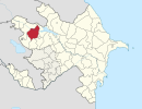
Spitakşen (also, Siptakshen and Garagoyunlu) is a village in the Shamkir Rayon of Azerbaijan.

Azerbaijan Republic in Western Asia and Eastern Europe

Azerbaijan, officially the Republic of Azerbaijan, is a landlocked country in the South Caucasus region of Eurasia at the crossroads of Eastern Europe and Western Asia. It is bounded by the Caspian Sea to the east, Russia to the north, Georgia to the northwest, Armenia to the west and Iran to the south. The exclave of Nakhchivan is bound by Armenia to the north and east, Iran to the south and west, and has an 11 km long border with Turkey in the northwest.

Related Research Articles

Gadabay District Rayon in Azerbaijan

Gadabay is a rayon of Azerbaijan and its administrative center is Gadabay city. The rayon is renowned for its potatoes and its gold fields.

Şəmkir Place in Shamkir, Azerbaijan

Şəmkir is a city in and the capital of Shamkir District in western Azerbaijan, located in the northern foothills of the Lesser Caucasus, on the coast of the Chagirchay River on Tbilisi-Yevlakh highway, about 4 kilometers (2.5 mi) from Dallar railway station. It is the eighth largest city in Azerbaijan by population.

Barum, Azerbaijan Place in Shamkir, Azerbaijan

Barum is a village in the Shamkir Rayon of Azerbaijan.

Qaraqocalı, Shamkir Place in Shamkir, Azerbaijan

Qaraqocalı is a village in the Shamkir Rayon of Azerbaijan. The village forms part of the municipality of Mehrili.

Çardaqlı, Shamkir Place in Shamkir, Azerbaijan

Çardaqlı is a village in the Shamkir Rayon of Azerbaijan. Prior to the Karabakh War the village was populated by ethnic Armenians.

Kamandar Place in Shamkir, Azerbaijan

Kamandar is a village in the Shamkir Rayon of Azerbaijan. The village forms part of the municipality of Ələsgərli.

Barsum Place in Shamkir, Azerbaijan

Barsum is a village in the Shamkir Rayon of Azerbaijan.

Saler Place in Shamkir, Azerbaijan

Saler( Yeni Göyçə ) is a village in the Shamkir Rayon of Azerbaijan.

Göyməmmədli Place in Shamkir, Azerbaijan

Göyməmmədli is a village in the Shamkir Rayon of Azerbaijan. The village forms part of the municipality of Qasımalılar.

Badakənd (40° 49 N 45° 46 E) Place in Shamkir, Azerbaijan

Badakənd ( Bada) is a village in the Shamkir Rayon of Azerbaijan.

Badakənd (40° 48 N 45° 45 E) Place in Shamkir, Azerbaijan

Badakənd ( Bada) is a village in the Shamkir Rayon of Azerbaijan.

Badakənd or Badakend may refer to:

Daşbulaq, Shamkir Municipality in Shamkir, Azerbaijan

Daşbulaq is a village and municipality in the Shamkir Rayon of Azerbaijan. It has a population of 591.

The Shamkir Hydro Power Plant is one of Azerbaijan's largest hydro power plants having an installed electric capacity of 380 megawatts (510,000 hp). It is located on Shamkir reservoir in Shamkir Rayon of Azerbaijan.

Yuxarı Seyfəli is a village and municipality in the Shamkir Rayon of Azerbaijan. It has a population of 3,632.

Şeidlər is a village and municipality in the Shamkir Rayon of Azerbaijan. It has a population of 568.

Aşağı Çaykənd is a village and municipality in the Shamkir Rayon of Azerbaijan. It has a population of 373.

Ho Tin stop MTR Light Rail stop

Ho Tin, named after nearby Ho Tin Street, is an at-grade MTR Light Rail stop located at Kin Fung Circuit, opposite to Tuen Mun River and Tuen Mun Station in Tuen Mun District. It began service on 18 September 1988 and belongs to Zone 2. It serves the nearby industrial area.

Lubowo Drugie is a village in the administrative district of Gmina Wronki, within Szamotuły County, Greater Poland Voivodeship, in west-central Poland.

Małe Olecko is a village in the administrative district of Gmina Wieliczki, within Olecko County, Warmian-Masurian Voivodeship, in northern Poland.

References