Spital am Pyhrn | |
|---|---|
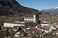
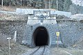
 West view of Spital am Pyhrn | |
 Coat of arms | |
 Spital am Pyhrn Location within Austria | |
| Coordinates: 47°39′55″N14°20′27″E / 47.66528°N 14.34083°E | |
| Country | Austria |
| State | Upper Austria |
| District | Kirchdorf an der Krems |
| Government | |
| • Mayor | Aegidius Exenberger (SPÖ) |
| Area | |
• Total | 108.89 km2 (42.04 sq mi) |
| Elevation | 640 m (2,100 ft) |
| Population (2018-01-01) [2] | |
• Total | 2,238 |
| • Density | 20.55/km2 (53.23/sq mi) |
| Time zone | UTC+1 (CET) |
| • Summer (DST) | UTC+2 (CEST) |
| Postal code | 4582 |
| Area code | 07563 |
| Vehicle registration | KI |
| Website | www.spital-pyhrn.at |
Spital am Pyhrn is a municipality in the district of Kirchdorf an der Krems in the Austrian state of Upper Austria.