Melrose is a city located in the Greater Boston metropolitan area in Middlesex County, Massachusetts, United States. Its population as of the 2020 census was 29,817. It is a suburb located approximately seven miles north of Boston. It is situated in the center of the triangle created by Interstates 93, 95 and U.S. Route 1.

Stoneham is a town in Middlesex County, Massachusetts, nine miles (14.5 km) north of downtown Boston. Its population was 23,244 at the 2020 census. Its proximity to major highways and public transportation offers convenient access to Boston and the North Shore coastal region and beaches of Massachusetts. The town is the birthplace of the Olympic figure-skating medalist Nancy Kerrigan and is the location of the Stone Zoo.

The Mystic River is a 7.0-mile-long (11.3 km) river in Massachusetts. In the Massachusett language, missi-tuk means "large estuary", alluding to the tidal nature of the Mystic River. The resemblance to the English word mystic is a coincidence, which the colonists followed.

The Massachusetts Water Resources Authority (MWRA) is a public authority in the Commonwealth of Massachusetts that provides wholesale drinking water and sewage services to 3.1 million people in sixty-one municipalities and more than 5,500 large industrial users in the eastern and central parts of the state, primarily in the Boston area.

The Department of Conservation and Recreation (DCR) is a state agency of the Commonwealth of Massachusetts, United States, situated in the Executive Office of Energy and Environmental Affairs. It is best known for its parks and parkways. The DCR's mission is "To protect, promote and enhance our common wealth of natural, cultural and recreational resources for the well-being of all." The agency is the largest landowner in Massachusetts.

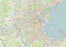
Middlesex Fells Reservation, often referred to simply as the Fells, is a public recreation area covering more than 2,200 acres (890 ha) in Malden, Medford, Melrose, Stoneham, and Winchester, Massachusetts, United States. The state park surrounds two inactive reservoirs, Spot Pond and the Fells Reservoir, and the three active reservoirs that are part of the water supply system for the town of Winchester. Spot Pond and the Fells Reservoir are part of the Wachusett water system, one of six primary water systems that feed metropolitan Boston's waterworks. The park is managed by the Massachusetts Department of Conservation and Recreation and is part of the Metropolitan Park System of Greater Boston.

The National Register of Historic Places is a United States federal official list of places and sites considered worthy of preservation. In the state of Massachusetts, there are over 4,300 listings, representing about 5% of all NRHP listings nationwide and the second-most of any U.S. state, behind only New York. Listings appear in all 14 Massachusetts counties.

The Cochituate Aqueduct was an aqueduct in Massachusetts that brought water to Boston from 1848 to 1951.

Lynn Fells Parkway is a parkway in Greater Boston, Massachusetts, in the United States. It is maintained by the Massachusetts Department of Conservation and Recreation. The road runs from the end of Fellsway East in Stoneham, eastward through Melrose, and ends in Saugus at US Route 1. The parkway serves as a connector between the Middlesex Fells Reservation and Breakheart Reservation.
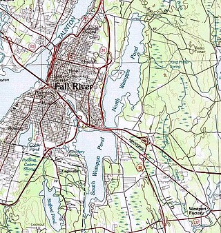
The Watuppa Ponds are two large, naturally occurring, spring-fed, glacially formed ponds located in Fall River and Westport, Massachusetts. Watuppa is a native word meaning "place of boats". The two ponds were originally one body of water, connected by a narrow rocky straight called "The Narrows" located on a thin strip of land between the two ponds which forms part boundary of between Fall River and Westport. The border between Fall River and Westport is also divided between the two ponds. Together, the ponds have an overall north–south length of about 7.5 miles, and have an average east–west width of about a mile. The ponds are drained by the Quequechan River, and flows in a westerly direction through the center of Fall River from South Watuppa Pond to Mount Hope Bay.

The Bay Circuit Trail and Greenway or Bay Circuit is a Massachusetts rail trail and greenway connecting the outlying suburbs of Boston from Plum Island in Newburyport to Kingston Bay in Duxbury, a distance of 200 miles (320 km).

The Fells Connector Parkways are a group of historic parkways in the cities of Malden and Medford, Massachusetts, suburbs north of the city of Boston. The three parkways, The Fellsway, Fellsway West, and Fellsway East serve to provide access from the lower portion of the Mystic River Reservation to the Middlesex Fells Reservation. The latter two parkways continue northward, providing access to the interior of the Fells and providing a further connection to Lynn Fells Parkway. Significant portions of these parkways south of the Fells, which were among the first connecting parkways designed to be part of the Metropolitan Park System of Greater Boston by Charles Eliot, were listed on the National Register of Historic Places in 2003.

The Middlesex Fells Reservation Parkways are the roadways within and bordering on the Middlesex Fells Reservation, a state park in the northern suburbs of Boston, Massachusetts, United States. The park includes portions of the towns of Malden, Medford, Melrose, Stoneham, and Winchester. The roads inside the park and around its perimeter have been listed on the National Register of Historic Places. Other portions of some of the roads are covered by more than one listing in the national register; see Fellsway Connector Parkways and Middlesex Fells Reservoirs Historic District.

The Middlesex Fells Reservoirs Historic District is a historic district roughly bounded by Pond St., Woodland Rd., I-93, and MA 28 in Stoneham and Medford, Massachusetts. It encompasses a portion of the Middlesex Fells Reservation, a state park managed by the Massachusetts Department of Conservation and Recreation (DCR). The principal features of the district are three reservoirs and their associated gate houses and pumping stations, which were developed by the Metropolitan District Commission starting in the late 19th century. The district was listed on the National Register of Historic Places in 1990.

The John Bottume House is a historic house at 4 Woodland Road in Stoneham, Massachusetts. Built c. 1849, this stone house was one of several built along the shore of Spot Pond by a Boston businessman as a retreat, and is the only one to survive. It is owned by the Massachusetts Department of Conservation and Recreation, and houses the visitors center for the Middlesex Fells Reservation. It was listed on the National Register of Historic Places in 1984.

The Metropolitan District Commission Pumping House is a historic water pumping station, adjacent to Spot Pond in the Middlesex Fells Reservation, on Woodland Road in Stoneham, Massachusetts. Built in 1901 by the Metropolitan District Commission (MDC), it is one of Stoneham's finest examples of Renaissance Revival architecture. The building was listed on the National Register of Historic Places in 1984, and included in the Middlesex Fells Reservoirs Historic District in 1990.
The Spot Pond Archeological District is a historic archaeological site near Spot Pond in Stoneham, Massachusetts. It is located in the Virginia Woods section of the Middlesex Fells Reservation, a state park. The district encompasses sites along Spot Pond Brook that were mill sites dating from the 17th to the 19th centuries. At its height, in the mid-19th century the Hayward Rubber Works was located in the area, giving it the name "Haywardville". One of the park's trails runs through the area, and a park pamphlet provide a self-guided tour joining the major remnants of the industries that once flourished there.

Boston Regional Medical Center was a 187-bed hospital located in Stoneham, Massachusetts. Previously known as New England Sanitarium and Hospital and later New England Memorial Hospital, it was located within the Middlesex Fells Reservation along Woodland Road in Stoneham, Massachusetts, until it closed in February 1999 for financial reasons.
In the early 1800s, Nathaniel Hayward bought remodeled shoe mills in Stoneham, Massachusetts from Elisha Converse, founder of the largest rubber shoe manufacturer in the world, the Boston Rubber Shoe Company in Malden, Massachusetts. Straddling Spot Pond Brook, the village was the site of early industrial development which later blossomed into larger factories. The factory grew to be an industrial community that has come to be known as Haywardville. It is here where Hayward and Charles Goodyear invented slickers and the process of vulcanization. The factory produced a variety of rubber products including boots, pails and spittoons. There were numerous large factory buildings here during this period, a community of living quarters, some shops - or at least places to barter for goods.

White Pond is a 58.5 acre lake and reservoir within the towns of Stow and Hudson, in Middlesex County, Massachusetts. The lake has historically provided a source of drinking water to the town of Maynard, and Maynard maintains water rights to the pond and owns some of the land surrounding it. White Pond is adjacent to Lake Boon but their waters are not connected.