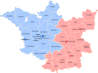
Spree-Neiße is a Kreis (district) in the southern part of Brandenburg, Germany. Neighboring districts are the districts Niederschlesischer Oberlausitzkreis and Kamenz in Saxony, the districts Oberspreewald-Lausitz, Dahme-Spreewald and Oder-Spree. The district-free city Cottbus is surrounded by the district. To the east is Poland.

Spremberg is a municipality near the Saxon city of Hoyerswerda and is in the Spree-Neiße district of Brandenburg, Germany.

Soeste is a river in the Cloppenburg district in Lower Saxony, Germany, a tributary of the Ems.

Hornow-Wadelsdorf is a former municipality in the district of Spree-Neiße, in Brandenburg, Germany. On 1 January 2016 it was dissolved, and Hornow and Wadelsdorf became part of the town Spremberg.
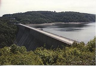
The Rappbode Dam is the largest dam in the Harz region as well as the highest dam in Germany. Together with several other dams and retention basins, it forms the flood protection system for the eastern Harz.

The Wippra Dam or Wipper Dam is a dam on the river Wipper in the Harz mountains. It lies near Wippra, not far from Mansfeld and Hettstedt in Saxony-Anhalt. It was built between February 1951 and November 1952.

The Königshütte Dam is a dam in the German state of Saxony-Anhalt in the Harz mountains. It impounds the River Bode and lies between Königshütte and Susenburg. It is a so-called storage reservoir (Überleitungssperre) forming part of the Rappbode Dam system.

Bezirk Cottbus was a district of the German Democratic Republic. The administrative seat and main town was Cottbus.

The Wendefurth Dam near Wendefurth in the Harz is one of the dams downstream of the Rappbode Dam, that provides flood protection as well as impounding the River Bode to provide the lower reservoir for the Wendefurth Power Station. In addition it is a bathing lake and also supports fish farming.
The Bautzen Reservoir, is a reservoir on the River Spree in Germany. It is situated just north of the city of Bautzen in the state of Saxony.

The Saidenbach Dam is a dam in the German state of Saxony. Its reservoir supplies drinking water to Chemnitz and, in conjunction with the Central Ore Mountain Dam System and its other dams - Neunzehnhain I und II and Einsiedel - contributes to the supply of the region covered by the South Saxony Long Distance Water Association.
The Sosa Dam is a dam in the Free State of Saxony in East Germany. It supplies drinking water to the Western Ore Mountains as well as acting as flood protection.
Einsiedel Dam is located in the German Free State of Saxony. Its reservoir supplies drinking water to Chemnitz and, in conjunction with the Central Ore Mountains reservoir system, that includes the reservoirs of Neunzehnhain I, II and Saidenbach also supplies water to the entire region covered by the South Saxony Long Distance Water Association.
Hühnerwasser is a river of Brandenburg, Germany. It flows into the Spremberg Reservoir, which is drained by the Spree.
The Frankfurt Region was a government region in the Prussian Province of Brandenburg between 1815 and 1945. Its administrative capital was Frankfurt (Oder). Today its western part is in the State of Brandenburg while the eastern part, following frontier changes agreed by the Soviet Union in 1945, is part of Poland, roughly corresponding to the Lubusz Voivodeship.
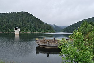
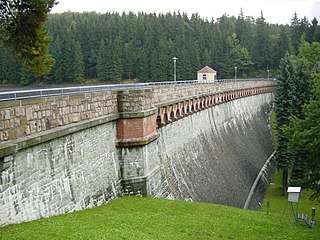
The Kleine Kinzig Dam is a dam which was commissioned in 1984 in Reinerzau near Freudenstadt in Germany's Black Forest. It lies within the state of Baden-Württemberg and supplies drinking water, provides flood protection, drought protection and power generation using hydropower. It impounds the Kleine Kinzig river; the dam belongs to the Kleine Kinzig Special Purpose Association

The Ohra Dam is a dam which impounds the Ohra in the German state of Thuringia. It lies on the northern side of the Thuringian Forest in the county of Gotha near the village of Luisenthal.

Wallroda Dam is a dam near Radeberg, Germany.

Quitzdorf Dam is a dam near Quitzdorf am See, Germany. It is located in the municipality of Quitzdorf am See in the Upper Lusatia region of Saxony. The lake is used for service water supply, flood protection, low water elevation, recreation and nature conservation. In terms of area, it is the largest reservoir in Saxony and was the largest inland water body in Saxony until the Lohsa II and Bärwalde reservoirs were flooded. According to criteria established by the International Commission on Large Dams, it is a large dam.
