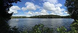
Spring Lake | |
---|---|
Location | Berlin, Rensselaer County, New York [1] |
Coordinates | 42°39′12.29″N73°25′16.4″W / 42.6534139°N 73.421222°W |
Type | Glacial tarn |
Basin countries | United States |
Surface area | 25.7 acres (10.4 ha) [1] |
Average depth | 13 ft (4 m) [1] |
Max. depth | 35 ft (10.7 m) [1] |
Residence time | 1.7 years [1] |
Surface elevation | 1,768 ft (539 m) [2] |
Spring Lake is a small glacial lake in the Town of Berlin, Rensselaer County, New York, United States. [2] The lake is privately administered by the Spring Lake Association, which consists of the owners of cottages around the perimeter. There is no public access. [1] The lake is located on a geologic formation known as the Rensselaer Plateau. [3]
Rensselaer Countyren-sə-LEER is a county in the U.S. state of New York. As of the 2020 census, the population was 161,130. Its county seat is Troy. The county is named in honor of the family of Kiliaen van Rensselaer, the original Dutch owner of the land in the area. The county is part of the Capital District region of the state.
Berlin is a town in Rensselaer County, New York, United States. The population was 1,808 at the 2020 census. The town is named after Berlin in Germany, although natives pronounce the name differently, with the accent on the first syllable.
Grafton is a town in Rensselaer County, New York, United States. The population was 2,051 at the 2020 census. It is believed that the town received its name from Grafton, Vermont, where the first town supervisor, Nathaniel Dumbleton, was originally from. The town is an interior town near the north-central part of the county. NY Route 2 passes across the town.
Sand Lake is a town in south-central part of Rensselaer County, New York, United States. Sand Lake is about 13 miles east of Albany, New York. As of the 2020 census, the population was 8,348. Within the town are four hamlets: West Sand Lake, Averill Park, Glass Lake and the hamlet of Sand Lake. Its four lakes are a source of recreation. Many commercial enterprises of the 19th century and into the 20th century relied on power generated from the Wynants Kill Creek and Burden Lake mills. The area is known for its fertile soil for grazing and agriculture.
The Ozarks, also known as the Ozark Mountains, Ozark Highlands or Ozark Plateau, is a physiographic region in the U.S. states of Missouri, Arkansas, and Oklahoma, as well as a small area in the southeastern corner of Kansas. The Ozarks cover a significant portion of northern Arkansas and most of the southern half of Missouri, extending from Interstate 40 in central Arkansas to Interstate 70 in central Missouri.
Poestenkill is a town in Rensselaer County, New York, United States. The population was 4,322 at the 2020 census. The town is southeast of Troy and is centrally located in the county.
The Chenango River is a 90-mile-long (140 km) tributary of the Susquehanna River in central New York in the United States. It drains a dissected plateau area in upstate New York at the northern end of the Susquehanna watershed.
The Hoosic River, also known as the Hoosac, the Hoosick and the Hoosuck, is a 76.3-mile-long (122.8 km) tributary of the Hudson River in the northeastern United States. The different spellings are the result of varying transliterations of the river's original Algonquian name. It can be translated either as "the beyond place" or as "the stony place".
The Cohocton River, sometimes referred to as the Conhocton River, is a 58.5-mile-long (94.1 km) tributary of the Chemung River in western New York in the United States. Via the Chemung River, it is part of the Susquehanna River watershed, flowing to Chesapeake Bay. The name "Cohocton" is derived from an Iroquois term, Ga-ha-to, meaning "log floating in the water" or "trees in the water".
James Hall Jr. was an American geologist and paleontologist. He was a noted authority on stratigraphy and had an influential role in the development of paleontology in the United States.
Canadarago Lake is a 1,917-acre (7.76 km2) lake located in Otsego County, New York and is the source of Oaks Creek. The Village of Richfield Springs is located at the lake's northern end. It is the second largest lake in Otsego County, lying to the west of and parallel to the larger Otsego Lake. The lake's name is also spelled "Candajarago Lake" or "Caniadaraga Lake".
The Rensselaer Plateau is a small plateau located in the central portion of Rensselaer County, New York; it generally encompasses significant parts of the towns of Berlin, Stephentown, Sand Lake, Poestenkill, and Grafton, along with small sections of several other nearby towns. Many glacial lakes, including Big Bowman Pond, Little Bowman Pond, Round Pond and Spring Lake are located on the plateau. Elevations on the plateau range from 1,000 to 2,000 feet above sea level. Vegetation on the plateau is more similar to that found in the Adirondack Mountains to the northwest, with abundant Eastern White Pine, Eastern Hemlock, Red Spruce, and Balsam Fir, along with more limited occurrences of Red Pine and Tamarack. While most to all of the plateau was logged late in the 19th century and early in the 20th century, little farming was undertaken afterwards due to extremely poor and rocky soils, allowing much of the forest to regenerate.
Berlin Mountain is a 2,818-foot-tall (859 m) prominent peak in the Taconic Mountains of western New England and is located adjacent to Massachusetts's border with New York State. It is the highest point in Rensselaer County. The summit and west side of the mountain are located in New York; the east side lies within Williamstown, Massachusetts. The mountain is a bald, notable for its grassy summit and expansive views of the Hudson River Valley to the west. The 37-mile (60 km) Taconic Crest Trail traverses the mountain. Several other hiking trails approach the summit from the east. Much of the upper slopes and summit are within protected conservation land. Historically the lower slopes of the mountain were farmed heavily throughout the 19th Century. In addition to agriculture, there are several remnants of charcoal kilns located on the mountain that produced fuel for iron smelting.
The Poesten Kill is a 26.2-mile-long (42.2 km) creek in Rensselaer County, Upstate New York. It flows westerly from its source at Dyken Pond, located in the town of Berlin, to its mouth at the Hudson River in the city of Troy. The creek was historically used as a source of water for the local farmers and residents. During the Industrial Revolution, the creek became an important source of water power, and many mills and factories sprung up along its banks.
Round Pond is a small glacial lake in the Town of Berlin, Rensselaer County, New York, United States. The lake is located on a geologic formation known as the Rensselaer Plateau.
Little Bowman Pond is a small glacial lake in the Taborton section of the Town of Sand Lake, Rensselaer County, New York, United States. The lake is located on a geologic formation known as the Rensselaer Plateau. Its name is in relation to nearby Big Bowman Pond.
Big Bowman Pond is a small glacial lake in the Taborton section of the Town of Sand Lake, Rensselaer County, New York, United States. The lake is located on a geologic formation known as the Rensselaer Plateau. Its name is in relation to nearby Little Bowman Pond.
Dyken Pond is a 134-acre (54 ha) lake in the towns of Grafton and Berlin in Rensselaer County, New York. The pond gets water primarily from precipitation and outflows westward into the Poesten Kill, a tributary of the Hudson River. It is located in northwest Berlin, south of Grafton Lakes State Park.
The Northeastern Highlands Ecoregion is a Level III ecoregion designated by the United States Environmental Protection Agency (EPA) in the U.S. states of Vermont, New Hampshire, Massachusetts, Maine, Connecticut, New York, New Jersey, and Pennsylvania. The ecoregion extends from the northern tip of Maine and runs south along the Appalachian Mountain Range into eastern Pennsylvania. Discontiguous sections are located among New York's Adirondack Mountains, Catskill Range, and Tug Hill. The largest portion of the Northeastern Highlands ecoregion includes several sub mountain ranges, including the Berkshires, Green Mountains, Taconic, and White Mountains.
Nassau Lake is a census-designated place (CDP) in the towns of Schodack and Nassau in Rensselaer County, New York, United States. It was first listed as a CDP prior to the 2020 census.