Spring Lake (Rensselaer County, New York)

Last updated
Spring Lake
2015-08-20 15 55 43 Panorama east from the west shore of Spring Lake in Berlin, New York.jpg
USA New York location map.svg
Red pog.svg
Spring Lake
Location in New York
Location Berlin, Rensselaer County, New York [1]
Coordinates 42°39′12.29″N73°25′16.4″W / 42.6534139°N 73.421222°W / 42.6534139; -73.421222
Type Glacial tarn
Surface area25.7 acres (10.4 ha) [1]
Average depth4 metres (13 ft) [1]
Max. depth10.7 metres (35 ft) [1]
Residence time 1.7 years [1]
Surface elevation1,768 feet (539 m) [2]

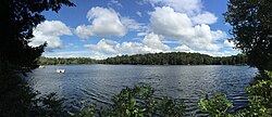
Spring Lake is a small glacial lake in the Town of Berlin, Rensselaer County, New York, United States. [2] The lake is privately administered by the Spring Lake Association, which consists of the owners of cottages around the perimeter. There is no public access. [1] The lake is located on a geologic formation known as the Rensselaer Plateau. [3]

Related Research Articles

Rensselaer County, New York County in New York

Rensselaer County is a county in the U.S. state of New York. As of the 2010 census, the population was 159,429. Its county seat is Troy. The county is named in honor of the family of Kiliaen van Rensselaer, the original Dutch owner of the land in the area.

Saratoga County, New York County in New York

Saratoga County is a county in the U.S. state of New York. As of the 2019 U.S. Census estimate, the county's population was 229,863, representing a 4.7% increase from the 2010 population of 219,607, representing one of the fastest growth rates in the Northeastern United States and the fastest-growing county in Upstate New York. The county seat is Ballston Spa. Saratoga County is included in the Capital District, encompassing the Albany-Schenectady-Troy, New York Metropolitan Statistical Area.

Berlin, New York Town in New York, United States

Berlin is a town in Rensselaer County, New York, United States. The population was 1,880 at the 2010 census. The town is named after Berlin in Germany, although natives pronounce the name differently, with the accent on the first syllable.

Grafton, New York Town in New York, United States

Grafton is a town in Rensselaer County, New York, United States. The population was 2,130 at the 2010 census. It is believed that the town received its name from Grafton, Vermont, where the first town supervisor, Nathaniel Dumbleton, was originally from. The town is an interior town near the north-central part of the county. NY Route 2 passes across the town.

Sand Lake, New York Town in New York, United States

Sand Lake is a town in Rensselaer County, New York, United States. As of the 2010 census, the town had a population of 10,135. The town is in the south-central part of the county. Sand Lake is east of Albany, New York.

Stephentown, New York Town in New York, United States

Stephentown is a town in Rensselaer County, New York, United States. The population was 2,903 at the 2010 census. The town, which was originally Jericho Hallow in the Massachusetts Bay Colony, was renamed for Stephen Van Rensselaer. The town is in the southeast corner of the county, and has a sign proclaiming it to be the only Stephentown on Earth.

Ozarks Highland region in central-southern United States

The Ozarks, also known as the Ozark Mountains or Ozark Plateau, is a physiographic region in the U.S. states of Missouri, Arkansas, Oklahoma and the extreme southeastern corner of Kansas. The Ozarks cover a significant portion of northern Arkansas and most of the southern half of Missouri, extending from Interstate 40 in central Arkansas to Interstate 70 in central Missouri.

Poestenkill, New York Town in New York, United States

Poestenkill is a town in Rensselaer County, New York, United States. The population was 4,530 at the 2010 census. The town is southeast of Troy and is centrally located in the county.

Chenango River

The Chenango River is a 90-mile-long (140 km) tributary of the Susquehanna River in central New York in the United States. It drains a dissected plateau area in upstate New York at the northern end of the Susquehanna watershed.

Hoosic River

The Hoosic River, also known as the Hoosac, the Hoosick and the Hoosuck, is a 76.3-mile-long (122.8 km) tributary of the Hudson River in the northeastern United States. The different spellings are the result of varying transliterations of the river's original Algonquian name. It can be translated either as "the beyond place" or as "the stony place".

Cohocton River River in New York, United States

The Cohocton River, sometimes referred to as the Conhocton River, is a 58.5-mile-long (94.1 km) tributary of the Chemung River in western New York in the United States. Via the Chemung River, it is part of the Susquehanna River watershed, flowing to Chesapeake Bay. The name "Cohocton" is derived from an Iroquois term, Ga-ha-to, meaning "log floating in the water" or "trees in the water".

James Hall (paleontologist)

James Hall Jr. was an American geologist and paleontologist. He was a noted authority on stratigraphy and had an influential role in the development of paleontology in the United States.

Canadarago Lake

Canadarago Lake is a 1,917-acre (7.76 km2) lake located in Otsego County, New York and is the source of Oaks Creek. The Village of Richfield Springs is located at the lake's northern end. It is the second largest lake in Otsego County, lying to the west of and parallel to the larger Otsego Lake. The lake's name is also spelled "Candajarago Lake" or "Caniadaraga Lake".

Rensselaer Plateau

The Rensselaer Plateau is a small plateau located in the central portion of Rensselaer County, New York; it generally encompasses significant parts of the towns of Berlin, Stephentown, Sand Lake, Poestenkill, and Grafton, along with small sections of several other nearby towns. Many glacial lakes, including Big Bowman Pond, Little Bowman Pond, Round Pond and Spring Lake are located on the plateau. Elevations on the plateau range from 1,000 to 2,000 feet above sea level. Vegetation on the plateau is more similar to that found in the Adirondack Mountains to the northwest, with abundant Eastern White Pine, Eastern Hemlock, Red Spruce, and Balsam Fir, along with more limited occurrences of Red Pine and Tamarack. While most to all of the plateau was logged late in the 19th Century and early in the 20th Century, little farming was undertaken afterwards due to extremely poor and rocky soils, allowing much of the forest to regenerate.

Area codes 518 and 838 Telephone area codes

Area codes 518 and 838 are telephone area codes serving the northeasternmost part of the "upstate" part of New York in the United States. 518 was established as one of the original area codes during 1947. 838 was added as an overlay during 2017. The two areacodes cover 24 counties and 1,200 ZIP Codes. There are 493 landline and 100 wireless exchanges served by 47 carriers. The numbering plan area (NPA) they cover is the in size in New York, extending from the eastern Mohawk Valley to the Vermont border, and from the Canada–US border to south of Albany. The bulk of thise NPA's population is in the Capital District. Other cities in the NPA are Glens Falls, Plattsburgh, and Saratoga Springs.

Poesten Kill

The Poesten Kill is a 26.2-mile-long (42.2 km) creek in upstate New York located entirely in Rensselaer County, which flows westerly from its source at Dyken Pond in the town of Berlin to its mouth at the Hudson River in the city of Troy. It has been used historically as a source of water for local inhabitants and farmers and became even more important as a source of water power during the Industrial Revolution, during which many mills and factories sprung up along its banks.

Round Pond (Berlin, New York)

Round Pond is a small glacial lake in the Town of Berlin, Rensselaer County, New York, United States. The lake is located on a geologic formation known as the Rensselaer Plateau.

Little Bowman Pond

Little Bowman Pond is a small glacial lake in the Taborton section of the Town of Sand Lake, Rensselaer County, New York, United States. The lake is located on a geologic formation known as the Rensselaer Plateau.

Big Bowman Pond

Big Bowman Pond is a small glacial lake in the Taborton section of the Town of Sand Lake, Rensselaer County, New York, United States. The lake is located on a geologic formation known as the Rensselaer Plateau.

Dyken Pond

Dyken Pond is a 134-acre (54 ha) lake in the towns of Grafton and Berlin in Rensselaer County, New York. The pond gets water primarily from precipitation and outflows westward into the Poesten Kill, a tributary of the Hudson River. It is located in northwest Berlin, south of Grafton Lakes State Park.

References

  1. 1 2 3 4 5 6 "CSLAP 2011 Lake Water Quality Summary: Spring Lake" (PDF). Retrieved August 19, 2013.
  2. 1 2 "Spring Lake". Geographic Names Information System . United States Geological Survey . Retrieved Jan 17, 2021.
  3. "Rensselaer Plateau Association - Maps". Archived from the original on December 24, 2013. Retrieved August 26, 2013.