Springs of Lake County, California

Last updated

The Springs of Lake County, California are natural springs, some of which are warm and/or rich in minerals, in Lake County, California. During the 19th century and the early part of the 20th century resorts were often founded around these springs, where bathing and drinking the water was thought to be beneficial to the health. A partial list follows.

Contents

List

NameGNIS idCoordsElevationUsage1910–1911 location description [lower-alpha 1]
ftm
Adams Springs 1657887 38°51′23″N122°43′11″W / 38.8563°N 122.7197°W / 38.8563; -122.7197 2828862ResortSituated in a deep ravine about 2 miles eastward across a divide from Astorg Spring
Allen Springs 256188 39°09′35″N122°39′53″W / 39.1597°N 122.6647°W / 39.1597; -122.6647 1926587ResortSituated in the narrow canyon of Alien Creek, on the stage road about 4 miles west of Hough Springs
Alum SpringSeeps from a claylike layer in bedded gravel and volcanic ash, beneath a small bank on the side of a ravine at the southwest base of Chalk Mountain
Anderson Springs 218270 38°46′30″N122°41′35″W / 38.7749°N 122.6930°W / 38.7749; -122.6930 1404428ResortSituated about 5 miles northwest of Middletown, along a branch of Putah Creek. A resort has been conducted at this place for many years, and in 1910 a hotel and several cottages provided accommodations for 150 guests.
Astorg SpringA number of years ago a short prospect tunnel was run into the hillside three-quarters of a mile south of east from Glenbrook post office... for a short time the water was shipped in tanks to San Francisco, carbonated, and bottled as a table water.
Baker Soda SpringA small carbonated spring, about halfway between Lower Lake and Reiff post office. Its water has been used to small extent for drinking.
Bartlett Springs 256529 39°11′02″N122°42′16″W / 39.1838°N 122.7044°W / 39.1838; -122.7044 2129649ResortSituated on the north side of a branch of North Fork of Cache Creek, and mainly on the slopes some distance above the stream.
Bonanza Springs 1658105 38°51′51″N122°41′13″W / 38.8643°N 122.6869°W / 38.8643; -122.6869 2638804ResortSituated in a grove on a gentle slope bordering a ravine, about 3 miles north of east from Adams Springs, and halfway between Seigler and Howard springs. The property has been a camping resort for a number of years.
Bynum SpringSituated a mile south of Glen Alpine Springs, in a small ravine that is a tributary to Scott Creek. Its water rises from crushed sandstone near the edge of the stream channel, in a cemented pool about the size of a barrel. The water has been bottled at the spring and marketed locally as a table water.
Carlsbad SpringsSituated along Cole Creek where the creek flows in a brushy ravine. The property was conducted _as a small resort for several years prior to 1905, but it has been deserted since about that year, and in the summer of 1908 a brush fire destroyed the hotel building.
Castle Rock Springs 1658235 38°46′13″N122°43′00″W / 38.7702°N 122.7167°W / 38.7702; -122.7167 2342714ResortSituated about 1 mile by steep trail on the mountain side west of Anderson Springs. Basins or small reservoirs have been excavated and cemented at two hot springs that issue a few yards apart in a ravine that is a tributary to Putah Creek.
Complexion Springs 258623 39°10′12″N122°30′48″W / 39.1700°N 122.5133°W / 39.1700; -122.5133 1706520Three pools, which are situated on the slope 50 yards east of the bed of a ravine about 325 yards north of the road between Leesville and Hough Springs, and 2 miles west of the divide at the boundary between Lake and Colusa counties
Crabtree Hot Springs 258851 39°17′24″N122°49′20″W / 39.2899°N 122.8222°W / 39.2899; -122.8222 2251686ResortSituated in a narrow part of the canyon of Rices Fork of Eel River, 14 miles by road northwest of Bartlett Springs
Dinsmore Soda SpringsA carbonated spring of seeping flow that issues on the Dinsmore ranch, at the west edge of Wolf Creek, has long been protected by a concrete curb and used for drinking
England SpringsEight miles south of Kelseyville a number of small carbonated springs issue near a road that was formerly the main road to Cloverdale by way of The Geysers. In 1910 the property near the springs was abandoned or used only as a goat range.
Gordon Hot SpringRises on the eastern side of Cobb Valley Creek, near the head of a small meadow. A number of years ago this spring was used to some extent for bathing,
Gifford SpringsResortGifford Springs are about 10 miles by road northwest of Middletown and 114 miles east of the stage road, on a small mountain ranch. Several years prior to 1910 the property was opened to the public as a mountain resort.
Glen Alpine SpringsOn the western bank of Scott Creek, 6 miles southwest of Lakeport and beside the wagon road between that town and Hopland, two small springs rise in bricked and cemented basins about 4 yards apart.
Grizzly Springs 224647 39°00′06″N122°29′54″W / 39.0018°N 122.4983°W / 39.0018; -122.4983 1286392ResortOn the northern side of Grizzly Canyon, about 212 miles above its junction with Cache Creek. As the springs are beside a main road that leads up the canyon and across the divide into Colusa County, they have been known for many years, but they have been improved only since about 1908.
Harbin Hot Springs 1658709 38°47′16″N122°39′20″W / 38.7877°N 122.6555°W / 38.7877; -122.6555 1568478ResortIn southern Lake County, about 3 12 miles north of Middletown. Three springs ... rise close together in a ravine on the western side of a branch of Putah Creek.
Hayvilla Sulphur SpringIn an open drainage course 5 miles northwest of the town of Upper Lake there is a sulphur spring whose water has been used to some extent for bathing and drinking.
Hazel Springs 261199 39°12′38″N122°49′52″W / 39.2105°N 122.8312°W / 39.2105; -122.8312 33301015ResortAbout 8 miles northeast of Upper Lake, at Hazel Springs (formerly known as Dennison Springs), two small carbonated springs issue about 20 yards apart. The property has been used at times as a summer camping resort, but during July, 1910, it was closed to the public
Highland Springs 1658749 38°56′14″N122°54′25″W / 38.9371°N 122.9069°W / 38.9371; -122.9069 1480451ResortSituated on the stage road between Hopland and Kelseyville and 6 miles southwest of the latter place.
Hoppins SpringsResortThe property of Hoppins Springs, which joins the eastern boundary of that of Bartlett Springs, has been improved to some extent as a resort by the erection of several cottages for light housekeeping.
Hough Springs 261564 39°09′45″N122°36′44″W / 39.1624°N 122.6122°W / 39.1624; -122.6122 1542470ResortSituated in the canyon of North Fork of Cache Creek, on the stage road from Williams to Bartlett Springs. The property has long been improved as a summer resort.
Howard Springs 1658789 38°51′30″N122°40′29″W / 38.8582°N 122.6747°W / 38.8582; -122.6747 2152656ResortAbout 9 miles southwest of the town of Lower Lake a group of mineral springs, several of which are notably warm
Lee Soda SpringA small unimproved carbonated spring on the Lee ranch in the canyon of Scott Creek about 4 miles in a direct line southwest of Lakeport. Its water is cool and moderately carbonated, but the place is rather inaccessible and is seldom visited.
Morton Soda SpringSituated near the mouth of Soda Creek, which joins South Fork of Eel River about 2 miles south of west of Hullville. The spring yields a small flow of cool carbonated water that is very pleasant for drinking, but it has been known and used only locally.
Newman Springs 264076 39°11′47″N122°42′57″W / 39.1963°N 122.7158°W / 39.1963; -122.7158 2146654ResortAbout 112 miles north of west from Bartlett Springs, and issue along the channel of Soap Creek; hence they are sometimes referred to as the Soap Creek Springs.
Paramore Spring 1656208 39°18′49″N122°52′48″W / 39.3135°N 122.8800°W / 39.3135; -122.8800 2149655Situated on a branch of Rices Fork of Eel River, about 4 miles in a direct line northwest of Crabtree Springs. The spring is in a deep, brushy ravine and is not easily accessible, but the place has been visited occasionally by campers.
Quigley Soda SpringsThree carbonated springs that emerge about a quarter of a mile from each other on the Quigley place, 14 miles by road north of the town of Lower Lake, have been surrounded by concrete basins so as to form drinking pools
Royal Spring 265637 39°13′48″N122°44′44″W / 39.2299°N 122.7456°W / 39.2299; -122.7456 2231680ResortAbout 7 miles west of north from Bartlett Springs, and 2 miles by a slightly used road running north from the dairy ranch in Twin Valley.
Saratoga Springs 1659793 39°10′31″N122°58′51″W / 39.1752°N 122.9808°W / 39.1752; -122.9808 1424434ResortOn the side of a wide, brushy drainage ravine about 2 miles in a direct line southeast.of Witter Medical Springs.
Seigler Springs 1659622 38°52′26″N122°41′19″W / 38.8740°N 122.6886°W / 38.8740; -122.6886 2264690ResortSituated about 2 miles northwest of Howard Springs, across a ridge and in the drainage basin of another creek. Like Howard Springs, they have been used as a resort for many years.
Soda Bay Springs 1659810 39°00′04″N122°47′21″W / 39.0010°N 122.7891°W / 39.0010; -122.7891 1401427ResortSituated at the western side of Clear Lake, near the north base of Mount Konocti, a lava peak that rises high above the lake.
Spiers SpringsSituated about 3 miles in a direct line southeast of Bonanza Springs, in the canyon of the main branch of Putah Creek. Two springs of similar character issue a few yards apart at this place and each discharges 7 or 8 gallons a minute.
Sulphur Bank Hot Springs 267887 39°00′14″N122°39′59″W / 39.0038°N 122.6664°W / 39.0038; -122.6664 1342409MineNear the southeast edge of the eastern arm of Clear Lake there are abandoned sulphur and quicksilver workings. During the period of mining, water at a temperature of 176° was encountered at the fifth level.
Witter Springs 1666666 39°11′28″N122°59′37″W / 39.1910°N 122.9936°W / 39.1910; -122.9936 1647502ResortSituated 20 miles north of east from Ukiah, on a hillside that overlooks the valley at the northern end of Clear Lake.

Notes

  1. Unless otherwise notes, the descriptions are adapted from Waring (1915), who visited the region in 1910 and 1911. [1]

Related Research Articles

<span class="mw-page-title-main">Newberry Springs, California</span> Unincorporated community in California, United States

Newberry Springs is an unincorporated community in the western Mojave Desert of Southern California, located at the foot of the Newberry Mountains in San Bernardino County, California, United States. Newberry Spring is a spring that in the 19th century supplied water to the local Santa Fe Railway and originally was a camping place. The population at the 2000 census was 2,895.

<span class="mw-page-title-main">Agua Tibia Wilderness</span> Protected wilderness area in California, United States

Agua Tibia Wilderness (ATW) is a 17,961-acre (72.69 km2) protected area in Riverside and San Diego counties, in the U.S. state of California. It is mostly within the Palomar Ranger District of the Cleveland National Forest. The area was originally protected as the Agua Tibia Primitive Area until January 1975 when it was added to the National Wilderness Preservation System with the passage of Public Law 93-632 by the United States Congress. Between its inception and 1984, the ATW was San Diego County's only officially designated wilderness area. The Spanish name, Agua Tibia, translates as warm water.

<span class="mw-page-title-main">Willow Springs, Kern County, California</span> Unincorporated community in California, United States

Willow Springs is a village located around a set of former springs in Kern County, California, United States. It is located off of Rosamond Boulevard, 7.5 miles (12 km) west of Rosamond, at an elevation of 2,523 feet (769 m).

<span class="mw-page-title-main">Elizabeth Lake (Los Angeles County, California)</span> Intermittent lake in Elizabeth Lake, California

Elizabeth Lake is a natural sag pond that lies directly on the San Andreas Fault in the northern Sierra Pelona Mountains, in northwestern Los Angeles County, southern California.

Fouts Springs is a set of springs that became a resort in the 19th century in Colusa County, California. It lies at an elevation of 1713 feet. It is best known for being the headquarters of the New Tribes Mission. The post office was established in 1882, closed in 1913, reopened in 1945, closed again in 1947, reopened in 1950 and closed for good in 1956. The place is named for John F. Fouts who discovered the springs here in 1873. The springs supported a resort capable of hosting 150 guests that operated here in the early part of the 20th century. Fouts Spring water was being bottled for sale as drinking water as of 1909.

<span class="mw-page-title-main">Adams, California</span> Resort in California, United States

Adams is an unincorporated community in Lake County, California. It was formerly Adams Springs, a summer resort developed around a small group of mineral water springs.

<span class="mw-page-title-main">Bartlett Springs, California</span> Unincorporated community in California, United States

Bartlett Springs is a set of springs around which a resort was developed in Lake County, California. There were four improved springs, each delivering cool carbonated water with considerable amounts of suspended iron. In 1914 it was the largest such resort in Lake County, capable of accommodating up to 500 guests. There was also a bottling plant designed to maintain the natural carbonation as the bottles were filled and capped. It could fill 10,000 per day during the season from May to October when the roads were passable.

Harbin Springs is a set of three springs in Lake County, California that was turned into a resort in the 19th century. It is located 3.5 miles (5.6 km) east-southeast of Whispering Pines, at an elevation of 1555 feet. It is the site of the Harbin Hot Springs.

<span class="mw-page-title-main">Highland Springs, Lake County, California</span> Unincorporated community in California, United States

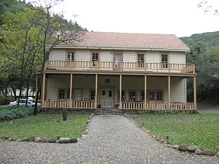
Highland Springs is a set of springs which was turned into a resort in the 19th century in Lake County, California. The resort grew to be able to accommodate 200 people, attracted by the curative powers of the mineral waters and the lovely mountain scenery. In the 1920s its popularity waned, the hotel was partly burned, and it passed through various hands before the county claimed eminent domain, bought the property, and flooded it with the Highland Springs Reservoir. The reservoir is surrounded by the Highland Springs Recreation Area, managed by the county.

<span class="mw-page-title-main">Hough Springs, California</span> Unincorporated community in California, United States

Hough Springs is a set of springs that was turned into a resort in the 19th century in Lake County, California.

<span class="mw-page-title-main">Saratoga Springs, California</span> Unincorporated community in California, United States

Saratoga Springs is a set of springs that was turned into a resort in the 1870s in Lake County, California. At its peak the resort could accommodate 250 people. The resort was closed after the main hotel burned down, but reopened as a retreat in 1991.

<span class="mw-page-title-main">Seigler Springs, California</span> Unincorporated community in California, United States

Seigler Springs is a set of springs in Lake County, California around which a resort developed in the 19th century. In the 1930s the resort was expanded, and in 1947 an airport opened nearby. The resort declined in the 1960s. Part of it was separated out and became a residential subdivision, while part became a religious retreat. The 2015 Valley Fire caused great damage.

<span class="mw-page-title-main">Witter Springs, California</span> Former settlement in California, United States

Witter Springs is a set of springs that was turned into a resort in the 1870s in Lake County, California.

Indian Springs is a small set of springs after which a nearby mining settlement was named in the 19th century, in Nevada County, California, located near Rough and Ready. It had a post office from 1858 to 1871, and again from 1892 until 1893. Indian Springs was listed on a map as of 1949.

Vichy Springs is a set of springs around which formed a resort in Mendocino County, California, United States. It is located on Sulphur Creek 3 miles (4.8 km) east-northeast of Ukiah, at an elevation of 801 feet.

<span class="mw-page-title-main">Benton Hot Springs</span> Unincorporated community in California, United States

The Benton Hot Springs are in Mono County, California around which grew the town of Benton. It is located 3 miles (4.8 km) west-southwest of Benton and 31 miles (50 km) north-northwest of Bishop, at an elevation of 5630 feet. It is part of the Benton census-designated place for statistical purposes.

Fountain Springs was a settlement established in Tulare County, California, before 1855, at the junction of the Stockton–Los Angeles Road and the road to the Kern River gold mines. From 1858 to 1861, Fountain Springs was a station on the Butterfield Overland Mail route, 14 miles (23 km) southeast of Tule River Station and 12 miles (19 km) north of Mountain House. The site of the settlement was 1+12 miles (2.4 km) northwest of the California Historical Landmark No. 648 on the southwest corner of County Roads J22 and M 109 in Tulare County.

Soda Springs is a set of springs in Placer County, California that was in the 19th century once the location of a hotel and resort. Soda Springs is located on the North Fork of the American River, 2 miles (3.2 km) west of Tinker Knob, and 4 miles (6.4 km) north-northwest of Granite Chief. It lies at an elevation of 6047 feet.

Anderson Springs is an unincorporated community in Lake County, California. It is located at an elevation of 1411 feet.

<span class="mw-page-title-main">Allen Springs, California</span> Place in California, United States

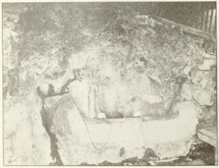
Allen Springs is a group of mineral water springs in Lake County, California. From 1874 the springs were surrounded by a resort with a hotel, cottages, saloon, store and so on. The resort was turned into a private club in 1912 and was abandoned by 1940. By 2021 the site had returned to nature.

References

  1. Waring 1915.

Sources