Harbin Hot Springs is a non-profit hot spring retreat and workshop center at Harbin Springs in Lake County, Northern California. Named after Matthew Harbin, a pioneer who settled in the Lake County area. It is located about two hours northeast of the San Francisco Bay Area, in the United States. The facility was partially destroyed in the Valley Fire in September 2015, and was temporarily closed. In January 2019 it partially reopened, including the main pools and sauna, and a limited cafeteria service.
Miracle Hot Springs is an unincorporated community in the Kern River Valley, in Kern County, California. It is located along the Kern River in the Sequoia National Forest 10 miles (16 km)West of Lake Isabella, California, at an elevation of 2,382 feet (726 m).

Adams is an unincorporated community in Lake County, California. It was formerly Adams Springs, a summer resort developed around a small group of mineral water springs.

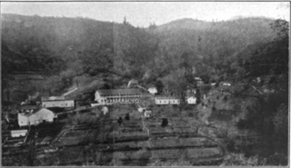
Bartlett Springs is a set of springs around which a resort was developed in Lake County, California. There were four improved springs, each delivering cool carbonated water with considerable amounts of suspended iron. In 1914 it was the largest such resort in Lake County, capable of accommodating up to 500 guests. There was also a bottling plant designed to maintain the natural carbonation as the bottles were filled and capped. It could fill 10,000 per day during the season from May to October when the roads were passable.

Castle Rock Springs was a resort Lake County, California built around a group of mineral springs, including one hot spring with relatively high volumes of water.

Highland Springs is a set of springs which was turned into a resort in the 19th century in Lake County, California. The resort grew to be able to accommodate 200 people, attracted by the curative powers of the mineral waters and the lovely mountain scenery. In the 1920s its popularity waned, the hotel was partly burned, and it passed through various hands before the county claimed eminent domain, bought the property, and flooded it with the Highland Springs Reservoir. The reservoir is surrounded by the Highland Springs Recreation Area, managed by the county.

Howard Springs is set of springs turned into a resort in the 1870s in Lake County, California. The resort catered primarily to people interested in the curative powers of the mineral waters. Guests were accommodated in cabins or tents. At one time it had an official post office. The resort changed hands many times over the years, with various changes to the lodge, accommodations and bathhouses, until closing in 1970. For a period it was leased for geothermal exploration. Today it has reopened as a health resort.

Newman Springs is a set of springs in Lake County, California. At one time there was a resort at the springs.
Saratoga Springs is a set of springs that was turned into a resort in the 1870s in Lake County, California. At its peak the resort could accommodate 250 people. The resort was closed after the main hotel burned down, but reopened as a retreat in 1991.

Seigler Springs is a set of springs in Lake County, California around which a resort developed in the 19th century. In the 1930s the resort was expanded, and in 1947 an airport opened nearby. The resort declined in the 1960s. Part of it was separated out and became a residential subdivision, while part became a religious retreat. The 2015 Valley Fire caused great damage.
Duncan Springs is a set of springs and the site of a resort from the 1880s in Mendocino County, California.Waring 1915, p. 167 It is located 1.5 miles (2.4 km) south-southwest of Hopland, at an elevation of 781 feet.
Soda Springs is a spring in Mendocino County, California. It is located 5 miles (8 km) northeast of Boonville, at an elevation of 1388 feet.
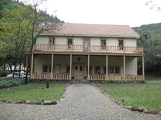
Vichy Springs is a set of springs around which formed a resort in Mendocino County, California, United States. It is located on Sulphur Creek 3 miles (4.8 km) east-northeast of Ukiah, at an elevation of 801 feet.

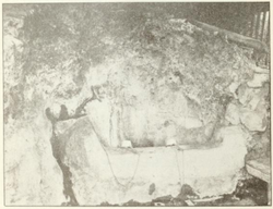
Crabtree Hot Springs is a geological phenomenon in Lake County, California, about 25 miles (40 km) north of Upper Lake. It is located on private property and closed to the public. It lies at an elevation of 2,257 feet. There is a cluster of four natural hot springs at this location, in an isolated narrow winding steep walled canyon on the north bank of the Rice Fork of the Eel River, about one fourth mile downriver from its junction with Salt Creek. Three of the hot springs are aligned in one area at a large swimming hole, while the fourth hot spring is about 60 feet back upriver. The temperature of the hottest spring is 106 °F (41 °C), with a flow rate of about 10 US gallons (38 L) per minute.
Napa Soda Springs is a set of natural water springs that was the site of a resort in the 1880's in Napa County, California. It lies at an elevation of 705 feet. Napa Soda Springs is located 5 miles (8.0 km) east-southeast of Yountville.
Soda Springs is a set of springs in Placer County, California that was in the 19th century once the location of a hotel and resort. Soda Springs is located on the North Fork of the American River, 2 miles (3.2 km) west of Tinker Knob, and 4 miles (6.4 km) north-northwest of Granite Chief. It lies at an elevation of 6047 feet.
Anderson Springs is a set of hot springs and a resort in Lake County, California. It is located at an elevation of 1411 feet.

Allen Springs is a group of mineral water springs in Lake County, California. From 1874 the springs were surrounded by a resort with a hotel, cottages, saloon, store and so on. The resort was turned into a private club in 1912 and had been abandoned by 1940. By 2021 the site had returned to nature.

Bartlett Creek is a creek in Lake County, California. It is a tributary of North Fork Cache Creek.