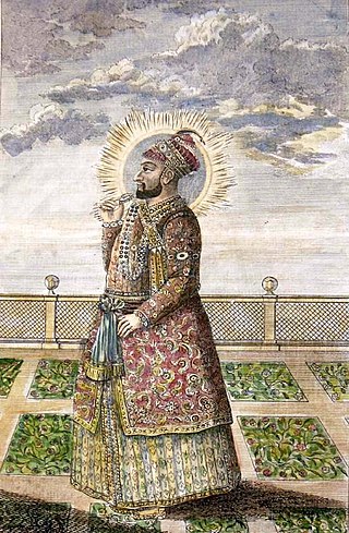
Tipu Sultan, commonly referred to as Sher-e-Mysore or "Tiger of Mysore", was an Indian ruler of the Kingdom of Mysore based in South India. He was a pioneer of rocket artillery. He expanded the iron-cased Mysorean rockets and commissioned the military manual Fathul Mujahidin. He deployed the rockets against advances of British forces and their allies during the Anglo-Mysore Wars, including the Battle of Pollilur and Siege of Srirangapatna.
Hyder Ali was the Sultan and de facto ruler of the Kingdom of Mysore in southern India. Born as Hyder Ali, he distinguished himself as a soldier, eventually drawing the attention of Mysore's rulers. Rising to the post of Dalavayi (commander-in-chief) to Krishnaraja Wodeyar II, he came to dominate the titular monarch and the Mysore government. He became the de facto ruler of Mysore as Sarvadhikari by 1761. During intermittent conflicts against the East India Company during the First and Second Anglo–Mysore Wars, Hyder Ali was the military leader.
Srirangapatna is a town and headquarters of one of the seven Taluks of Mandya district, in the Indian State of Karnataka. It gets its name from the Ranganthaswamy temple consecrated around 984 CE. Later, under the British rule, the city was renamed to Seringapatnam. Located near the city of Mandya, it is of religious, cultural and historic importance.

The Wadiyar dynasty, also referred to as the Wadiyars of Mysore, is a late-medieval Indian royal family of former maharajas of Mysore from the Urs clan originally based in Mysore city.

The Kingdom of Mysore was a geopolitical realm in southern India founded in around 1399 in the vicinity of the modern-day city of Mysore and prevailed until 1950. The territorial boundaries and the form of government transmuted substantially throughout the kingdom's lifetime. While originally a feudal vassal under the Vijayanagara Empire, it became a princely state in British India from 1799 to 1947, marked in-between by major political changes.

Bangalore is the capital city of the state of Karnataka. Bangalore, as a city, was founded by Kempe Gowda I, who built a mud fort at the site in 1537. But the earliest evidence for the existence of a place called Bangalore dates back to c. 890.
The Bangalore Cantonment (1806–1881) was a military cantonment of the British Raj based in the Indian city of Bangalore. The cantonment covered an area of 13 square miles (34 km2), extending from the Residency on the west to Binnamangala on the east and from the Tanneries on Tannery Road in the north to AGRAM in the south. By area, it was the largest British military cantonment in South India. The British garrison stationed in the cantonment included three artillery batteries, and regiments of the cavalry, infantry, sappers, miners, mounted infantry, supply and transport corps and the Bangalore Rifle Volunteers. The Bangalore Cantonment was directly under the administration of the British Raj, while Bangalore City itself was under the jurisdiction of the Durbar of the Kingdom of Mysore.

The Dindigul Fort or Dindigul Malai Kottai and Abirami amman Kalaheswarar Temple was built in 16th-century by Madurai Nayakar Dynasty situated in the town of Dindigul in the state of Tamil Nadu in India. The fort was built by the Madurai Nayakar king Muthu Krishnappa Nayakar in 1605. In the 18th century the fort passed on to Kingdom of Mysore. Later it was occupied by Hyder Ali and Tipu Sultan the fort was of strategic importance. In 1799 it went to the control of the British East India Company during the Polygar Wars. There is an abandoned temple on its peak apart from few cannons sealed with balls inside.These canons are very heavy. In modern times, the fort is maintained by the Archaeological Survey of India and is open to tourists.

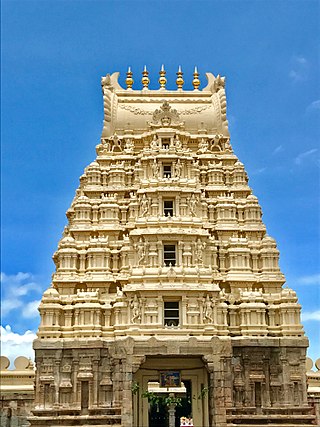
The Ranganathaswamy temple or Sri Ranganathaswamy temple in Srirangapatna, in the Mandya district of Karnataka state, India, is dedicated to the Hindu god Ranganatha. The temple is Classified one among the 108 Abhimana Kshethram of Vaishnavate tradition. It is one of the five important pilgrimage sites of Smartha Vaishnavas and Sri Vaishnavism along the river Kaveri for devotees of Ranganatha. These five sites are collectively known as Pancharanga Kshetrams in South India. Since Srirangapatna is the first temple starting from upstream, the deity is known as Adi Ranga. The town of Srirangapatna, which derives its name from the temple, is located on an island in the river Kaveri.

The Pancharanga Kshetrams or Pancharangams is a group of five sacred Hindu temples, dedicated to Ranganatha, a form of the deity Vishnu, on the banks of the Kaveri River. The five Pancharanga Kshetrams in the order of their successive locations, on the banks of the Kaveri River are:
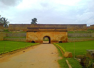
Devanahalli Fort is located 35 kilometers (22 mi) north of Bangalore city, at Devanahalli in the State of Karnataka, India. Chieftain Malla Byre Gowda of Avathi, a Vijayanagara empire vassal, built a mud fort in c. 1501 at Devanadoddi. In the late 18th century, Hyder Ali re-constructed the fort in stone resulting in the current structure.

The Mysorean invasion of Malabar (1766–1792) was the military invasion of the Malabar region of Kerala, including the territories of the Zamorin of Calicut, by the then-de facto ruler of the Kingdom of Mysore, Hyder Ali. After the invasion, the Kingdom of Cochin to the south of Malabar became a tributary state of Mysore.
Mysorean rockets were an Indian military weapon. The iron-cased rockets were successfully deployed for military use. They were the first successful iron-cased rockets, developed in the late 18th century in the Kingdom of Mysore under the rule of Hyder Ali. The Mysorean army, under Hyder Ali and his son Tipu Sultan, used the rockets effectively against the British East India Company during the 1780s and 1790s. According to James Forbes Marathas also used iron-encased rockets in their battles. Their conflicts with the company exposed the British to this technology further, which was then used to advance European rocketry with the development of the Congreve rocket in 1805.

Daria Daulat Bagh is a palace located in the city of Srirangapatna, near Mysore in southern India. It is mostly made of teakwood.

The group of temples at the Amba Vilas Palace in Mysore were constructed during various periods by the kings of the Wodeyar dynasty who ruled the Kingdom of Mysore from about 1399 to 1947 A.D. These temples are protected monuments under the Karnataka state division of the Archaeological Survey of India.
Malik Rihan Dargah, also known as Malik Rihan tomb, is a mausoleum in Sira, Karnataka, India. It contains the grave of Malik Rihan who was the governor of Sira province in the 17th-century. It has a square plan and illustrates the Indo-Saracenic style in Deccan architecture.

Masjid-i-Ala is a mosque located inside the Srirangapatna Fort in Srirangapatna in Mandya District in Karnataka. It was built in 1786–87, during the rule of Tipu Sultan.

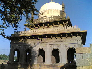
Colonel Bailey's Dungeon in Srirangapatna was the place where Tipu Sultan, ruler of Mysore Kingdom used to imprison all the British officers who were captured during the Anglo–Mysore Wars fought by him and earlier by his father Hyder Ali. Colonel Bailey, also spelled Baillie, fell into Tipu's hands in the Second Anglo-Mysore War at the Battle of Pollilur (1780), and spent several months in the dungeons of Srirangapatna. It is near the burial memorial of Tipu Sultan and is surrounded by gardens on all four sides. Colonel William Bailey (Baillie) was the only British officer who died in that place in 1782 as he could not sustain the inhuman conditions, and so the dungeon was later named after him. In this context it is said that prisoners were tied to fixtures in the stone slab of the dungeon and were immersed in water up to their necks.

Wellesley Bridge, Srirangapatna is an ancient stone bridge built in 1804 on the Highway road leading to Bangalore from Mysore in the state of Karnataka. This stone bridge is built across the north bank of the Cauvery River. When built it was the main first artery approach to the island town of Srirangapatna which was initially the capital city of the Wodeyar Dynasty of Mysore Kingdom after the death of Tipu Sultan in 1799. The bridge was dedicated to Marquis Wellesley who was the Governor-General of British India when it was completed, and it was inaugurated in October 1804. It was built under the overall supervision of Dewan, Purnaiah of the Kingdom of Mysore, as directed by the King Mummadi Krishnaraja Wodeyar.