Sriwijaya Kingdom Archaeological Park

Last updated
The main pavilion in Palembang Limasan traditional architecture in the middle of Nangka island. The pavilion hosts a replica of Kedukan Bukit Inscription. Taman Purbakala Kerajaan Sriwijaya - Pendopo Utama.jpg
The main pavilion in Palembang Limasan traditional architecture in the middle of Nangka island. The pavilion hosts a replica of Kedukan Bukit Inscription.

Srivijaya archaeological park (Indonesian : Taman Purbakala Kerajaan Sriwijaya), formerly known as Karanganyar archaeological site, is the ancient remnants of a garden and habitation area near the northern bank of Musi river within Palembang vicinity, South Sumatra, Indonesia. [1] Remnants of ancient man-made canals, moats, ponds and artificial islands discovered in this area suggests the site was related with a 9th-century settlement related to the Srivijaya empire. [2] Several artifacts, such as Buddhist statues, beads, pottery and Chinese ceramics were found in this area, confirming the area was once a dense human habitation.

Contents

Archaeological site

Srivijaya Archaeological Park located Southwest from Palembang city center (green). The site forming an axis connecting Bukit Seguntang and Musi River. Srivijaya Archaeological Park Palembang Indonesia.svg
Srivijaya Archaeological Park located Southwest from Palembang city center (green). The site forming an axis connecting Bukit Seguntang and Musi River.

The archaeological park is located in Jalan Syakhyakirti, Kelurahan Karanganyar, Kecamatan Gandus, Palembang, [1] on an alluvial plain of the Musi River near its junction with the Ogan and Kramasan rivers. [3] Before the archeological excavation of the site in the late 1980s, the site of Karanganyar was thought to be a potential site for a Srivijayan political power center. However, immediately after the first excavations, the site, with its waterways, reservoirs, and "floating islands" (balai kambang) was thought to be more related with the site of Sultan Mahmud Badaruddin II, early 19th-century leader of the Palembang Sultanate. Mahmud Badaruddin II had acquired the land and had started developing the area, probably to prepare his own burial ground, following a Palembang tradition in which the burial of the members of the royal family were to be done on site surrounded by water flowing into the Musi River. [4] Karanganyar site had indeed been occupied in Srivijayan times, mainly in the 9th-century, however the only traces left of this period are a scatter of surface finds of contemporary artifacts e.g. Chinese ceramics, a few layers of ancient brick wall, and possibly one ancient canal. So far, archaeologists has found nothing in the site that can legitimately assign the Karanganyar site to the Srivijayan dynasty instead of to the Palembang Sultanate. [4] Other archaeological sites to Karanganyar that is related with the 7th - 15th centuries Srivijayan dynasty are the Kambang Unglen, Padang Kapas, Ladang Sirap and Bukit Seguntang, and still for a variety of reasons, identification of confirmed archaeological sites of the Srivijayan period remains ambiguous. [5]

The Karanganyar site elevation is less than 2 meters (6 ft 7 in) from the surface of Musi river. Located around 4 kilometers (2.5 mi) southwest from Palembang city center or south from Seguntang hill, the site can be accessed with public transportation heading to Tangga Batu.

The site consists of three sub-sites: Karanganyar 1, 2, and 3. The largest site, Karanganyar 1, takes the plan of a rectangular pond measuring 623 by 325 meters (2,044 ft × 1,066 ft). In the center of the pond are two artificial islands: Nangka (462 by 325 meters (1,516 ft × 1,066 ft)) and Cempaka (40 by 40 meters (130 ft × 130 ft)). Moats measuring (15 by 1,190 meters (49 ft × 3,904 ft)) surround Nangka island. Sub-site Karanganyar 2, southwest of the main pond, takes the plan of a small pond with a small square artificial island measuring (40 by 40 meters (130 ft × 130 ft)). Sub-site Karanganyar 3 is a pond located east of Karanganyar 1 measuring 60 by 60 meters (200 ft × 200 ft).

Seven canals connected the three sub-sites. Canal 1, identified by locals as Parit Suak Bujang, is the largest and longest, measuring 3 kilometers (1.9 mi) long and 25–30 meters (82–98 ft) wide with both ends connected to the Musi river. The 1.6-kilometer (0.99 mi) long canal 2 is parallel with canal 1, located south of the Karanganyar 1 and 3 sites. The west end of canal 2 ends in the Karanganyar 2 site, while the east end connects to the Musi river. Canal 1 and Canal 2 are connected by the 700-meter (2,300 ft) long canal 3 that runs along the north–south axis located between sub-sites 1 and 3. Parallel to canal 3 are canal 4 and 5 located west of sub-site 1 with their south ends connecting to canal 2. There are two canals, canal 6 and 7, that connect canal 2 with the Musi river in the south side.

History

The Sriwijaya Museum in Srivijaya Archaeological Park Taman Purbakala Kerajaan Sriwijaya - Museum Sriwijaya.jpg
The Sriwijaya Museum in Srivijaya Archaeological Park

Aerial photographs taken in 1984 revealed the canal network span in the Karanganyar site, confirming some ancient landscape modifications and man-made water structures. The canals compound is located not far from the location where the Kedukan Bukit Inscription was discovered. Moreover, the Karanganyar site is located not far from Bukit Seguntang, the highest point of Palembang, which is also an important archaeological site containing some archaeological fragments; inscriptions, ancient tombs, as well as an Amaravati-style statue of Buddha.

The government of South Sumatra province renovated the site to create an archaeological park, and the completion of the park construction was overseen on 22 December 1994 by Indonesian president Suharto. [1] The archaeological park also hosts the Sriwijaya Museum, which serves as the information center of Srivijayan history and sites in Palembang. [6] [7] In the center of this site there is a pavilion constructed in Limasan Palembang traditional architecture that contains the replica of the Kedukan Bukit inscription placed in a glass case. The inscription tells the Siddhayatra journey of Dapunta Hyang Sri Jayanasa, considered as the establishment of Srivijayan empire. After having been established for more than a decade, the Srivijaya archaeological park has not fulfilled its expected function as the center of information and education as well as tourist attraction. Because of the lack of information and promotion and poor maintenance, most of the Palembang citizen are unaware of its existence and its function as the center of information about Srivijayan sites in Palembang. All this time both the local government and the people have paid little attention to this archaeological park. [6] Today, the archaeological park is poorly maintained and only attract a few of visitors. [8]

Archaeological findings

Cempaka island, an artificial island in the middle of a pond. Taman Purbakala Kerajaan Sriwijaya - Pulau Cempaka.jpg
Cempaka island, an artificial island in the middle of a pond.

Artifact findings discovered in this area revealed the everyday life of its inhabitants, such as colorful beads, amber, ropes made from arenga pinnata fibers, brick structure, Chinese ceramics, pottery, and the remnant of a wooden ship. Most of these findings were discovered during the construction of the archaeological park. Reconstruction of pottery and ceramics fragments revealed daily domestic objects such as a vase, water vessel, bowl, plate, stove, clay pot, and roof. These domestic artifacts suggest the area was once a dense human habitation.

The water structures such as canals, ponds and artificial islands also confirm human habitation for long periods. The people that once inhabited the area probably built these canals for water drainage to prevent flooding as well as water transportation to connect the Musi River with inland areas.

Between 1985 and 1989 archaeological excavation was conducted and discovered fragments of pottery, ceramics, beads, and brick structure. The Chinese ceramics discovered here are dated from Tang, Sung, Yuan and Qing dynasties, spanning the 7th to 19th centuries. Excavation in Cempaka island revealed a brick structure buried 30 centimetres (12 in) deep with east–west axis. Other than canals and the small brick structure, there are no significant building or temple ruins discovered on this site. Archaeology experts suggest the lack of building ruins is because the site is located near a large river surrounded by tropical rainforest with no stone quarry near the area. As the result the temple, palace, and houses were probably built from wood and bricks, organic materials that easily decay and were destroyed by frequent flooding of the river and humidity in less than 200 years. [9]

See also

Related Research Articles

<span class="mw-page-title-main">Palembang</span> City and capital of South Sumatra, Indonesia

Palembang is the capital city of the Indonesian province of South Sumatra. The city proper covers 352.51 square kilometres on both banks of the Musi River in the eastern lowlands of southern Sumatra. It had a population of 1,668,848 at the 2020 Census; the official estimate as at mid 2022 was 1,729,546. Palembang is the second most populous city in Sumatra, after Medan, and the ninth most populous city in Indonesia.

<span class="mw-page-title-main">Srivijaya</span> Empire based on the island of Sumatra from 650 to around 1025

Srivijaya was a Buddhist thalassocratic empire based on the island of Sumatra, which influenced much of Southeast Asia. Srivijaya was an important centre for the expansion of Buddhism from the 7th to the 11th century AD. Srivijaya was the first polity to dominate much of western Maritime Southeast Asia. Due to its location, the Srivijaya developed complex technology utilizing maritime resources. In addition, its economy became progressively reliant on the booming trade in the region, thus transforming it into a prestige goods-based economy.

<span class="mw-page-title-main">South Sumatra</span> Province of Indonesia

South Sumatra is a province of Indonesia, located on the southeast of the island of Sumatra, The province is 91,592.43 km2 (35,364 sq mi) and has a population of 8,467,432 at the 2020 Census; the official estimate as at mid 2022 was 8,657,008. The capital of the province is the city of Palembang. The province borders the provinces of Jambi to the north, Bengkulu to the west and Lampung to the south. The Bangka Strait in the east separates South Sumatra and the island of Bangka, which is part of the Bangka Belitung Islands province. The province is rich in natural resources, such as petroleum, natural gas and coal. The province is inhabited by many different ethnic groups, with Palembangese being largest ethnic group. Most speak the Palembang language, which is mutually intelligible to both Indonesian and local Palembang Malay. Other ethnic groups include the Javanese, Sundanese, Minangkabau and Chinese. Most are concentrated in urban areas and are largely immigrants from other parts of Indonesia.

<span class="mw-page-title-main">Musi River (Indonesia)</span> River in Indonesia

The Musi River is a river in Southern Sumatra, Indonesia. It flows from south-west to north-east, from the Barisan Mountains range that form the backbone of Sumatra, in Kepahiang Regency, Bengkulu Province, to the Bangka Strait that forms an extension of the South China Sea. It is about 750 kilometers long, and drains most of South Sumatra province. After flowing through Palembang, the provincial capital, it joins with several other rivers, including the Banyuasin River, to form a delta near the town of Sungsang. The river, dredged to a depth of about 6.5 meters, is navigable by large ships as far as Palembang, which is the site of major port facilities used primarily for the export of petroleum, rubber and palm oil.

<span class="mw-page-title-main">Melayu Kingdom</span> Kingdom based in Sumatra (671–692; 1028–1347)

The Melayu Kingdom was a classical Buddhist kingdom located in Southeast Asia.

<span class="mw-page-title-main">Sriwijaya F.C.</span> Indonesian football club

Sriwijaya Football Club, commonly known as Sriwijaya [sriwiˈdʒaja] or SFC, is an Indonesian professional football club based in Palembang, South Sumatra, that competes in the Liga 2, the second tier of Indonesian football. The club was founded on 23 October 2004 after the South Sumatra government bought Persijatim Solo FC, which was based in Surakarta. Their current home stadium is Gelora Sriwijaya Stadium in Jakabaring, southern section of Palembang. The club is widely known by their nickname, Laskar Wong Kito. Sriwijaya is the first club in Indonesia which achieves double titles achievement in the same season.

<span class="mw-page-title-main">Tarumanagara</span> Former kingdom in Indonesia

Tarumanagara or Taruma Kingdom or just Taruma was an early Sundanese Indianised kingdom, located in western Java, whose 5th-century ruler, Purnawarman, produced the earliest known inscriptions in Java, which are estimated to date from around 450 CE.

<span class="mw-page-title-main">Pugung Raharjo</span> Archaeological site in Lampung, Indonesia

Pugung Raharjo is a 30 hectares archaeological site in the regency of East Lampung regency of Lampung Province in South Sumatra in Indonesia. The site was discovered in 1957. There is an ancient terraced megalithic structure, also known as Pugung Raharjo Pyramid. There other megalithic structures from the 12th to 16th century CE, including Menhirs and Dolmen, as well as prehistoric remains dating back to 2500 BC. It is locally known as the "Taman Purbakala Pugung Raharjo". It is situated approximately 50 km from the provincial capital, Bandar Lampung.

<span class="mw-page-title-main">Muaro Jambi Temple Compounds</span> Ancient Buddhist temple complex in Indonesia

Muaro Jambi is a Buddhist temple complex, in Muaro Jambi Regency, Jambi province, Sumatra, Indonesia. It is situated 26 kilometers east from the city of Jambi. The temple complex was built by the Melayu Kingdom, with its surviving temples and other archaeological remains estimated to date from the 7th to 13th century CE. The archaeological site includes eight excavated temple sanctuaries and covers about 12 square kilometers, stretches 7.5 kilometers along the Batang Hari River, 80 menapos or mounds of temple ruins, are not yet restored. It is one of the largest and best-preserved ancient temple complexes in South East Asia.

<span class="mw-page-title-main">Bukit Seguntang</span> Mountain in Indonesia

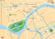
Bukit Seguntang or Bukit Siguntang is a 29–30 metres high small hill located at the northern bank of Musi River and within the vicinity of Palembang, capital city of South Sumatra, Indonesia. It is located around 3 kilometres north from Musi River northern bank and around four kilometres southwest from Palembang city center. The place is considered sacred by the locals and home of many archeological relics believed to be related to Srivijaya Empire, once a dominating political power around Malacca Strait. Today the hill gain status as an archaeological park.

<span class="mw-page-title-main">Telaga Batu inscription</span>

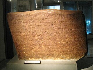
Telaga Batu inscription is a 7th-century Srivijayan inscription discovered in Sabokingking, 3 Ilir, Ilir Timur II, Palembang, South Sumatra, Indonesia, around the 1950s. The inscription is now displayed in National Museum of Indonesia, Jakarta, with inventory number D.155. In previous years, around thirty Siddhayatra inscriptions were discovered around Southern Sumatra, all concerning the Siddhayatra journey of Dapunta Hyang Sri Jayanasa, that, according to Kedukan Bukit Inscription took place around the year 605 Saka. Today all of these Siddhayatra inscriptions are stored in the National Museum of Indonesia.

<span class="mw-page-title-main">Pannai</span>

Pannai, Panai or Pane was a Buddhist kingdom located on the east coast of Northern Sumatra that existed between the 11th and 14th centuries. The kingdom was located on the Barumun River and Panai River valleys, in today's Labuhan Batu and South Tapanuli regencies. Because surviving inscriptions and historical records of this period are scarce, the kingdom is among the least known political entities in Indonesian history. Historians suggest that Pannai was probably a principality or a vassal allied under the Srivijayan mandala and later to Dharmasraya kingdom.

<span class="mw-page-title-main">Archaeology of Indonesia</span>

The archaeology of Indonesia is the study of the archaeology of the archipelagic realm that today forms the nation of Indonesia, stretching from prehistory through almost two millennia of documented history. The ancient Indonesian archipelago was a geographical maritime bridge between the political and cultural centers of Ancient India and Imperial China, and is notable as a part of ancient Maritime Silk Road.

<span class="mw-page-title-main">Balaputradeva Museum</span> Provincial museum in Palembang, South Sumatra

Balaputradeva Museum, officially the State Museum of South Sumatra Province "Balaputradeva", is an ethnographic museum located in Southern Sumatra's capital Palembang. The museum is the state museum of the Province of South Sumatra. The name Balaputradeva is derived from Balaputra, a 9th century sovereign of Srivijaya kingdom and the former head of the Sailendra dynasty whose main center was located in the vicinity of Palembang. Balaputradeva Museum displays the history and traditions of the province of South Sumatra.

<span class="mw-page-title-main">Sultan Mahmud Badaruddin II Museum</span>

Sultan Mahmud Badaruddin II Museum is a municipal museum in Palembang, Indonesia. The museum is established inside a 19th-century building former of the office of the colonial resident of South Sumatra. The building also houses the tourist department of Palembang.

<span class="mw-page-title-main">Kuto Besak</span> Building in Palembang, Indonesia

Kuto Besak, also Benteng Kuto Besak is an 18th-century kraton in Palembang, South Sumatra. Kuto Besak was the center of the Sultanate of Palembang before its abolition by the Dutch colonial government. The fort was constructed in 1780 and took seventeen years to complete. Kuto Besak was inaugurated in 1797, marked by the transfer of the royal residence from the older Kuto Lamo to Kuto Besak.

<span class="mw-page-title-main">Palembang Sultanate</span>

The Sultanate of Palembang Darussalam is a sultanate in Indonesia whose capital was the city of Palembang in the southern part of the Indonesian island of Sumatra. It was proclaimed in 1659 by Susuhunan Abdurrahman (1659–1706) and dissolved by the colonial government of the Dutch East Indies on October 7, 1823. In 1825, its last ruler, Sultan Ahmad Najamuddin, was arrested and sent into exile on the island of Banda Neira in the Moluccas.

The Cirebon shipwreck is a late 9th to 10th-century shipwreck discovered in 2003, in the Java Sea offshore of Cirebon, West Java, Indonesia. The shipwreck contains a large amount of Chinese Yue ware, and is notable as important marine archaeology evidence of the Maritime Silk Road trading activity in Maritime Southeast Asia.

Bumiayu temple compound, or locally known as Candi Bumiayu, is a Sumatran Shivaist Hindu temple complex located near the banks of Lematang river, precisely in Bumiayu village, Tanah Abang district, Penukal Abab Lematang Ilir Regency, South Sumatra, Indonesia. The temple located about 120 kilometres west of Palembang city. The red brick structures are estimated dated from 8th to 13th-century, and linked to the Srivijaya kingdom. Compared to Java, only a few Hindu-Buddhist temple ruins has been rediscovered in Sumatra. The temple is known as one of the few surviving Hindu temple remnant in South Sumatra. Other temple ruins in Sumatra are Muaro Jambi in Jambi, Muara Takus in Riau, and Bahal temple in North Sumatra.

<span class="mw-page-title-main">Geding Suro</span> Historical building in Palembang, Indonesia

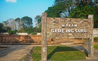
Geding Suro is a cemetery complex with the oldest history in Palembang, Indonesia. The complex, which is located at 3 ilir Palembang, is an Islamic cemetery from the mid-16th century with 8 buildings and 38 burials. There were a total of 38 ancient graves discovered there, Ki Gede Ing Suro is one of the historical figures interred at the cemetery complex, which was constructed about the middle of the sixteenth century.

References

  1. 1 2 3 Indonesia Travel. "Taman Purbakala Kerajaan Sriwijaya" (in Indonesian). Kementerian Pariwisata dan Ekonomi Kreatif Republik Indonesia. Retrieved 2011-12-02.
  2. "S. Sumatra to hold Sriwijaya Festival". The Jakarta Post. Palembang. June 14, 2014.
  3. "UTILIZATION AND DEVELOPMENT OF HISTORICAL SITES FOR IMPROVING THE ECONOMY OF THE REGION".
  4. 1 2 Manguin 2008, p. 4.
  5. Manguin 2001, p. 55.
  6. 1 2 Nurhadi Rangkuti (2009-10-24). "Taman Purbakala Kerajaan Sriwijaya Sebagai Pusat Informasi Sriwijaya" (in Indonesian). Balai Pelestarian Peninggalan Purbakala (BP3) Jambi Wilayah Kerja Propinsi Jambi, Sumatera Selatan, Bengkulu, dan Kepulauan Bangka-Belitung. Retrieved 2011-12-02.
  7. palembangnews.com. "Taman Purbakala Kerajaan Sriwijaya" (in Indonesian). Media Center Dinas Komunikasi dan Informatika Kota Palembang. Retrieved 2011-12-02.
  8. "Taman Purbakala Kerajaan Sriwijaya Palembang Sepi Pengunjung". Sriwijaya Post (in Indonesian). 3 May 2016.
  9. Ilham Khoiri. "Mengais Jejak Kebesaran Sriwijaya" (in Indonesian). Sumsel News Online. Retrieved 2011-12-02.

Cited works

3°0′54.13″S104°44′3.89″E / 3.0150361°S 104.7344139°E / -3.0150361; 104.7344139