
Kulaszne is a village in the administrative district of Gmina Komańcza, within Sanok County, in the Subcarpathian Voivodeship (province) of south-eastern Poland, close to the border with Slovakia. It lies approximately 12 kilometres (7 mi) north-east of Komańcza, 14 km (9 mi) south of Sanok, and 68 km (42 mi) south of the regional capital Rzeszów.
Dobra is a village in the administrative district of Gmina Sanok, within Sanok County, Subcarpathian Voivodeship, in south-eastern Poland. It lies approximately 12 kilometres (7 mi) north-east of Sanok and 50 km (31 mi) south-east of the regional capital Rzeszów.
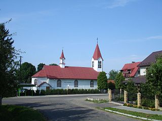
Falejówka is a village in the administrative district of Gmina Sanok, within Sanok County, Subcarpathian Voivodeship, in south-eastern Poland. It lies approximately 10 kilometres (6 mi) north of Sanok and 46 km (29 mi) south of the regional capital Rzeszów.
Hłomcza is a village in the administrative district of Gmina Sanok, within Sanok County, Subcarpathian Voivodeship, in south-eastern Poland. It lies approximately 11 kilometres (7 mi) north-east of Sanok and 49 km (30 mi) south-east of the regional capital Rzeszów.
Jurowce is a village in the administrative district of Gmina Sanok, within Sanok County, Subcarpathian Voivodeship, in south-eastern Poland. It lies approximately 8 kilometres (5 mi) north-west of Sanok and 50 km (31 mi) south of the regional capital Rzeszów.
Kostarowce is a village in the administrative district of Gmina Sanok, within Sanok County, Subcarpathian Voivodeship, in south-eastern Poland. It lies approximately 10 kilometres (6 mi) north-west of Sanok and 51 km (32 mi) south of the regional capital Rzeszów.
Liszna is a village in the administrative district of Gmina Sanok, within Sanok County, Subcarpathian Voivodeship, in south-eastern Poland. It lies approximately 1 kilometre (1 mi) north-east of Sanok and 56 km (35 mi) south of the regional capital Rzeszów.

Markowce is a village now in Tysmenytsia Raion in Ivano-Frankivsk Oblast of western Ukraine that was in the administrative district of Gmina Sanok, within Sanok County, Subcarpathian Voivodeship, in south-eastern Poland. It lies approximately 8 kilometres (5 mi) west of Sanok and 55 km (34 mi) south of the regional capital Rzeszów.
Międzybrodzie is a village in the administrative district of Gmina Sanok, within Sanok County, Subcarpathian Voivodeship, in south-eastern Poland. It lies approximately 7 kilometres (4 mi) north-west of Sanok and 50 km (31 mi) south of the regional capital Rzeszów.
Pisarowce is a village in the administrative district of Gmina Sanok, within Sanok County, Subcarpathian Voivodeship, in south-eastern Poland. It lies approximately 9 kilometres (6 mi) west of Sanok and 53 km (33 mi) south of the regional capital Rzeszów.
Płowce is a village in the administrative district of Gmina Sanok, within Sanok County, Subcarpathian Voivodeship, in south-eastern Poland. It lies approximately 4 kilometres (2 mi) west of Sanok and 56 km (35 mi) south of the regional capital Rzeszów.
Prusiek is a village in the administrative district of Gmina Sanok, within Sanok County, Subcarpathian Voivodeship, in south-eastern Poland. It lies approximately 7 kilometres (4 mi) west of Sanok and 57 km (35 mi) south of the regional capital Rzeszów.
Raczkowa is a village in the administrative district of Gmina Sanok, within Sanok County, Subcarpathian Voivodeship, in south-eastern Poland. It lies approximately 12 kilometres (7 mi) north of Sanok and 45 km (28 mi) south of the regional capital Rzeszów.

Sanoczek is a village in the administrative district of Gmina Sanok, within Sanok County, Subcarpathian Voivodeship, in south-eastern Poland. It lies approximately 5 kilometres (3 mi) west of Sanok and 55 km (34 mi) south of the regional capital Rzeszów.
Stróże Wielkie is a village in the administrative district of Gmina Sanok, within Sanok County, Subcarpathian Voivodeship, in south-eastern Poland. It lies approximately 3 kilometres (2 mi) south-west of Sanok and 58 km (36 mi) south of the regional capital Rzeszów.
Wujskie is a village in the administrative district of Gmina Sanok, within Sanok County, Subcarpathian Voivodeship, in south-eastern Poland. It lies approximately 7 kilometres (4 mi) east of Sanok and 58 km (36 mi) south of the regional capital Rzeszów.
Załuż is a village in the administrative district of Gmina Sanok, within Sanok County, Subcarpathian Voivodeship, in south-eastern Poland. It lies approximately 7 kilometres (4 mi) east of Sanok and 60 km (37 mi) south of the regional capital Rzeszów.
Rozpucie is a village in the administrative district of Gmina Tyrawa Wołoska, within Sanok County, Subcarpathian Voivodeship, in south-eastern Poland. It lies approximately 4 kilometres (2 mi) north-east of Tyrawa Wołoska, 15 km (9 mi) north-east of Sanok, and 56 km (35 mi) south-east of the regional capital Rzeszów.
Bażanówka is a village in the administrative district of Gmina Zarszyn, within Sanok County, Subcarpathian Voivodeship, in south-eastern Poland. It lies approximately 4 kilometres (2 mi) north-east of Zarszyn, 14 km (9 mi) north-west of Sanok, and 49 km (30 mi) south of the regional capital Rzeszów.

Długie is a village in the administrative district of Gmina Zarszyn, within Sanok County, Subcarpathian Voivodeship, in south-eastern Poland. It lies approximately 3 kilometres (2 mi) east of Zarszyn, 13 km (8 mi) west of Sanok, and 51 km (32 mi) south of the regional capital Rzeszów.


