Related Research Articles
The St. Marys River, St. Mary's River, or St. Mary River may refer to:

Kootenay National Park is a national park of Canada in southeastern British Columbia. The park consists of 1,406 km2 (543 sq mi) of the Canadian Rockies, including parts of the Kootenay and Park mountain ranges, the Kootenay River and the entirety of the Vermilion River. While the Vermilion River is completely contained within the park, the Kootenay River has its headwaters just outside the park boundary, flowing through the park into the Rocky Mountain Trench and eventually joining the Columbia River. The park ranges in elevation from 918 m (3,012 ft) at the southwestern park entrance to 3,424 m (11,234 ft) at Deltaform Mountain.

Cranbrook is a city in southeast British Columbia, Canada, located on the west side of the Kootenay River at its confluence with the St. Mary's River. It is the largest urban centre in the region known as the East Kootenay. As of 2016, Cranbrook's population is 20,499 with a census agglomeration population of 27,040. It is the location of the headquarters of the Regional District of East Kootenay and also the location of the regional headquarters of various provincial ministries and agencies, notably the Rocky Mountain Forest District.

The Kootenays or Kootenay is a region of southeastern British Columbia. It takes its name from the Kootenay River, which in turn was named for the Kutenai First Nations people.

The Kootenay River or Kootenai River is a major river of the Northwest Plateau in southeastern British Columbia, Canada, and northern Montana and Idaho in the United States. It is one of the uppermost major tributaries of the Columbia River, the largest North American river that empties into the Pacific Ocean. The Kootenay River runs 781 kilometres (485 mi) from its headwaters in the Kootenay Ranges of the Canadian Rockies, flowing from British Columbia's East Kootenay region into northwestern Montana, then west into the northernmost Idaho Panhandle and returning to British Columbia in the West Kootenay region, where it joins the Columbia at Castlegar.
The Kutenai, also known as the Ktunaxa, Ksanka, Kootenay and Kootenai, are an indigenous people of Canada and the United States. Kutenai bands live in southeastern British Columbia, northern Idaho, and western Montana. The Kutenai language is a language isolate, thus unrelated to the languages of neighboring peoples or any other known language.

Kootenay Lake is a lake located in British Columbia, Canada. It is part of the Kootenay River. The lake has been raised by the Corra Linn Dam and has a dike system at the southern end, which, along with industry in the 1950s–70s, has changed the ecosystem in and around the water. The Kootenay Lake ferry is a year-round toll-free ferry that crosses between Kootenay Bay and Balfour. The lake is a popular summer tourist destination.

The Regional District of East Kootenay (RDEK) is a regional district in the Canadian province of British Columbia, Canada. In the 2016 census, the population was 60,439. Its area is 27,542.69 km2 (10,634.29 sq mi). The regional district offices are in Cranbrook, the largest community in the region. Other important population centres include the cities of Kimberley and Fernie, and the district municipality of Invermere and Sparwood. Despite its name, the regional district does not include all of the region known as the East Kootenay, which includes the Creston Valley and the east shore of Kootenay Lake.
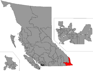
Kootenay East is a provincial electoral district for the Legislative Assembly of British Columbia, Canada. It was created before the 1966 election by the merger of Cranbrook and Fernie ridings, and despite its long period under the "Kootenay" moniker, never extended to cover more than a fraction of the whole "Kootenay" region.

The Columbia Mountains are a group of mountain ranges along the Upper Columbia River in British Columbia, Montana, Idaho and Washington. The mountain range covers 135,952 km². The range is bounded by the Rocky Mountain Trench on the east, and the Kootenai River on the south; their western boundary is the edge of the Interior Plateau. Seventy-five percent of the range is located in Canada and the remaining twenty-five percent in the United States; American geographic classifications place the Columbia Mountains as part of the Rocky Mountains complex, but this designation does not apply in Canada. Mount Sir Sandford is the highest mountain in the range, reaching 3,519 metres (11,545 ft).
Height of the Rockies Provincial Park is a provincial park in the Canadian Rockies of south eastern British Columbia, Canada. It is located west of the Continental Divide, adjacent to Elk Lakes Provincial Park.

The Purcell Wilderness Conservancy is a provincial park in British Columbia, Canada. It was established in 1974, and encompasses six large drainages in the Purcell Mountains in the southeast of the province. It contains high peaks, alpine meadows and ridges, deep creek and river valleys, and hot springs at Dewar Creek.

The British Columbia Interior, popularly referred to as the BC Interior or simply the Interior, is a geographic region of the Canadian province of British Columbia. While the exact boundaries are variously defined, the British Columbia Interior is generally defined to include the 14 regional districts that do not have coastline along the Pacific Ocean or Salish Sea, and are not part of the Lower Mainland. Other boundaries may exclude parts of or even entire regional districts, or expand the definition to include the regional districts of Fraser Valley, Squamish–Lillooet, and Kitimat–Stikine.
The Roman Catholic Diocese of Nelson is a suffragan of the Archdiocese of Vancouver.

Marion was a small sternwheel steamboat that operated in several waterways in inland British Columbia from 1888 to 1901.

Francis Patrick Armstrong was a steamboat captain in the East Kootenay region of British Columbia. He also operated steamboats on the Kootenay River in Montana and on the Stikine River in western British Columbia. Steam navigation in the Rocky Mountain Trench which runs through the East Kootenay region was closely linked to Armstrong's personality and career. In addition to being a steamboat captain, Armstrong was also a prospector, white-water boat pilot and guide in the Big Bend country of the Columbia River.

From 1886 to 1920, steamboats ran on the upper reaches of the Columbia and Kootenay in the Rocky Mountain Trench, in western North America. The circumstances of the rivers in the area, and the construction of transcontinental railways across the trench from east to west made steamboat navigation possible.
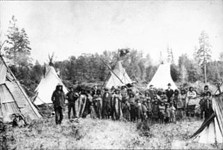
ʔaq̓am, also called St. Mary's Indian Band, are a First Nation based in the East Kootenay region of British Columbia. In the British Columbia Treaty Process They are part of the Ktunaxa Kinbasket Tribal Council.

Pierre-Jean De Smet, SJ, also known as Pieter-Jan De Smet, was a Flemish Catholic priest and member of the Society of Jesus (Jesuits). He is known primarily for his widespread missionary work in the mid-19th century among the Native American peoples, in the midwestern and northwestern United States and western Canada.