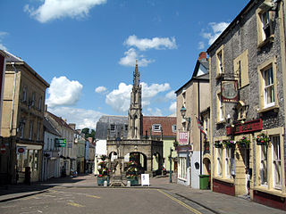
Shepton Mallet is a market town and civil parish in the Mendip District of Somerset, England, some 16 miles (26 km) south-west of Bath, 18 miles (29 km) south of Bristol and 5 miles (8.0 km) east of Wells. It had an estimated population of 10,810 in 2019. Mendip District Council is based there. The Mendip Hills lie to the north and the River Sheppey runs through the town, as does the route of the Fosse Way, the main Roman road between north-east and south-west England. There is evidence of Roman settlement. Its listed buildings include a medieval parish church. Shepton Mallet Prison was England's oldest, but closed in March 2013. The medieval wool trade gave way to trades such as brewing in the 18th century. It remains noted for cider production. It is the closest town to the Glastonbury Festival and nearby the Royal Bath and West of England Society showground.

Mendip is a local government district of Somerset in England. The district covers a largely rural area of 285 square miles (738 km2) with a population of approximately 112,500, ranging from the Wiltshire border in the east to part of the Somerset Levels in the west. The district takes its name from the Mendip Hills which lie in its northwest. The administrative centre of the district is Shepton Mallet but the largest town is Frome.

Pilton is a village and civil parish in Somerset, England, situated on the A361 road in the Mendip district, 3 miles (5 km) south-west of Shepton Mallet and 6 miles (10 km) east of Glastonbury. The village has a population of 998. The parish includes the hamlets of West Compton, East Compton, Westholme, Beardly Batch and Cannards Grave.

The East Somerset Railway is a 2+1⁄2-mile (4 km) heritage railway in Somerset, running between Cranmore and Mendip Vale. Prior to the Beeching Axe, the railway was once part of the former Cheddar Valley line that ran from Witham to Yatton, meeting the Somerset and Dorset Joint Railway at Wells.

Ashwick is a village in the Mendip district of Somerset, England, about three miles north of Shepton Mallet and seven miles east from Wells. It has also been a civil parish since 1826. The parish had a population of 1,352 according to the 2011 census, and apart from Ashwick village also includes Gurney Slade and Oakhill.

Cranmore is a village and civil parish east of Shepton Mallet, in the Mendip district of Somerset, England. The parish includes the hamlets of Waterlip, East Cranmore and Dean.

Ditcheat is a village and civil parish 4.5 miles (7 km) south of Shepton Mallet, and 2.5 miles (4 km) north-west of Castle Cary, in the Mendip district of Somerset, England. Besides the village, the parish has four hamlets: Wraxall, Lower Wraxall, Alhampton and Sutton.

Doulting is a village and civil parish 1.5 miles (2 km) east of Shepton Mallet, on the A361, in the Mendip district of Somerset, England.
Pylle is a village and civil parish 4 miles (6.4 km) south west of Shepton Mallet, and 7 miles (11.3 km) from Wells, in the Mendip district of Somerset, England. It has a population of 160. The parish includes the hamlet of Street on the Fosse.

Stoke St Michael is a village and civil parish on the Mendip Hills 4 miles (6.4 km) north east of Shepton Mallet, and 8 miles (12.9 km) west of Frome, in the Mendip district of Somerset, England.

The Church of St Aldhelm in Doulting, Somerset, England, dates from the 12th century. It is a Grade I listed building.

The Church of All Saints in East Pennard, Somerset, England, dates from the 14th century. It is a grade I listed building.

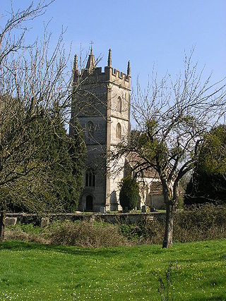
The Church of St Peter and St Paul in Shepton Mallet, Somerset, England, dates from the 12th century and has been designated as a Grade I listed building.

The Church of St Matthew in Wookey, Somerset, England, dates from the twelfth century and is a Grade I listed building.

Southill House in Cranmore, Somerset, England, is an early 18th-century manor house. It was given a new facade by John Wood, the Younger, of Bath, in the late 18th century. It has been designated as a Grade I listed building.

The Church of St James is a Church of England parish church in Curry Mallet, Somerset. It has 13th-century origins and has been designated as a Grade I listed building.

The Church of St Michael in Shepton Beauchamp, Somerset, England is built of local hamstone, and has 13th-century origins, although it has been extensively changed since then, with major renovation in 1865 by George Edmund Street. It has been designated as a Grade I listed building.
Shepton Mallet was a rural district in Somerset, England, from 1894 to 1974.

St James' Church is a former Church of England church in East Cranmore, Somerset, England. Designed by Thomas Henry Wyatt, it was built in 1846 to replace an earlier church on the same site and closed in 1958. The church, now a private residence, is a Grade II listed building.

