The Eastern Cape is one of the nine provinces of South Africa. Its capital is Bhisho, but its two largest cities are East London and Gqeberha. Due to its climate and nineteenth century towns, it is a common location for tourists. It is also known for being home to many anti-apartheid activists, the most famous being Nelson Mandela hailing from the province.

Nelson Mandela University, formerly Nelson Mandela Metropolitan University, is a public university in South Africa. Established in 2005, it comprises the former University of Port Elizabeth, the Port Elizabeth Technikon and Vista University's Port Elizabeth campus. This university has its main administration in the coastal city of Gqeberha.

Uitenhage, officially renamed Kariega, is a South African town in the Eastern Cape Province. It is well known for the Volkswagen factory located there, which is the biggest car factory on the African continent. Along with the city of Port Elizabeth and the small town of Despatch, it forms the Nelson Mandela Bay Metropolitan Municipality.

The Nelson Mandela Bay Municipality is one of eight metropolitan municipalities in South Africa. It is located on the shores of Algoa Bay in the Eastern Cape province and comprises the city of Gqeberha, the nearby towns of Uitenhage and Despatch, and the surrounding rural area.

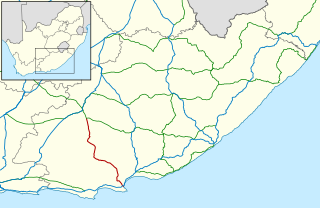
The R75 is a provincial route in Eastern Cape, South Africa that connects Graaff-Reinet with Gqeberha via Despatch, Kariega and Jansenville.

Gqeberha, previously named Port Elizabeth, and colloquially referred to as P.E., is a major seaport and the most populous city in the Eastern Cape province of South Africa. It is the seat of the Nelson Mandela Bay Metropolitan Municipality, South Africa's second-smallest metropolitan municipality by area. It is the sixth-most populous city in South Africa and is the cultural, economic and financial hub of the Eastern Cape.

The N2 is a national route in South Africa that runs from Cape Town through George, Gqeberha, East London, Mthatha, Port Shepstone and Durban to Ermelo. It is the main highway along the Indian Ocean coast of the country. Its current length of 2,255 kilometres (1,401 mi) makes it the longest numbered route in South Africa.

Algoa Bay is a maritime bay in the Eastern Cape, South Africa. It is located on the east coast, 683 kilometres (424 mi) east of the Cape of Good Hope.
New Brighton is a township in the Eastern Cape, South Africa. It forms part of the greater township of Ibhayi and the Nelson Mandela Bay Metropolitan Municipality which governs Port Elizabeth and its surroundings.

The Nelson Mandela Bay Stadium is a soccer and rugby union stadium in Gqeberha in the Eastern Cape province of South Africa. It hosted 2010 FIFA World Cup matches, including the third-place play off. It is the home of Chippa United Football Club and formerly of rugby union team Southern Kings.

St George's Park is a multi-use park in Gqeberha, South Africa. The park is the oldest park in Gqeberha and most commonly associated with the St George's Oval cricket grounds located within the park.
Colchester is a town in the Eastern Cape province of South Africa. It forms part of the Nelson Mandela Bay Metropolitan Municipality which governs Gqeberha and surrounding towns and suburbs.
iBhayi is a large township near Port Elizabeth, South Africa. It is the second largest township in the Eastern Cape province and the ninth largest in South Africa after Mitchells Plain near Cape Town in the Western Cape.
Motherwell is a township in the Eastern Cape province of South Africa. It forms part of the Nelson Mandela Bay Metropolitan Municipality which is the metropolitan area comprising Gqeberha, Despatch, Uitenhage and other surrounding towns.
The Donkin Heritage Trail is a 5 km self-guided walking trail along the old hill of central Port Elizabeth, Eastern Cape, South Africa. The Donkin Heritage Trail is named after the acting Governor of the Cape Colony, Rufane Shaw Donkin.
The following is a timeline of the history of Port Elizabeth in the Nelson Mandela Bay Municipality, Eastern Cape province, South Africa.

Summerstrand is a seaside suburb of Port Elizabeth, South Africa. It is located 6 km (3.7 mi) south-east of the Port Elizabeth city centre. It is primarily a residential suburb along with shopping and business facilities. It is also home to three Nelson Mandela University campuses.
Retief Odendaal is a South African politician who served as the Mayor of Nelson Mandela Bay from 21 September 2022 until his removal in a motion of no confidence on 26 May 2023. Before serving as mayor, he was a Member of the Provincial Legislature in the Eastern Cape for the Democratic Alliance and was the Shadow Member of the Executive Council (MEC) for Finance, Rural Development and Agrarian Reform from May 2019 until August 2022.
Bluewater Bay is a small seaside suburb located along the Algoa Bay between Port Elizabeth and Coega in the Eastern Cape, South Africa.
The 2022 COSAFA Women's Championship is the 10th edition of the COSAFA Women's Championship, a women's international football tournament for national teams organised by COSAFA, teams from Southern Africa. It takes place from 31 August to 11 September 2022 in South Africa.


