
Trinity College is a college federated with the University of Toronto, founded in 1851 by Bishop John Strachan. Strachan originally intended Trinity as a university of strong Anglican alignment, after the University of Toronto severed its ties with the Church of England. After five decades as an independent institution, Trinity joined the university in 1904 as a member of its collegiate federation.
Saint Mary's Academy and College is a religious school of the Society of St. Pius X located in St. Marys, Kansas.

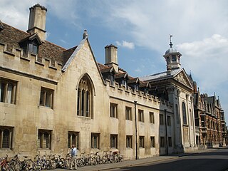
The Sidgwick Site is one of the largest sites within the University of Cambridge, England.

Cottenham is a village in Cambridgeshire, England. Cottenham is one of the larger villages surrounding the city of Cambridge, located around five miles north of the city. The population of the civil parish at the 2011 Census was 6095. Cottenham is one of a number of villages that make up the historical Fen Edge region in between Cambridge and Ely, which were originally settlements on the shore of the marshes close to the city of Cambridge, then an inland port.

King Street is a street in central Cambridge, England. It connects between Sussex Street heading west and Hobson Street heading south at the western end and a large roundabout to the east. It runs parallel to and south of Jesus Lane. The roads link together at a roundabout at the eastern end. To the east is Maid's Causeway and then Newmarket Road leading out of Cambridge. To the north is Victoria Avenue between Jesus Green and Midsummer Common. To the south is Short Street, Cambridge, quickly leading into Emmanuel Road past Christ's Pieces.

Old College is a late 18th-century to early 19th-century building of the University of Edinburgh, Scotland. It is located on South Bridge, and presently houses parts of the University's administration, the University of Edinburgh School of Law, and the Talbot Rice Gallery.

The High Street in Oxford, England, known locally as the High, runs between Carfax, generally seen as the centre of the city, and Magdalen Bridge to the east.

Duroliponte or Durolipons was a small town in the Roman province of Britannia on the site of what is now the city of Cambridge.
St Mary Axe was a mediaeval church in the City of London. Its full name was St Mary, St Ursula and her 11,000 Virgins, and it was also sometimes referred to as St Mary Pellipar. Its common name derives from the sign of an axe over the east end of the church. The church's patrons were the Skinners' Company.

The CambridgeFaculty of Divinity is the divinity school of the University of Cambridge. It houses the Faculty Library.
Trumpington Street is a major historic street in central Cambridge, England. At the north end it continues as King's Parade where King's College is located. To the south it continues as Trumpington Road, an arterial route out of Cambridge, at the junction with Lensfield Road.

Downing Street is a street in central Cambridge, England. It runs between Pembroke Street and Tennis Court Road at the western end and a T-junction with St Andrew's Street at the eastern end. Corn Exchange Street and St Tibbs Row lead off to the north. Downing Place leads off to the south.

Jesus Lane is a street in central Cambridge, England. The street links with the junction of Bridge Street and Sidney Street to the west. To the east is a roundabout. To the south is King Street, running parallel with Jesus Lane and linking at the roundabout. The road continues east as Maid's Causeway and then Newmarket Road east out of Cambridge. To the north is Victoria Avenue between Jesus Green to the west and Midsummer Common to the east. Also to the north near the western end is Park Street, location of the ADC Theatre. To the south is Short Street, quickly leading into Emmanuel Road past Christ's Pieces.

Bene't Street is a short, historic street in central Cambridge, England, the name being derived from St Benedict. There is a junction with King's Parade to the north and Trumpington Street to the south at the western end of the street. Free School Lane leads off to the south. To the east, the street continues as Wheeler Street.

St Andrew's Street is a major street in central Cambridge, England. It runs between Sidney Street, at the junction with Hobson Street, to the northwest and Regent Street to the southeast. Downing Street leads off to the west.
Hills Road is an arterial road in southeast Cambridge, England. It runs between Regent Street at the junction with Lensfield Road and Gonville Place to the northwest and a roundabout by the Cambridge Biomedical Campus, continuing as Babraham Road to the southeast.

The Old Schools are part of the University of Cambridge, in the centre of Cambridge, England. The Old Schools house the Cambridge University Offices, which form the main administration for the University.
Bridge Street is a historic street in the north of central Cambridge, England. It runs between Magdalene Street at the junction with Thompson's Lane to the northwest and Sidney Street at the junction with Jesus Lane to the southeast. Bridge Street used to continue over the Great Bridge on the River Cam, hence the name, but this part is now known as Magdalene Street after Magdalene College, which fronts onto the street.
Lensfield Road is a road in southeast central Cambridge, England. It runs between the junction of Trumpington Street and Trumpington Road to the west and the junction of Regent Street and Hills Road to the west. It continues as Gonville Place to the northeast past Parker's Piece, a large grassed area with footpaths.

All Saints Church is a former church on the north side of the High Street in central Oxford, England, on the corner of Turl Street. It is now the library of Lincoln College. This former church is Grade I listed.


