
Oxfordshire is a landlocked county in the far west of the government statistical region of South East England. The ceremonial county borders Warwickshire to the north-west, Northamptonshire to the north-east, Buckinghamshire to the east, Berkshire to the south, Wiltshire to the south-west and Gloucestershire to the west.

William Butterfield was a Gothic Revival architect and associated with the Oxford Movement. He is noted for his use of polychromy.

Hungerford is a historic market town and civil parish in Berkshire, England, 8 miles (13 km) west of Newbury, 9 miles (14 km) east of Marlborough, 27 miles (43 km) northeast of Salisbury and 60 miles west of London. The Kennet and Avon Canal passes through the town alongside the River Dun, a major tributary of the River Kennet. The confluence with the Kennet is to the north of the centre whence canal and river both continue east. Amenities include schools, shops, cafés, restaurants, and facilities for the main national sports. Hungerford railway station is a minor stop on the Reading to Taunton Line.

St Stephen's House is an Anglican theological college and one of six Permanent Private Halls of the University of Oxford, England.

Bradfield is a village and civil parish in Berkshire, England. Aside from farms and a smaller amount of woodland its main settlements are Bradfield Southend, its medieval-founded nucleus and the hamlet of Tutts Clump. Bradfield village is the home of the public school Bradfield College.

Sir Arthur William Blomfield was an English architect. He became president of the Architectural Association in 1861; a Fellow of the Royal Institute of British Architects in 1867 and vice-president of the RIBA in 1886. He was educated at Trinity College, Cambridge, where he read Architecture.

Cold Ash is a village and civil parish in West Berkshire centred 1 mile (1.6 km) from Thatcham and 2.5 miles (4 km) northeast of Newbury.

The Diocese of Oxford is a Church of England diocese that forms part of the Province of Canterbury. The diocese is led by the Bishop of Oxford, and the bishop's seat is at Christ Church Cathedral, Oxford. It contains more church buildings than any other diocese and has more paid clergy than any other except London.

Leckhampstead is a village and civil parish in West Berkshire, England in the North Wessex Downs. A road and boundary stone in Leckhampstead, the Hangman's Stone and Hangman's Stone Lane, are named after a tale of a man who roped and carried a stolen sheep from a farm in Leckhampstead around his neck, but which strangled him after he stopped and slept. After a long hiatus the area returned to full village status in 1864. Its hamlet of Hill Green has six listed buildings and the amenities of the village include a public house, church and village hall. The associated hamlet of Leckhampstead Thicket has a high proportion of its buildings that are thatched cottages and has a Primitive Methodist chapel, dated 1874.

Brightwalton is a village and civil parish in the Berkshire Downs centred 7 miles (11 km) NNW of Newbury in West Berkshire.

Peasemore is a village and civil parish in the English ceremonial and historic county of Berkshire in the West Berkshire unitary authority area, west of the A34 road and north of the town of Newbury.
St John the Evangelist, Woodley, is a parish church in Woodley, close to Reading in the English county of Berkshire. It is a Church of England church in the Reading Deanery of the Diocese of Oxford.

Steventon is a village and civil parish in Oxfordshire, England, about 4 miles (6.4 km) south of Abingdon and a similar distance west of Didcot. It was part of Berkshire until the 1974 boundary changes transferred it to Oxfordshire. The 2011 Census recorded the parish population as 1,485.
Henry Woodyer (1816–1896) was an English architect, a pupil of William Butterfield and a disciple of A. W. N. Pugin and the Ecclesiologists.
Stephen Ernest Dykes Bower was a British church architect and Gothic Revival designer best known for his work at Westminster Abbey, Bury St Edmunds Cathedral and the Chapel at Lancing College. As an architect he was a devoted and determined champion of the Gothic Revival style through its most unpopular years. He rejected modernism and continued traditions from the late Victorian period, emphasising fine detail, craftsmanship and bright colour.

Fernham is a village and civil parish about 2 miles (3 km) south of Faringdon in the Vale of White Horse, Oxfordshire, England. Fernham was historically part of the parish of Shrivenham. It was within Berkshire until the 1974 local authority boundary changes transferred the Vale of White Horse to Oxfordshire.
The Church of All Saints is a Church of England parish church in Clifton, Bristol. The church is a grade II listed building. It is located in the Parish of All Saints with St. John Clifton in the Diocese of Bristol.

The Church of Saint Michael and All Angels is in the village of Sunninghill, in Berkshire, England. It is an active Anglican parish church in the diocese of Oxford. It is in the parish of Sunninghill and South Ascot with the church of All Souls in South Ascot. It is dedicated to Saint Michael and all angels.

The firm of Goddard & Gibbs were London-based English glassmakers and stained glass window manufacturers. The company was established in 1868, although one firm which it subsequently acquired had been established earlier, in 1855. Goddard & Gibbs itself was formed by a merger in 1938; the company continued to trade until it was acquired by Hardman & Co. in 2006. Hardman itself ceased to trade in 2008.

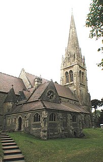
St Joseph's Church is a Roman Catholic parish church in Newbury, Berkshire, England. It was built from 1926 to 1928 in the Italianate style. It is located on the corner of London Road and Western Avenue north of the town centre. According to Historic England, the church is a "major local landmark".

