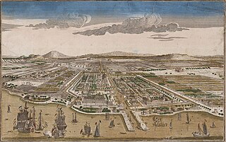
Batavia was the capital of the Dutch East Indies. The area corresponds to present-day Jakarta, Indonesia. Batavia can refer to the city proper or its suburbs and hinterland, the Ommelanden, which included the much larger area of the Residency of Batavia in the present-day Indonesian provinces of Jakarta, Banten and West Java.

Tanjung Priok is a district in the administrative city of North Jakarta, Indonesia. It hosts the western part of the city's main harbor, the Port of Tanjung Priok. The district of Tanjung Priok is bounded by Laksamana Yos Sudarso Tollway and Sunter River canal to the east, by Kali Japat, Kali Ancol, and the former Kemayoran Airport to the southwest, by Sunter Jaya Road and Sunter Kemayoran Road to the south, and by Jakarta Bay to the north.

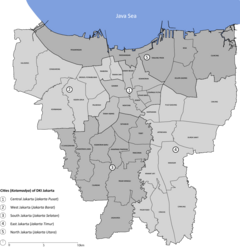
North Jakarta is one of the five administrative cities which form Special Capital Region of Jakarta, Indonesia. North Jakarta is not self-governed and does not have a city council, hence it is not classified as a proper municipality. It contains the entire coastal area within the Jakarta Special District. North Jakarta, along with South Jakarta is the only two cities in Jakarta to border Banten and West Java. It is also the only two cities and regencies of Jakarta with a coastline and not landlocked along with the Thousand Islands Regency. North Jakarta, an area at the estuary of Ciliwung river was the main port for the kingdom of Tarumanegara, which later grew to become Jakarta. Many historic sites and artefacts of Jakarta can be found in North Jakarta. Both ports of Tanjung Priok and historic Sunda Kelapa are located in the city. The city, which covers an area of 139.99 km2, had 1,645,659 inhabitants at the 2010 census and 1,778,981 at the 2020 census; the official estimate as at mid 2022 was 1,793,550 - comprising 905,575 males and 887,975 females. It has its administrative centre in Tanjung Priok.
Gambir is a district in the administrative city of Central Jakarta, Indonesia.. It is characterized by many historic buildings from the colonial era. It hosts some of the foremost political and learning/tourism features of the capital. The Merdeka Palace, the National Museum, the headquarters of the Indonesian Scout Movement and the Merdeka Square are among these.

Sawah Besar is a district (kecamatan) of Central Jakarta, Indonesia. Its neighborhoods are among the most historic, containing the 1820-established Pasar Baru, the new colonial city – Weltevreden – and the old course of the Ciliwung river. Landmarks include the Lapangan Banteng, the government's 19th century-built, low-rise A.A. Maramis Building and its high palmed-lawned vista, and Jakarta Cathedral.

Cilincing is a historic neighborhood of the coast of Jakarta, Indonesia. It is sandwiched between the Port of Tanjung Priok to the west and River Titram to the east. Cilincing has been for some decades one of the districts of North Jakarta which in turn encompasses as far as Marunda and some non-coastal hinterland.

Pademangan is a port-associated subdistrict of North Jakarta, Indonesia. It stretches from the Sunda Kelapa Harbor on the east to the western area of Tanjung Priok Harbor to the east. Geographically, it is a plain with an average height of 75 centimeters above the high tide sea level.

Kota Tua Jakarta, officially known as Kota Tua, is a neighborhood comprising the original downtown area of Jakarta, Indonesia. It is also known as Oud Batavia, Benedenstad, or Kota Lama.
Jakarta is Indonesia's capital and largest city. Located on an estuary of the Ciliwung River, on the northwestern part of Java, the area has long sustained human settlement. Historical evidence from Jakarta dates back to the 4th century CE, when it was a Hindu settlement and port. The city has been sequentially claimed by the Indianized kingdom of Tarumanegara, the Hindu Kingdom of Sunda, the Muslim Sultanate of Banten, and by Dutch, Japanese and Indonesian administrations. The Dutch East Indies built up the area before it was taken during World War II by the Empire of Japan and finally became independent as part of Indonesia.
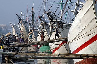
Sunda Kelapa is the old port of Jakarta, located on the estuary of the Ciliwung River. "Sunda Kalapa" is the original name, and it was the main port of the Sunda Kingdom. The port is situated in Penjaringan District, of North Jakarta, Indonesia. Today the old port only accommodates pinisi, a traditional two-masted wooden sailing ship providing inter-island freight service in the archipelago. Although it is now only a minor port, Jakarta has its origins in Sunda Kelapa and it played a significant role in the city's development. The port is currently operated by the state-owned Indonesia Port Corporations.

The Jakarta History Museum, also known as Fatahillah Museum or Batavia Museum, is located in the Old Town of Jakarta, Indonesia. The building was built in 1710 as the Stadhuis of Batavia. Jakarta History Museum opened in 1974 and displays objects from the prehistory period of the city region, the founding of Jayakarta in 1527, and the Dutch colonization period from the 16th century until Indonesia's Independence in 1945.
Port of Tanjung Priok is the busiest and most advanced Indonesian seaport, handling more than 50% of Indonesia's trans-shipment cargo traffic. The port is located at Tanjung Priok, North Jakarta, which is operated by Indonesian state owned PT Pelindo. The port loaded and unloaded 6.2 million, 6.92 million, and 7.8 million TEUs of cargo during 2016, 2017 and 2018 respectively, out of a total capacity of about 8 million TEUs. The container port ranked as 22nd busiest in the world by Lloyd's One Hundred Ports 2019.

The Maritime Museum is located in the old Sunda Kelapa harbor area in Penjaringan Administrative Village, Penjaringan Subdistrict, Jakarta, Indonesia. The museum was inaugurated inside the former Dutch East India Company warehouses. The museum focuses on the maritime history of Indonesia and the importance of the sea to the economy of present-day Indonesia.

Ancol is a coastal lowland area located to the east of Kota Tua Jakarta in northern Jakarta, in Indonesia. The coastal lowland stretched from Kota Tua Jakarta to the west and Tanjung Priok to the east. Today, Ancol contains the main beach resort of Jakarta. Taman Impian Jaya Ancol, the largest integrated tourism area in Southeast Asia, is located in Ancol.
The following is a timeline of the history of the city of Jakarta, Indonesia.
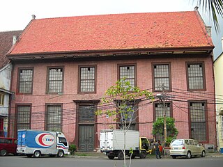
Toko Merah is a Dutch colonial landmark in Jakarta Old Town, Indonesia. Built in 1730, it is one of the oldest buildings in Jakarta. The building is located on the west side of the main canal Kali Besar. The building's red color contributes to its current name.

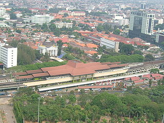
Tanjung Priuk Station (TPK), is a railway station in Tanjung Priok, Tanjung Priok, North Jakarta. It is located across the Tanjung Priok Port, which is the main port of Jakarta. This station is one of the oldest in Jakarta and the biggest station built during the Dutch East Indies era. It is included in the list of heritage buildings by the government of Jakarta.
The Jakarta Kota–Manggarai railway, nicknamed the rainbow line, is an elevated, 15 km long railway line that connects Jakarta Kota with Manggarai. Given its central position in the city, it is one of the most important railways in Jakarta.
The following outline is provided as an overview of and topical guide to Jakarta:
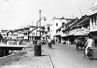
Prinsen Straat, or Prince Street in English, was one of the busiest main streets in Batavia, Dutch East Indies where business and trade took place. It is now called Jalan Cengkeh in Jakarta. Jalan Cengkeh is located in the main area surrounding Kota Tua.