
Middlesbrough is a town in North Yorkshire, England. The town lies near the mouth of the River Tees, forming part of the Teesside built-up area, and is located north of the North York Moors National Park. The wider Borough of Middlesbrough had a population 148,215 at the 2021 UK census. Middlesbrough is the largest town of the wider urban Tees Valley area, which had a population of 678,400 in 2021.

Thornaby-on-Tees, commonly referred to as Thornaby, is a town and civil parish in North Yorkshire, England. Situated on the south bank of the River Tees, approximately 3 miles (4.8 km) west of Middlesbrough and roughly 3 miles (4.8 km) south of Stockton, it forms part of the Teesside built-up area. It had a population of 24,741 at the 2011 census. The town is home to Queen's Campus, Durham University.

The Borough of Stockton-on-Tees is a local government district with borough status which straddles the ceremonial counties of County Durham and North Yorkshire, England. Since 1996 its council has been a unitary authority, being a district council which also performs the functions of a county council. The borough had a population of 196,600 in 2021.

Ingleby Barwick is a town and civil parish in the Borough of Stockton-on-Tees, North Yorkshire, England. It is south of the River Tees and north-east of the River Leven.
Archdeacon Newton is a hamlet and rural parish of several farms in the borough of Darlington and the ceremonial county of County Durham, in England. The population taken at the 2011 Census was less than 100. Details are maintained in the parish of Walworth. It is associated with an abandoned village site under pasture and farm buildings, and situated a short distance to the north-west of Darlington. The lost settlement was in existence by the early 15th century, and remained inhabited at least until the 1890s. There was a moated manor house at the southern end, part of which remains as the Old Hall, now a barn. At the north end of the site was the chapel, and in the middle were tofts and enclosures, with a ridge and furrow field and a trackway leading to the south-east. The site of the abandoned village is now a scheduled monument and the Old Hall is a listed building.

Piercebridge is a village and civil parish in the borough of Darlington and the ceremonial county of Durham, England. The population of the civil parish as of the 2011 census was 113. It is situated a few miles west of the town of Darlington. It is on the site of a Roman fort of AD 260–270, which was built at the point where Dere Street crossed the River Tees. Part of the fort is under the village green. The village is sited where the York-Newstead Roman road known as Dere Street crosses the River Tees.

Egglescliffe is a village and civil parish in County Durham, England. Administratively it is located in the borough of Stockton-on-Tees.

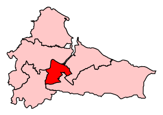
Stockton South was a constituency represented in the House of Commons of the UK Parliament from 2019 until its abolition for the 2024 general election by Matt Vickers of the Conservative Party.
Middlesbrough was a parliamentary constituency in the United Kingdom, recreated in 1974, and represented in the House of Commons of the UK Parliament from 2012 until its abolition for the 2024 general election by Andy McDonald of the Labour Party. An earlier version of the seat existed between 1868 and 1918.

Acklam is an area in the Borough of Middlesbrough, North Yorkshire, England. It is believed that the settlement is Anglo-Saxon in origin, the name is Old English for "place at the oak clearings" or "place of oaks". Acklam was an ancient parish, being known as West Acklam to distinguish it from Acklam in Ryedale.

Ormesby a village in North Yorkshire, England. Its governance is split between two unitary authorities, to the north Middlesbrough and to the south Redcar and Cleveland, both are part of the devolved Tees Valley area. It is in the Middlesbrough part of the Teesside built up area.
Acklam Grange School is a co-educational secondary school located at Lodore Grove, Acklam, Middlesbrough, England.
Middlesbrough West was a parliamentary constituency in the town of Middlesbrough in North East England. It returned one Member of Parliament (MP) to the House of Commons of the Parliament of the United Kingdom, elected by the first-past-the-post voting system.
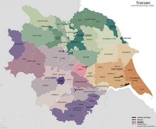
Langbaurgh West was a division of the wapentake of Langbaurgh in the North Riding of the ancient county of Yorkshire. The area along with Langbaurgh East forms the Anglo-Saxon baronial Liberty of Cleveland and roughly covers the modern districts of Middlesbrough, the western, urbanised portion of Redcar & Cleveland, the southern portion of Stockton-on-Tees, the northern parts of Hambleton and the northern parts of the Borough of Scarborough.

Stainton and Thornton is a civil parish in Middlesbrough, North Yorkshire, England. It consists of the two villages Stainton and Thornton. The population of the civil parish at the 2011 census was 1,243.

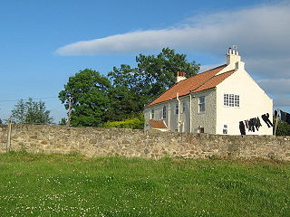
Ulnaby is an abandoned village and scheduled ancient monument in the grounds of Ulnaby Hall Farm, near High Coniscliffe, County Durham, England. The toft village was occupied from the late-13th to the 16th century and temporary buildings were erected in the 19th century. Ulnaby Hall farm appears to have been built in the late-16th century, supplanting a high status medieval manorial enclosure associated with the original village. It is thought that the village shrank because of the change from labour-intensive arable farming to pasture, before being abandoned and the site was subsumed into the farm as pasture.

Middlesbrough started as a Benedictine priory on the south bank of the River Tees, its name possibly derived from it being midway between the holy sites of Durham and Whitby. The earliest recorded form of Middlesbrough's name is "Mydilsburgh", containing the term burgh.
The non-metropolitan county of Cleveland was created under the Local Government Act 1972, which came into effect on 1 April 1974, comprising the urban areas around the mouth of the River Tees, previously parts of the administrative counties of Durham and North Riding of Yorkshire. Although it was abolished in 1996, the four unitary authorities which succeeded it have been considered together for the purposes of reviewing parliamentary boundaries. The area has returned 6 MPs to the UK Parliament since 1983.

Middlesbrough and Thornaby East is a constituency of the House of Commons in the UK Parliament. Further to the completion of the 2023 Periodic Review of Westminster constituencies, it will first be contested in the 2024 general election.

