Standseilbahn Linth-Limmern | |
---|---|
Overview | |
Other name(s) |
|
Status | In operation |
Owner | Kraftwerke Linth-Limmern AG (KLL) |
Locale | Linthal, Glarus, Switzerland |
Coordinates | 46°51′59″N8°59′57″E / 46.8665°N 8.9992°E |
Termini |
|
Website | axpo.com |
Service | |
Type | Funicular, underground |
Rolling stock | 2 for 30 passengers or 120t each (also: 1 for 215 t) |
History | |
Opened | September 2013 |
Technical | |
Line length | 3,778 m (12,395 ft) |
Number of tracks | 1 with passing loop |
Track gauge | 1,800 mm (5 ft 10+7⁄8 in) |
Electrification | from opening (2x 870 kW) |
Operating speed | 6 metres per second (20 ft/s) for 40 t; 0.5 metres per second (1.6 ft/s) for 215 t |
Maximum incline | 24% (constant) |
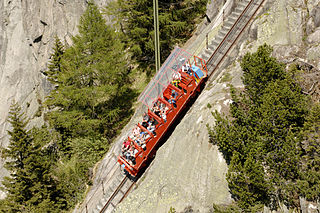
The Standseilbahn Linth-Limmern is a funicular railway at the Linth-Limmern pumped storage plant in the Canton of Glarus in Switzerland. Built in 2013 [1] [2] for a transport capacity of 215 tonnes (237 tons), [3] [4] [5] the funicular moved the four transformers of the hydroelectric plant from Tierfehd at an elevation of 816 m (2,677 ft) to the machinery cavern of the Limmern plant at 1,697 m (5,568 ft). [6] This made it the highest-capacity funicular. [4] The 3,778-metre-long (12,395 ft) line, passing through a tunnel, has an elevation difference of 882 m (2,894 ft) and an incline of 24 per cent. [3] The single track has a passing loop [4] for the descending car.
Since the completion of the plant's expansion, the funicular is used by the staff of and visitors to the hydroelectric plant. It is owned by Kraftwerke Linth-Limmern AG (KLL), a joint venture of Axpo (85%) and the Canton of Glarus (15%). [7]
The lower station is accessed through a short tunnel from Tierfehd, [8] near the aerial cableways to Kalktrittli and Baumgartenalp: 46°52′42″N8°59′14″E / 46.878421°N 8.98714°E . [2]
The upper station is in the machinery cavern near the dam of Limmernsee; 46°50′56″N9°00′39″E / 46.848783°N 9.010871°E . [2] In proximity, another underground funicular leads from Kavernenzentrale Muttsee at 1870 m to Muttenkopf at 2393 m, near Muttsee. [9] [10]
The funicular was built by Garaventa. [1] [11] A tunnel boring machine (TBM) with a diameter of 8 metres (26 ft) was used to excavate the tunnel. [12]
The Glarus Alps are a mountain range in central Switzerland. They are bordered by the Uri Alps and the Schwyz Alps to the west, the Lepontine Alps to the south, the Appenzell Alps to the northeast. The eastern part of the Glarus Alps contains a major thrust fault that was declared a geologic UNESCO World Heritage Site.
Linthal is a village and former municipality in the municipality of Glarus Süd and canton of Glarus in Switzerland. The village lies near the head of the valley of the Linth river, and at the foot of the Klausen Pass into the canton of Uri. It is the terminus of the railway line that traverses the length of Glarus.
Betschwanden is a village and former municipality in the municipality of Glarus Süd and canton of Glarus in Switzerland.
Haslen is a village, and former municipality, in the municipality of Glarus Süd and canton of Glarus in Switzerland.
Luchsingen is a village and former municipality in the municipality of Glarus Süd and canton of Glarus in Switzerland.
Mitlödi is a village and former municipality, in the municipality of Glarus Süd and canton of Glarus in Switzerland.
Schwanden is a village, and former municipality, in the municipality of Glarus Süd and canton of Glarus in Switzerland.
Rüti is a village, and former municipality, in the municipality of Glarus Süd and canton of Glarus in Switzerland.
Leuggelbach is a village, and former municipality, in the municipality of Glarus Süd and canton of Glarus in Switzerland.
Nidfurn is a village, and former municipality, in the municipality of Glarus Süd and canton of Glarus in Switzerland.
Diesbach is a village, and former municipality, in the municipality of Glarus Süd and canton of Glarus in Switzerland.
The Gelmer Funicular is a cable railway in the canton of Bern, Switzerland. It links a lower terminus at Handegg, in the Haslital, with an upper terminus at the Gelmersee lake, 448 m above.
Kraftwerke Oberhasli AG (KWO) is a Swiss energy supply company, based in Innertkirchen (BE) and operating several hydroelectric plants in the Oberhasli area of the Canton of Berne. It also operates a number of tourist attractions in the same area, mostly with some relationship to its energy supply business. It uses the brands Grimselstrom and Grimselwelt, the latter specifically for its tourism ventures. Both brands are named after the Grimsel Pass that forms the upper end of its operating area.
Glarus Süd is a municipality in the Swiss canton of Glarus. It comprises the upper Linth valley, and the entire Sernf valley, and includes the villages of Betschwanden, Braunwald, Diesbach, Elm, Engi, Haslen, Hätzingen, Leuggelbach, Linthal, Luchsingen, Matt, Mitlödi, Nidfurn, Rüti, Schwanden, Schwändi and Sool.
The Linth–Limmern Power Stations are a system of hydroelectric power stations located south of Linthal in the canton of Glarus, Switzerland. The system uses five reservoirs and four power stations at steep variations in altitude.
The Braunwaldbahn, Braunwald-Standseilbahn (BRSB), or Braunwald Funicular, is a funicular railway in the canton of Glarus, Switzerland. The line links Linthal Braunwaldbahn station, on the Swiss Federal Railways' Weesen to Linthal line, with the car-free resort of Braunwald on the mountain 605 m above.
Axpo Holding AG, headquartered in Baden in the canton of Aargau, and its subsidiaries constitute the energy company Axpo. Axpo Holding AG was established in 2001, is 100-percent publicly owned and originates from the former Nordostschweizerischen Kraftwerke AG, NOK.
The S25 is a regional railway line of the S-Bahn Zürich on the Zürcher Verkehrsverbund (ZVV), Zürich transportation network, and is one of the network's lines connecting the cantons of Zürich with Schwyz, Glarus and St. Gallen. The line was introduced in July 2014, and replaces the less frequent Glarner Sprinter train.
{{citation}}
: CS1 maint: location missing publisher (link)